1960s Maps of Danville, Illinois
Explore 4 historic maps of Danville from the 1960s. These maps offer a rare glimpse into what life looked like during the 1960s — showing old roads, neighborhoods, homes, and landmarks that have changed or disappeared over time.
Whether you're researching your family's past, planning a metal detecting trip, or studying how Danville's landscape evolved across the 1960s, these high-resolution maps are a powerful tool for exploring the history of this region.
- Focus on a specific era: All maps on this page are from the 1960s, giving you a focused view of this time period.
- See what’s changed: Compare century-old streets, trails, and buildings to today's modern landscape using overlays and satellite layers.
- Research with precision: Use these maps for genealogy, historical research, land use analysis, or educational projects.
- View, download, or print: Maps are fully viewable online in high resolution, and can be downloaded or printed for your own records.
Start exploring Danville's history through authentic maps from the 1960s. This is your window into the past.
Danville, IL maps
(4)- 1966 Map of Danville SE, 1967 Print
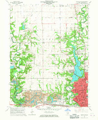
 1966 Danville SE1967 Print · USGSThe bluffs of the Vermilion River and the expanding south side of Danville are captured here in the mid-sixties. Genealogists and historians can trace numerous rural burial sites like Atherton Cem or locate the University of Illinois Radio Telescope.2 unique versions available
 - 1966 Map of Danville SW, 1967 Print
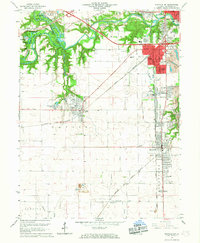 1966 Danville SW1967 Print · USGSVermilion County in the mid-sixties reveals a landscape shaped by coal extraction and heavy rail. Genealogists and historians can trace family plots at Oak Ridge Cemetery or study the industrial layout of the Deep Valley Mine and V-Day Mine.2 unique versions available
 - 1966 Map of Danville NE, 1967 Print
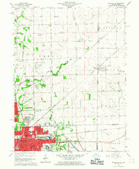 1966 Danville NE1967 Print · USGSThe Illinois-Indiana borderlands come to life in the mid-1960s as Danville expands toward the state line. Genealogists and historians can trace rail-side settlements like Newell and find several family-named landmarks including Leonard Cem and Bryley Cem.2 unique versions available
 - 1966 Map of Danville NW, 1967 Print
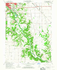
 1966 Danville NW1967 Print · USGSThe northern edge of Danville in the mid-sixties reveals a landscape shaped by coal mining and river-fed recreation. Genealogists and historians can trace family burial sites like Snyder Cem and Thurman Cem or the industrial footprint of the Harmarttan Strip Mine.2 unique versions available
End of results
Showing maps 1-4 of 4
Top cities near Danville
- Georgetown historical maps
- Westville historical maps
- Tilton historical maps
- Covington historical maps
- Catlin historical maps
- Eugene historical maps
See more
Top neighborhoods of Danville
Frequently asked questions
- What are the different types of historical maps available for Danville?
- What is the oldest map of Danville?
- Where can I purchase historical maps of Danville for my home or office?
- Where can I download high-res historical maps of Danville?
- Are there historical topographic maps available for Danville?
- Is there historical aerial imagery available for Danville?
- Where are historical maps of Danville sourced from?