1970s Maps of Indian Prairie Township, Illinois
Explore 3 historic maps of Indian Prairie Township from the 1970s. These maps offer a rare glimpse into what life looked like during the 1970s — showing old roads, neighborhoods, homes, and landmarks that have changed or disappeared over time.
Whether you're researching your family's past, planning a metal detecting trip, or studying how Indian Prairie Township's landscape evolved across the 1970s, these high-resolution maps are a powerful tool for exploring the history of this region.
- Focus on a specific era: All maps on this page are from the 1970s, giving you a focused view of this time period.
- See what’s changed: Compare century-old streets, trails, and buildings to today's modern landscape using overlays and satellite layers.
- Research with precision: Use these maps for genealogy, historical research, land use analysis, or educational projects.
- View, download, or print: Maps are fully viewable online in high resolution, and can be downloaded or printed for your own records.
Start exploring Indian Prairie Township's history through authentic maps from the 1970s. This is your window into the past.
Indian Prairie Township, IL maps
(3)- 1970 Map of Cisne, 1972 Print
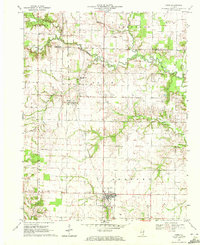 1970 Cisne1972 Print · USGSCisne and the surrounding Wayne County countryside are captured here in the early 1970s, showcasing a landscape where the railroad and oil industry met. Genealogists and local historians can locate several rural burial grounds like Stine Cem and Madden Cem or trace the Baltimore and Ohio rail line past Rinard.
 - 1970 Map of Geff, 1973 Print
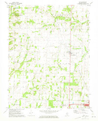 1970 Geff1973 Print · USGSWayne County oil production and rural settlement meet in the early seventies, centered on the community of Geff. Genealogists can locate family landmarks like Young Cem and Oak Valley Ch amidst the active Clay City Oil Field.
 - 1973 Map of Crisp, 1975 Print
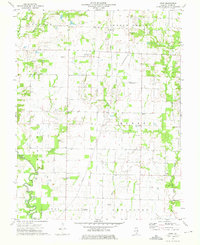 1973 Crisp1975 Print · USGSWayne County farmland and oil fields are captured here in the early seventies, showing a landscape defined by small settlements and family plots. Trace rural roots at Crisp or locate ancestral sites like Anderson Cem and the New Zion Ch.
End of results
Showing maps 1-3 of 3
Top cities near Indian Prairie Township
- Fairfield historical maps
- Flora historical maps
- Wayne City historical maps
- Clay City historical maps
- Bluford historical maps
- Cisne historical maps
See more
Top neighborhoods of Indian Prairie Township
Frequently asked questions
- What are the different types of historical maps available for Indian Prairie Township?
- What is the oldest map of Indian Prairie Township?
- Where can I purchase historical maps of Indian Prairie Township for my home or office?
- Where can I download high-res historical maps of Indian Prairie Township?
- Are there historical topographic maps available for Indian Prairie Township?
- Is there historical aerial imagery available for Indian Prairie Township?
- Where are historical maps of Indian Prairie Township sourced from?