1920s Maps of Will County, Illinois
Explore 9 historic maps of Will County from the 1920s. These maps offer a rare glimpse into what life looked like during the 1920s — showing old roads, neighborhoods, homes, and landmarks that have changed or disappeared over time.
Whether you're researching your family's past, planning a metal detecting trip, or studying how Will County's landscape evolved across the 1920s, these high-resolution maps are a powerful tool for exploring the history of this region.
- Focus on a specific era: All maps on this page are from the 1920s, giving you a focused view of this time period.
- See what’s changed: Compare century-old streets, trails, and buildings to today's modern landscape using overlays and satellite layers.
- Research with precision: Use these maps for genealogy, historical research, land use analysis, or educational projects.
- View, download, or print: Maps are fully viewable online in high resolution, and can be downloaded or printed for your own records.
Start exploring Will County's history through authentic maps from the 1920s. This is your window into the past.
Will County, IL maps
(9)- 1923 Map of Joliet
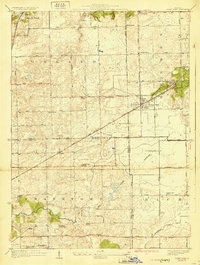
 1923 Joliet1923 Print · USGSJoliet and the Des Plaines River valley are shown here in the 1920s, a hub of heavy industry and vital shipping canals. Genealogists and local historians can trace family roots through numerous country schools like Spaulding School, the Du Page Church, and the expansive State Penitentiary Farm.5 unique versions available
 - 1923 Map of Herscher, 1959 Print
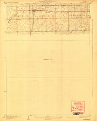
 1923 Herscher1959 Print · USGSKankakee and Will Counties in the early twenties show a landscape defined by busy rail junctions and a dense network of rural school districts. Genealogists and researchers can locate family-named landmarks and infrastructure like the Lehigh Stone Co Quarry, Appel Siding, and Essex Center School.2 unique versions available
 - 1925 Map of Yorkville
 1925 Yorkville1925 Print · USGSKendall County in the mid-twenties shows a landscape of river-valley commerce and a dense network of interurban electric rail lines. Genealogists can locate family-named schoolhouses like Tamarack School and rural hubs such as Platteville and Helmar.2 unique versions available
 - 1925 Map of Herscher
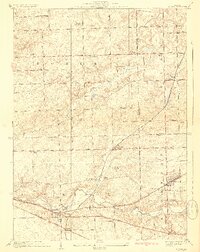
 1925 Herscher1925 Print · USGSKankakee and Grundy counties appear here during the 1920s as a thriving corridor of railroads and rural schools. Genealogists can trace family names through landmarks like Yates School, Clarke City, and the Lehigh Stone Co Quarry.2 unique versions available
 - 1928 Map of Sag Bridge
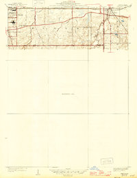
 1928 Sag Bridge1928 Print · USGSThe Des Plaines valley in the late 1920s reveals a complex network of canals and railways connecting Lemont and Willow Springs. Trace early twentieth-century landmarks like Visitation Boys Camp, Fairmont Cemetery, and the Derby School.4 unique versions available
 - 1929 Map of Tinley Park
 1929 Tinley Park1929 Print · USGSThe Cook and Will County borderlands appear here in the late twenties, showing the early suburban footprints of Tinley Park and Orland Park. Researchers can trace rural school locations like Sedan Prairie School or family sites near the Frankfort Cemetery.3 unique versions available
 - 1929 Map of Brisbane
 1929 Brisbane1929 Print · USGSWill County’s rural prairie was a nexus of steam rail traffic in the late twenties, centered on the village of Brisbane. Genealogists and rail historians can trace the paths of the Michigan Central and Wabash lines alongside local landmarks like Murphy Sch.2 unique versions available
 - 1929 Map of Mokena
 1929 Mokena1929 Print · USGSWill County's rural landscape is captured here in the late 1920s, when small schoolhouses and railroads defined the community. Researchers can trace family history at Brooks Cemetery or follow the Wabash tracks through Hadley and Alpine.3 unique versions available
 - 1929 Map of Dyer, 1946 Print
 1929 Dyer1946 Print · USGSThe industrial suburbs and agricultural lands of the Illinois-Indiana border are captured here in the late 1920s. Researchers can trace the path of the Lincoln Highway and locate long-standing landmarks like the Cats Corner School or Strassburg School.
End of results
Showing maps 1-9 of 9
Top cities of Will County
- Joliet historical maps
- Bolingbrook historical maps
- Romeoville historical maps
- New Lenox historical maps
- Homer Glen historical maps
- Lockport historical maps
See more
Frequently asked questions
- What are the different types of historical maps available for Will County?
- What is the oldest map of Will County?
- Where can I purchase historical maps of Will County for my home or office?
- Where can I download high-res historical maps of Will County?
- Are there historical topographic maps available for Will County?
- Is there historical aerial imagery available for Will County?
- Where are historical maps of Will County sourced from?