1940s Maps of Gibson County, Indiana
Explore 2 historic maps of Gibson County from the 1940s. These maps offer a rare glimpse into what life looked like during the 1940s — showing old roads, neighborhoods, homes, and landmarks that have changed or disappeared over time.
Whether you're researching your family's past, planning a metal detecting trip, or studying how Gibson County's landscape evolved across the 1940s, these high-resolution maps are a powerful tool for exploring the history of this region.
- Focus on a specific era: All maps on this page are from the 1940s, giving you a focused view of this time period.
- See what’s changed: Compare century-old streets, trails, and buildings to today's modern landscape using overlays and satellite layers.
- Research with precision: Use these maps for genealogy, historical research, land use analysis, or educational projects.
- View, download, or print: Maps are fully viewable online in high resolution, and can be downloaded or printed for your own records.
Start exploring Gibson County's history through authentic maps from the 1940s. This is your window into the past.
Gibson County, IN maps
(2)- 1944 Map of Iona
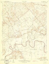 1944 Iona1944 Print · USGSKnox and Gibson counties meet along the high-banked curves of the White River in the early 1940s. Researchers can trace rural lineages through numerous local sites including Slow Cem, West Salem Cem, and the settlement at Iona.2 unique versions available
 - 1944 Map of Vincennes, 1958 Print
 1944 Vincennes1958 Print · USGSThe Wabash River valley during the mid-1940s reveals a landscape of river-town commerce and rural school districts. Genealogists can trace family roots through numerous sites like St Thomas church, the Bunker Hill School, and the small settlement at Billett.
End of results
Showing maps 1-2 of 2
Top cities of Gibson County
- Princeton historical maps
- Johnson historical maps
- Oakland City historical maps
- Fort Branch historical maps
- White River historical maps
- Haubstadt historical maps
See more
Frequently asked questions
- What are the different types of historical maps available for Gibson County?
- What is the oldest map of Gibson County?
- Where can I purchase historical maps of Gibson County for my home or office?
- Where can I download high-res historical maps of Gibson County?
- Are there historical topographic maps available for Gibson County?
- Is there historical aerial imagery available for Gibson County?
- Where are historical maps of Gibson County sourced from?