1900-1909 Maps of Gibson County, Indiana
Explore 10 historic maps of Gibson County from 1900-1909. These maps offer a rare glimpse into what life looked like during the 1900s — showing old roads, neighborhoods, homes, and landmarks that have changed or disappeared over time.
Whether you're researching your family's past, planning a metal detecting trip, or studying how Gibson County's landscape evolved across the 1900s, these high-resolution maps are a powerful tool for exploring the history of this region.
- Focus on a specific era: All maps on this page are from the 1900s, giving you a focused view of this time period.
- See what’s changed: Compare century-old streets, trails, and buildings to today's modern landscape using overlays and satellite layers.
- Research with precision: Use these maps for genealogy, historical research, land use analysis, or educational projects.
- View, download, or print: Maps are fully viewable online in high resolution, and can be downloaded or printed for your own records.
Start exploring Gibson County's history through authentic maps from the 1900s. This is your window into the past.
Gibson County, IN maps
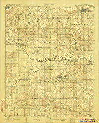
(10)- 1901 Map of Princeton, 1954 Print
 1901 Princeton1954 Print · USGSGIBSON COUNTY at the turn of the century shows a landscape transitioning from river-and-canal transit to a bustling railroad hub. Trace early settlements and infrastructure like the Mt Carmel Ferry, the Wabash and Erie Canal (Abandoned), and the historic community of Lyles.
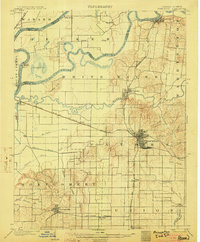
 - 1901 Map of Haubstadt, 1955 Print
 1901 Haubstadt1955 Print · USGSSouthwestern Indiana thrived as a rail-centric farming region at the turn of the century. Genealogists and historians can trace old property lines and rural crossroads like Parker's Settlement, St. Wendells, and the thriving rail hub at Haubstadt.
 - 1902 Map of Ditney
 1902 Ditney1902 Print · USGSSouthern Indiana at the start of the century was a landscape of expanding railroads and rural hamlets. Family historians can trace ancestral roots through dozens of small settlements like Coats Springs, Dongola, and Boonville along the Southern RR.3 unique versions available
 - 1902 Map of Boonville
 1902 Boonville1902 Print · USGSWarrick and Gibson Counties at the opening of the twentieth century reveal a landscape of evolving transport and established rural life. Trace the path of the Wabash and Erie Canal or locate family roots in Boonville, Millersburg, and Lynnville.4 unique versions available
 - 1903 Map of Haubstadt
 1903 Haubstadt1903 Print · USGSSouthern Indiana at the start of the century shows a landscape of busy rail junctions and tight-knit crossroads. Genealogists can trace family footprints across Parker's Settlement, St. Wendells, and McCutchanville as they appeared before modern road expansion.2 unique versions available
 - 1903 Map of New Harmony
 1903 New Harmony1903 Print · USGSPosey County at the opening of the twentieth century was a landscape of thriving river towns and bustling rail junctions. Genealogists and historians can trace the early footprints of New Harmony and Poseyville, or locate vanished locales like Rapture and Solitude.3 unique versions available
 - 1903 Map of Petersburg
 1903 Petersburg1903 Print · USGSSouthwestern Indiana at the turn of the century reveals a landscape shaped by river commerce and the early coal industry. Genealogists can trace family roots in Petersburg or Oakland City, and locate the Erie Canal and Massey Mine.2 unique versions available
 - 1903 Map of Princeton
 1903 Princeton1903 Print · USGSIndiana's southwestern river country is shown at the height of its railroad era, centered on the junction at Princeton. Genealogists and historians can trace old property lines near the County Farm or locate vanished sites along the Wabash and Erie Canal and the settlement of Lyles.6 unique versions available
 - 1903 Map of Patoka
 1903 Patoka1903 Print · USGSThe lower Wabash Valley at the start of the twentieth century was a vital crossroads of river trade and rail expansion. Genealogists can trace family roots through settlements like New Harmony and Parker's Settlement or locate the County Farm and Grand Rapids.2 unique versions available
 - 1904 Map of Mount Carmel
 1904 Mount Carmel1904 Print · USGSMount Carmel and the Wabash River valley are captured here at the height of the steam era. Genealogists and historians can trace defunct rail stops and riverside settlements like Schrodts Sta., Jimtown, and Rochester.3 unique versions available
End of results
Showing maps 1-10 of 10
Top cities of Gibson County
- Princeton historical maps
- Johnson historical maps
- Oakland City historical maps
- Fort Branch historical maps
- White River historical maps
- Haubstadt historical maps
See more
Frequently asked questions
- What are the different types of historical maps available for Gibson County?
- What is the oldest map of Gibson County?
- Where can I purchase historical maps of Gibson County for my home or office?
- Where can I download high-res historical maps of Gibson County?
- Are there historical topographic maps available for Gibson County?
- Is there historical aerial imagery available for Gibson County?
- Where are historical maps of Gibson County sourced from?