1950s Maps of Lake County, Indiana
Explore 24 historic maps of Lake County from the 1950s. These maps offer a rare glimpse into what life looked like during the 1950s — showing old roads, neighborhoods, homes, and landmarks that have changed or disappeared over time.
Whether you're researching your family's past, planning a metal detecting trip, or studying how Lake County's landscape evolved across the 1950s, these high-resolution maps are a powerful tool for exploring the history of this region.
- Focus on a specific era: All maps on this page are from the 1950s, giving you a focused view of this time period.
- See what’s changed: Compare century-old streets, trails, and buildings to today's modern landscape using overlays and satellite layers.
- Research with precision: Use these maps for genealogy, historical research, land use analysis, or educational projects.
- View, download, or print: Maps are fully viewable online in high resolution, and can be downloaded or printed for your own records.
Start exploring Lake County's history through authentic maps from the 1950s. This is your window into the past.
Lake County, IN maps
(24)- 1953 Map of Leroy, 1955 Print
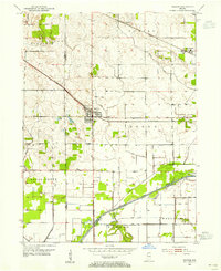
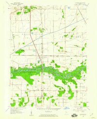
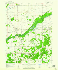
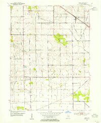 1953 Leroy1955 Print · USGSSouthern Lake County's agricultural heartland is captured here in the early 1950s as a complex system of drainage ditches reclaimed the prairie. Researchers can pinpoint long-standing landmarks including Leroy, the Riley Sch, and Plum Grove Cem.
 - 1953 Map of St. John, 1955 Print
 1953 St. John1955 Print · USGSNorthwest Indiana during the early fifties reveals a landscape where historic rail lines and the Lincoln Highway meet growing lakeside communities. Genealogists and local historians can trace family-named sites like Dutton Cem and Hack Cem, or locate mid-century landmarks such as the Illiana Race Track.
 - 1953 Map of Palmer, 1955 Print
 1953 Palmer1955 Print · USGSPorter County's agricultural heartland is captured here in the early fifties, showing a rural landscape dominated by massive rail corridors and the Lincoln Highway. Genealogists can locate family landmarks like Betz Cem and Ludington Cem or trace the early development around Lake Eliza and Palmer.
 - 1953 Map of Gary, 1955 Print
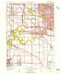
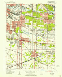
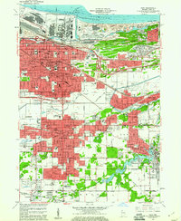
 1953 Gary1955 Print · USGSMid-century Gary and the Calumet region are captured here during a peak era of industrial and suburban growth. Researchers can trace family roots through dozens of local landmarks like Holy Angels Sch, Oak Hill Cemetery, and the Miller neighborhood.
 - 1953 Map of Crown Point, 1955 Print
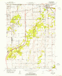
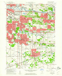
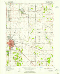 1953 Crown Point1955 Print · USGSLake County is captured in the early fifties as a landscape of established rail hubs and emerging suburbs connected by the historic Lincoln Highway. Researchers can trace local roots at the Bail School, Maplewood Cemetery, and the old County Fairground.
 - 1953 Map of Calumet City, 1955 Print
 1953 Calumet City1955 Print · USGSThe Calumet region during the early fifties shows a burgeoning industrial and suburban landscape spanning the Illinois Indiana state line. Trace the development of local neighborhoods and infrastructure from Chicago Hammond Airport to the Thornton Junction rail hub.
 - 1953 Map of Beecher East, 1955 Print
 1953 Beecher East1955 Print · USGSThe Illinois and Indiana borderlands are captured here in the early fifties, showing a rural landscape defined by rail and farm. Genealogists can locate family landmarks like Deeke Sch, St Johns Ch, and the settlements of Klaasville and Beecher.3 unique versions available
 - 1953 Map of Calumet Lake, 1955 Print
 1953 Calumet Lake1955 Print · USGSThe industrial corridor of the Chicago South Side and Northwest Indiana comes alive in this mid-century survey. Genealogists and historians can trace the footprint of neighborhoods like Pullman, Hegewisch, and Altgeld Gardens alongside the massive rail yards of the Pennsylvania Railroad.
 - 1953 Map of Hebron, 1955 Print
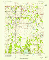
 1953 Hebron1955 Print · USGSPorter County in the early 1950s is defined by its rail-linked small towns and the managed waters of the Kankakee basin. Genealogists and local historians can trace the early layout of Hebron, explore rural Boone Grove, or locate family sites at Hebron Cem.
 - 1953 Map of Dyer, 1955 Print
 1953 Dyer1955 Print · USGSThe Illinois-Indiana border during the early fifties reveals a landscape of growing suburbs and traditional crossroads. Researchers can trace historic family roots at Eagle Lake Cem or locate lost landmarks like Klemme Sch and Lincoln Fields.
 - 1953 Map of Whiting, 1955 Print
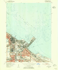 1953 Whiting1955 Print · USGSThe industrial heart of the Calumet Region is captured here in the early fifties during its manufacturing peak. Genealogists and historians can locate neighborhood landmarks like St Joseph College, St Catherine Hospital, and the vast Oil Refinery works.
 - 1953 Map of Garyton, 1955 Print
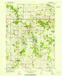
 1953 Garyton1955 Print · USGSNorthwest Indiana's dunes and rail corridors are captured here during the mid-fifties industrial boom. Researchers can trace historic family burial sites at Calvary Cemetery and Jaynes Cem or locate early community hubs like the Seven Dolors Shrine and Portage Central Sch.
 - 1953 Map of Lowell, 1955 Print
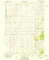
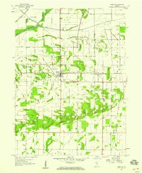
 1953 Lowell1955 Print · USGSSouthern Lake County in the early 1950s is defined by its evolving rail corridors and lakeside settlements. Genealogists can trace rural family life through locations like Sheridan School, St Edwards Cemetery, and the rail stops at North Hayden or Creston.
 - 1953 Map of Ogden Dunes, 1955 Print
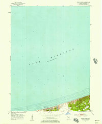 1953 Ogden Dunes1955 Print · USGSThe southern shoreline of Indiana appears in the early fifties as the lakefront community of Ogden Dunes begins to take shape. Researchers can trace the original landscape including the Flowing Well, early residential streets, and the nearby Burns Ditch.2 unique versions available
 - 1953 Map of Highland, 1955 Print
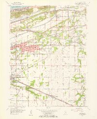
 1953 Highland1955 Print · USGSNorthwest Indiana during the industrial expansion of the 1950s shows a landscape of growing suburbs and massive rail infrastructure. Genealogists and historians can trace neighborhood development near Purdue University, Ridgelawn Cemetery, and the Holy Rosary Ch.
 - 1953 Map of Jackson Park, 1956 Print
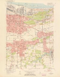
 1953 Jackson Park1956 Print · USGSThe South Side of Chicago and its lakefront are captured here in the early 1950s, showing a period of significant urban growth and shoreline development. Genealogists and historians can trace neighborhood landmarks from Oakwoods Cemetery to the University of Chicago and the aviation grounds of Meigs Field.
 - 1953 Map of Chicago, 1964 Print
 1953 Chicago1964 Print · USGSThe southern Lake Michigan shoreline was rapidly modernizing in the mid-fifties, balancing heavy industry with its famous academic centers. Researchers can trace the footprints of Notre Dame University or locate vanished sites like the Kingsbury Ordnance Plant and Meigs Field.5 unique versions available
 - 1957 Map of Chicago
 1957 Chicago1957 Print · USGSThe industrial heartland and southern Great Lakes shoreline are captured here during the peak of mid-century growth. Researchers can trace the massive Gary Steel Works, the grounds of the University of Notre Dame, and the early paths of the Tri-State Tollway.
 - 1957 Map of DeMotte, 1959 Print
 1957 DeMotte1959 Print · USGSJasper County agricultural life in the late fifties is centered around the New York Central rail line. Researchers can trace family-named roads like Bosma and Schatzley or locate early rural hubs such as Demotte, Kniman, and Kersey.3 unique versions available
 - 1959 Map of Schneider, 1960 Print
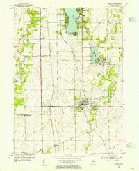
 1959 Schneider1960 Print · USGSThe Lake and Newton county line comes alive in the late fifties, showing a landscape defined by the drainage of the Kankakee marsh. Trace family roots and local industry at Sanders Cem, the New York Central rail lines, and the Sumava Resorts riverfront.4 unique versions available
 - 1959 Map of Shelby, 1960 Print
 1959 Shelby1960 Print · USGSThe Kankakee River valley at the turn of the 1960s was a landscape defined by rail and reclamation. Researchers can trace the Monon line through Shelby and Thayer or locate local landmarks like the Landing Strip and the Singleton Ditch.2 unique versions available
 - 1959 Map of Momence NE, 1960 Print
 1959 Momence NE1960 Print · USGSThe Illinois-Indiana borderlands appear in the late fifties as a landscape defined by industrial rail and massive drainage projects. Genealogists and historians can trace the New York Central line and search for family roots at West Creek Cem near the banks of West Creek.
 - 1959 Map of Gary, 1961 Print
 1959 Gary1961 Print · USGSSteel industry and heavy rail dominated this Lake Michigan shoreline in the late fifties as neighborhoods grew around the factories. Genealogists and researchers can trace the development of early Gary and Hobart through local landmarks like Oak Hill Cemetery, Andrean High Sch, and Liverpool.
 - 1959 Map of Highland, 1961 Print
 1959 Highland1961 Print · USGSNorthwest Indiana's industrial and residential expansion is on full display in this mid-century survey of the Calumet region. Researchers can trace the development of suburban blocks near Highland and Griffith alongside landmarks like Gary Municipal Airport and Wicker Park.
End of results
Showing maps 1-24 of 24
Top cities of Lake County
Frequently asked questions
- What are the different types of historical maps available for Lake County?
- What is the oldest map of Lake County?
- Where can I purchase historical maps of Lake County for my home or office?
- Where can I download high-res historical maps of Lake County?
- Are there historical topographic maps available for Lake County?
- Is there historical aerial imagery available for Lake County?
- Where are historical maps of Lake County sourced from?