1960s Maps of Lake County, Indiana
Explore 20 historic maps of Lake County from the 1960s. These maps offer a rare glimpse into what life looked like during the 1960s — showing old roads, neighborhoods, homes, and landmarks that have changed or disappeared over time.
Whether you're researching your family's past, planning a metal detecting trip, or studying how Lake County's landscape evolved across the 1960s, these high-resolution maps are a powerful tool for exploring the history of this region.
- Focus on a specific era: All maps on this page are from the 1960s, giving you a focused view of this time period.
- See what’s changed: Compare century-old streets, trails, and buildings to today's modern landscape using overlays and satellite layers.
- Research with precision: Use these maps for genealogy, historical research, land use analysis, or educational projects.
- View, download, or print: Maps are fully viewable online in high resolution, and can be downloaded or printed for your own records.
Start exploring Lake County's history through authentic maps from the 1960s. This is your window into the past.
Lake County, IN maps
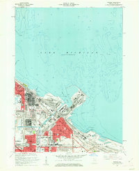
(20)- 1960 Map of Portage, 1961 Print
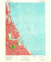
 1960 Portage1961 Print · USGSPorter County's lakefront and industrial heartland are captured here during the post-war boom. Genealogists and historians can trace family-named sites like Robbins Cem and Blake Cem or the development of Garyton and Ogden Dunes along the rails.2 unique versions available
 - 1960 Map of Lake Calumet, 1962 Print
 1960 Lake Calumet1962 Print · USGSThe industrial south side of Chicago and the Indiana borderlands meet in this early 1960s survey. Genealogists and historians can trace neighborhood evolution through parish schools like Our Lady of Hungary Sch, early housing at Altgeld Gardens, and the heavy rail lines of the Pennsylvania RR.
 - 1960 Map of Calumet City, 1962 Print
 1960 Calumet City1962 Print · USGSGreater Chicago's southeastern industrial corridor meets the Indiana state line in this early 1960s survey of burgeoning suburbs and rail hubs. Researchers can trace family roots at Holy Cross Cemetery, locate the old Chicago Hammond Airport, or study the rail network of the Grand Trunk and Monon lines.
 - 1960 Map of Whiting, 1962 Print
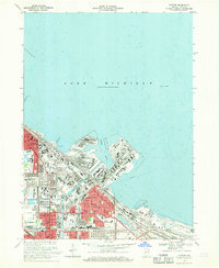
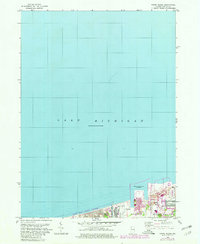
 1960 Whiting1962 Print · USGSThe industrial shoreline of Lake Michigan comes alive in the early sixties, showing the heavy infrastructure of the Indiana steel and oil corridor. Genealogists and local historians can trace neighborhood developments near Mark Town, St Marys Sch, and the extensive Oil Reservoirs of the era.
 - 1962 Map of Palmer, 1964 Print
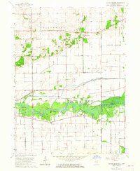
 1962 Palmer1964 Print · USGSPorter and Lake Counties are captured here in the early 1960s, showing a landscape of rural crossroads and dense rail networks. Researchers can trace family history through numerous landmarks like Blachly Cem, Salem Ch, and the community at Lake Eliza.3 unique versions available
 - 1962 Map of Dyer, 1964 Print
 1962 Dyer1964 Print · USGSThe Illinois-Indiana borderland comes alive in the early sixties as suburban growth from Sauk Village meets the rural crossroads of Lake County. Local historians can trace the paths of the Sauk Trail and find family-named landmarks like Katz Corner Sch and St Johns Ch.2 unique versions available
 - 1962 Map of Crown Point, 1964 Print
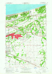
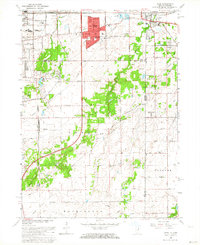
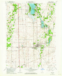
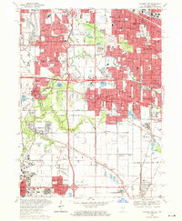
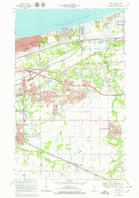
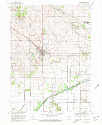
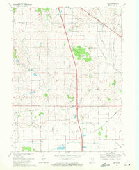
 1962 Crown Point1964 Print · USGSLake County enters a period of post-war growth as suburban subdivisions begin to fill the spaces between established rail lines and historic roads. Genealogists and local historians can trace the foundations of Merrillville, locate the Maplewood Cemetery, and find early landmarks like the Crown Point Airfield.4 unique versions available
 - 1962 Map of Lowell, 1964 Print
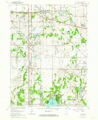
 1962 Lowell1964 Print · USGSLake County at the start of the sixties reveals a landscape shaped by agricultural townships and growing lakeside communities. Genealogists and historians can trace family roots at St Edwards School, German Cemetery, and across the transit corridor of the Monon Railroad.2 unique versions available
 - 1962 Map of St. John, 1964 Print
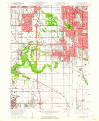
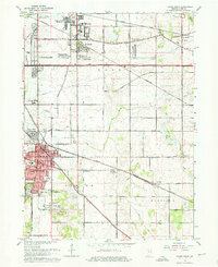
 1962 St. John1964 Print · USGSLake County, Indiana, is captured here in the early 1960s as suburban subdivisions began to fill the spaces between historic rail corridors and township lines. Researchers can trace local landmarks like Hoosier Boys Town, St Johns Seminary, and the Erie Lackawanna railroad.2 unique versions available
 - 1963 Map of Jackson Park, 1964 Print
 1963 Jackson Park1964 Print · USGSThe Chicago lakefront in the early sixties showcases a dense urban landscape defined by major cultural landmarks and rail corridors. Researchers can trace the mid-century South Side grid near the University of Chicago, Oak Woods Cemetery, and the historic Meigs Field.3 unique versions available
 - 1963 Map of Illiana Heights, 1965 Print
 1963 Illiana Heights1965 Print · USGSThe Illinois-Indiana state line comes alive in the early sixties as riverfront life and rail junctions define the Kankakee valley. Genealogists and historians can trace riverside settlements like Garden of Eden, search for family roots at West Creek Cem, or follow the path of the NEW YORK CENTRAL railroad.3 unique versions available
 - 1965 Map of Lake Calumet, 1966 Print
 1965 Lake Calumet1966 Print · USGSSoutheast Chicago and the Indiana borderlands were a powerhouse of rail and industry in the mid-sixties. Researchers can trace historic parish life and neighborhood growth through sites like Altgeld Gardens, Hegewisch, and the Chicago Vocational Sch.4 unique versions available
 - 1968 Map of Calumet City, 1970 Print
 1968 Calumet City1970 Print · USGSThe Illinois-Indiana borderlands reached a peak of industrial and suburban development in the late sixties. Researchers can trace the massive rail networks of the Penn Central and find local landmarks like St Margarets Hospital and the Chicago-Hammond Airport.4 unique versions available
 - 1968 Map of Whiting, 1970 Print
 1968 Whiting1970 Print · USGSIndiana’s industrial lakefront thrives in the late sixties as a powerhouse of rail and maritime commerce. Trace family roots and local landmarks from Whiting to East Chicago, including St Catherines Hospital and the Penn Central rail lines.2 unique versions available
 - 1968 Map of Portage, 1970 Print
 1968 Portage1970 Print · USGSThe Indiana shoreline and its industrial heartland come alive in this late 1960s survey of the dunes and rail corridors. Genealogists and local historians can locate several family landmarks and community anchors like Calvary Cemetery, Seven Dolors Shrine, and Lake Station.4 unique versions available
 - 1968 Map of Gary, 1970 Print
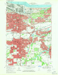 1968 Gary1970 Print · USGSSteel and rail defined the Indiana lakefront in the late sixties as neighborhoods expanded south from Lake Michigan. Genealogists can locate family homes and landmarks like Oak Hill Cemetery, Sacred Heart Sch, and the Indiana Harbor Belt rail lines.3 unique versions available
 - 1968 Map of Highland, 1971 Print
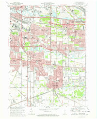 1968 Highland1971 Print · USGSNorthwest Indiana during the late sixties shows a dense network of rail lines and early interstate highways connecting growing industrial suburbs. Genealogists and historians can trace numerous community landmarks from St Marys Cem to the Purdue University (Calumet Center).3 unique versions available
 - 1968 Map of Ogden Dunes, 1980 Print
 1968 Ogden Dunes1980 Print · USGSThe Indiana shoreline was undergoing a dramatic transformation during the late sixties as industry met conservation. Trace the boundaries of the Indiana Dunes National Lakeshore alongside industrial sites like Burns Waterway Harbor and the town of Ogden Dunes.2 unique versions available
 - 1969 Map of Hebron, 1971 Print
 1969 Hebron1971 Print · USGSPorter County is shown during a period of agricultural expansion in the late sixties, as drainage projects reshaped the land. Genealogists can trace family footprints at Hebron Cem or follow the historic rail corridors of the Penn Central and Erie-Lackawanna.2 unique versions available
 - 1969 Map of Leroy, 1971 Print
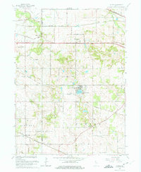
 1969 Leroy1971 Print · USGSSouthern Lake County in the late sixties shows a landscape defined by rail lines and drainage canals. Trace rural ancestry at Plum Grove Cem or locate the old Center Sch and the community of Orchard Grove.2 unique versions available
End of results
Showing maps 1-20 of 20
Top cities of Lake County
Frequently asked questions
- What are the different types of historical maps available for Lake County?
- What is the oldest map of Lake County?
- Where can I purchase historical maps of Lake County for my home or office?
- Where can I download high-res historical maps of Lake County?
- Are there historical topographic maps available for Lake County?
- Is there historical aerial imagery available for Lake County?
- Where are historical maps of Lake County sourced from?