1950s Maps of La Porte, Indiana
Explore 5 historic maps of La Porte from the 1950s. These maps offer a rare glimpse into what life looked like during the 1950s — showing old roads, neighborhoods, homes, and landmarks that have changed or disappeared over time.
Whether you're researching your family's past, planning a metal detecting trip, or studying how La Porte's landscape evolved across the 1950s, these high-resolution maps are a powerful tool for exploring the history of this region.
- Focus on a specific era: All maps on this page are from the 1950s, giving you a focused view of this time period.
- See what’s changed: Compare century-old streets, trails, and buildings to today's modern landscape using overlays and satellite layers.
- Research with precision: Use these maps for genealogy, historical research, land use analysis, or educational projects.
- View, download, or print: Maps are fully viewable online in high resolution, and can be downloaded or printed for your own records.
Start exploring La Porte's history through authentic maps from the 1950s. This is your window into the past.
La Porte, IN maps
(5)- 1953 Map of Chicago, 1964 Print
 1953 Chicago1964 Print · USGSThe southern Lake Michigan shoreline was rapidly modernizing in the mid-fifties, balancing heavy industry with its famous academic centers. Researchers can trace the footprints of Notre Dame University or locate vanished sites like the Kingsbury Ordnance Plant and Meigs Field.5 unique versions available
 - 1957 Map of Chicago
 1957 Chicago1957 Print · USGSThe industrial heartland and southern Great Lakes shoreline are captured here during the peak of mid-century growth. Researchers can trace the massive Gary Steel Works, the grounds of the University of Notre Dame, and the early paths of the Tri-State Tollway.
 - 1958 Map of Michigan City East, 1963 Print
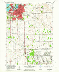
 1958 Michigan City East1963 Print · USGSThe Indiana shoreline and the rail corridors of LaPorte County are captured here at a peak of mid-century industrial and suburban expansion. Researchers can trace historic family locations near Swan Lake Cem or follow the paths of the Monon Railroad and New York Central Railroad.
 - 1958 Map of La Porte East, 1964 Print
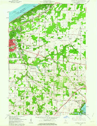
 1958 La Porte East1964 Print · USGSLaPorte County's industrial and residential expansion is evident in the late fifties, featuring the massive Kingsbury Ordnance Plant. Genealogists can trace family sites at Patton Cemetery or locate old schoolhouses like Riley Sch and St Johns Sch.
 - 1958 Map of Springville, 1964 Print
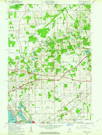 1958 Springville1964 Print · USGSLa Porte County is shown just as modern highways began to reshape the northern Indiana countryside in the late fifties. Researchers can trace historic family landmarks like Potter Chapel and Rossburg Cem alongside early rail routes like the Chicago South Shore and South Bend Railroad.2 unique versions available
End of results
Showing maps 1-5 of 5
Top cities near La Porte
- Michigan City historical maps
- Westville historical maps
- Springfield historical maps
- Kankakee historical maps
- Trail Creek historical maps
- Walkerton historical maps
See more
Top neighborhoods of La Porte
- NewPorte Landing historical maps
- Plaza 618 historical maps
- Monroe Manor historical maps
- Regency Place historical maps
- Whispering Meadows historical maps
Frequently asked questions
- What are the different types of historical maps available for La Porte?
- What is the oldest map of La Porte?
- Where can I purchase historical maps of La Porte for my home or office?
- Where can I download high-res historical maps of La Porte?
- Are there historical topographic maps available for La Porte?
- Is there historical aerial imagery available for La Porte?
- Where are historical maps of La Porte sourced from?