1960s Maps of La Porte, Indiana
Explore 3 historic maps of La Porte from the 1960s. These maps offer a rare glimpse into what life looked like during the 1960s — showing old roads, neighborhoods, homes, and landmarks that have changed or disappeared over time.
Whether you're researching your family's past, planning a metal detecting trip, or studying how La Porte's landscape evolved across the 1960s, these high-resolution maps are a powerful tool for exploring the history of this region.
- Focus on a specific era: All maps on this page are from the 1960s, giving you a focused view of this time period.
- See what’s changed: Compare century-old streets, trails, and buildings to today's modern landscape using overlays and satellite layers.
- Research with precision: Use these maps for genealogy, historical research, land use analysis, or educational projects.
- View, download, or print: Maps are fully viewable online in high resolution, and can be downloaded or printed for your own records.
Start exploring La Porte's history through authentic maps from the 1960s. This is your window into the past.
La Porte, IN maps
(3)- 1961 Map of La Porte West, 1964 Print
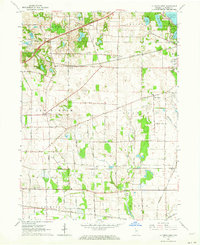 1961 La Porte West1964 Print · USGSLa Porte County at the start of the sixties shows a landscape shaped by early treaty lines and a dense network of major railroads. Genealogists and local historians can trace rural school districts and old settlements such as Door Village, Pinhook, and Pinola.
 - 1969 Map of La Porte West, 1971 Print
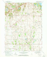 1969 La Porte West1971 Print · USGSThe rural prairie west of La Porte comes alive in the late sixties, showing a landscape defined by glacial lakes and a bustling rail network. Genealogists and historians can locate the Township Sch, Pinhook Cem, and the historic settlement at Door Village.3 unique versions available
 - 1969 Map of Michigan City East, 1971 Print
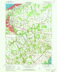 1969 Michigan City East1971 Print · USGSLaPorte County, Indiana, is captured at the end of the sixties as Michigan City expanded into the surrounding townships. Researchers can trace historic rail lines like the Norfolk and Western and locate rural landmarks such as Sharp Cem or the State Prison Farm.2 unique versions available
End of results
Showing maps 1-3 of 3
Top cities near La Porte
- Michigan City historical maps
- Westville historical maps
- Springfield historical maps
- Kankakee historical maps
- Trail Creek historical maps
- Walkerton historical maps
See more
Top neighborhoods of La Porte
- NewPorte Landing historical maps
- Plaza 618 historical maps
- Monroe Manor historical maps
- Regency Place historical maps
- Whispering Meadows historical maps
Frequently asked questions
- What are the different types of historical maps available for La Porte?
- What is the oldest map of La Porte?
- Where can I purchase historical maps of La Porte for my home or office?
- Where can I download high-res historical maps of La Porte?
- Are there historical topographic maps available for La Porte?
- Is there historical aerial imagery available for La Porte?
- Where are historical maps of La Porte sourced from?