1960s Maps of Morgan County, Indiana
Explore 13 historic maps of Morgan County from the 1960s. These maps offer a rare glimpse into what life looked like during the 1960s — showing old roads, neighborhoods, homes, and landmarks that have changed or disappeared over time.
Whether you're researching your family's past, planning a metal detecting trip, or studying how Morgan County's landscape evolved across the 1960s, these high-resolution maps are a powerful tool for exploring the history of this region.
- Focus on a specific era: All maps on this page are from the 1960s, giving you a focused view of this time period.
- See what’s changed: Compare century-old streets, trails, and buildings to today's modern landscape using overlays and satellite layers.
- Research with precision: Use these maps for genealogy, historical research, land use analysis, or educational projects.
- View, download, or print: Maps are fully viewable online in high resolution, and can be downloaded or printed for your own records.
Start exploring Morgan County's history through authentic maps from the 1960s. This is your window into the past.
Morgan County, IN maps
(13)- 1961 Map of Morgantown, 1963 Print
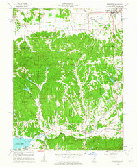 1961 Morgantown1963 Print · USGSThe wooded highlands of Brown and Morgan counties are captured here in the early sixties as rural life centered on the rail corridor. Trace family history through landmarks like Mt Zion Ch, the Williams Cem, and the village of Helmsburg.5 unique versions available
 - 1961 Map of Hindustan, 1963 Print
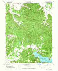 1961 Hindustan1963 Print · USGSIn the early sixties, this area of Monroe County was defined by the expansion of the Morgan-Monroe State Forest and the newly formed Lake Lemon. Researchers can trace the Old Indian Treaty Boundary and locate local landmarks like Hindustan, Stepp Cem, and the Wheeler Mission Campground.5 unique versions available
 - 1962 Map of Indianapolis
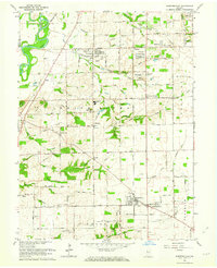
 1962 Indianapolis1962 Print · USGSCentral Indiana and the Illinois borderlands are captured here in the early sixties, showing the region's dense rail networks and growing urban centers. Genealogists and historians can locate family-named landmarks and institutions like Crown Hill Cem, Indiana University, and the Indianapolis Motor Speedway.
 - 1962 Map of Bargersville, 1963 Print
 1962 Bargersville1963 Print · USGSJohnson County is shown here in the early sixties as small crossroads settlements like Kinder and Stones Crossing sat amidst a landscape of family farms. Researchers can locate numerous family burial grounds including Boles Cem and McColgin Cem along the Illinois Central Railroad.4 unique versions available
 - 1962 Map of Bean Blossom, 1964 Print
 1962 Bean Blossom1964 Print · USGSSouthern Indiana ridge country comes alive in the early sixties, showing the transition between JOHNSON CO and BROWN CO. Trace old family roots at Duncan Cem, Mt Carmel Ch, and the crossroads at Spearsville or Gatesville.5 unique versions available
 - 1965 Map of Cope, 1966 Print
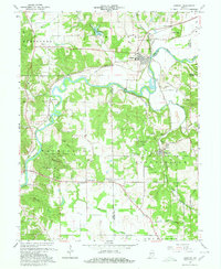
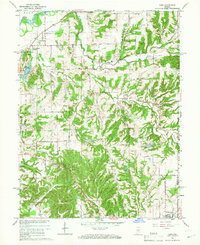 1965 Cope1966 Print · USGSMorgan County in the mid-sixties is a landscape of winding creek valleys and established rural crossroads. Researchers can trace family history through sites like Williams Cem, Nast Chapel, and the small settlement at Cope.3 unique versions available
 - 1965 Map of Mooresville West, 1966 Print
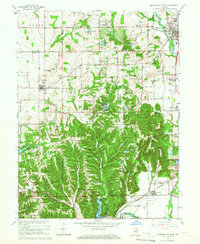 1965 Mooresville West1966 Print · USGSThe White River valley south of Mooresville is captured here in the mid-sixties, showing a landscape of state forests, rural parishes, and summer camps. Researchers can locate the Goethe Link Observatory, trace the Pennsylvania rail line, or find family roots at Bethesda Cem and Wilbur.3 unique versions available
 - 1965 Map of Mooresville East, 1966 Print
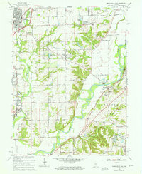 1965 Mooresville East1966 Print · USGSMid-century Morgan County is captured here as the White River corridor undergoes post-war growth. Researchers can locate family sites at Mackenzie Cem, trace the Pennsylvania RR line, or find the old Waverly Sch.3 unique versions available
 - 1965 Map of Trafalgar, 1966 Print
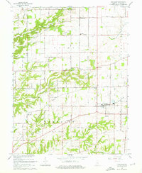 1965 Trafalgar1966 Print · USGSTrafalgar and the surrounding townships of Union and Hensley are captured here in the mid-sixties during a period of steady rural growth. Researchers can trace ancestral locations at Shiloh Cem, find the old Township Sch, or follow the path of the Old Railroad Grade.4 unique versions available
 - 1965 Map of Gosport, 1967 Print
 1965 Gosport1967 Print · USGSOwen and Monroe counties in the mid-1960s reveal a landscape defined by limestone quarrying and river commerce. Genealogists can trace family roots through sites like Van Buskirk Cem, Shiloh Ch, and the rural settlement at Highets Corner.4 unique versions available
 - 1965 Map of Martinsville, 1967 Print
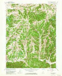
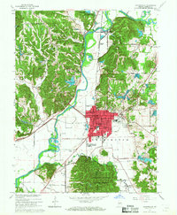 1965 Martinsville1967 Print · USGSMid-century Morgan County centers on Martinsville during a period of steady growth along the White River. Genealogists and local historians can trace family roots at Nutter Cem, visit St Martins Ch, or locate old landmarks like the Drive-in Theater.4 unique versions available
 - 1966 Map of Bridgeport, 1969 Print
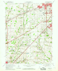 1966 Bridgeport1969 Print · USGSMarion and Hendricks counties are captured here during a period of suburban transition in the mid-1960s. Researchers can trace the layout of Weir Cook Municipal Airport and find local history at Friends Cem and West Newton.4 unique versions available
 - 1967 Map of Maywood, 1969 Print
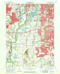 1967 Maywood1969 Print · USGSMarion County's southern industrial and residential sprawl is captured here in the late sixties as the city pushed toward the Johnson County line. Researchers can trace family roots at Indiana Central College, locate the old Union Stockyards, or find records at Calvary Cemetery.3 unique versions available
End of results
Showing maps 1-13 of 13
Top cities of Morgan County
- Martinsville historical maps
- Mooresville historical maps
- Brooklyn historical maps
- Adams historical maps
- Morgantown historical maps
- Paragon historical maps
See more
Frequently asked questions
- What are the different types of historical maps available for Morgan County?
- What is the oldest map of Morgan County?
- Where can I purchase historical maps of Morgan County for my home or office?
- Where can I download high-res historical maps of Morgan County?
- Are there historical topographic maps available for Morgan County?
- Is there historical aerial imagery available for Morgan County?
- Where are historical maps of Morgan County sourced from?