1970s Maps of Morgan County, Indiana
Explore 5 historic maps of Morgan County from the 1970s. These maps offer a rare glimpse into what life looked like during the 1970s — showing old roads, neighborhoods, homes, and landmarks that have changed or disappeared over time.
Whether you're researching your family's past, planning a metal detecting trip, or studying how Morgan County's landscape evolved across the 1970s, these high-resolution maps are a powerful tool for exploring the history of this region.
- Focus on a specific era: All maps on this page are from the 1970s, giving you a focused view of this time period.
- See what’s changed: Compare century-old streets, trails, and buildings to today's modern landscape using overlays and satellite layers.
- Research with precision: Use these maps for genealogy, historical research, land use analysis, or educational projects.
- View, download, or print: Maps are fully viewable online in high resolution, and can be downloaded or printed for your own records.
Start exploring Morgan County's history through authentic maps from the 1970s. This is your window into the past.
Morgan County, IN maps
(5)- 1970 Map of Eminence, 1972 Print
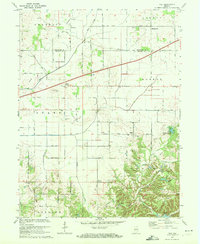
 1970 Eminence1972 Print · USGSThe crossroads of Putnam and Morgan counties are captured here in the early seventies, showing a landscape of small farming towns and rural school districts. Genealogists can locate family sites at Walnut Chapel, the Whitaker-Patrick Cem, and the historic Covered Bridge.2 unique versions available
 - 1970 Map of Modesto, 1972 Print
 1970 Modesto1972 Print · USGSThe hills of central Indiana remained a mix of dense timber and rural homesteads during the early seventies. Genealogists and local researchers can trace family landmarks like Sodom Cem, Liberty Ch, and the small settlement of Modesto.3 unique versions available
 - 1970 Map of Hall, 1972 Print
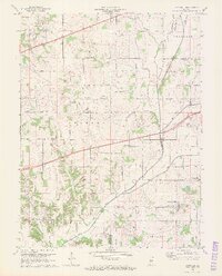
 1970 Hall1972 Print · USGSMorgan and Hendricks counties are captured here in the early 1970s, showing a landscape of small crossroads settlements and family farms. Local historians can trace established rural landmarks like Mt Pleasant Cem, the community of Hall, and Mt Moriah Ch.2 unique versions available
 - 1970 Map of Plainfield, 1972 Print
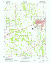 1970 Plainfield1972 Print · USGSPlainfield and the surrounding townships were rapidly evolving in the early seventies as the National Road and rail lines spurred new development. Genealogists and historians can trace family locations near Salem Ch, Spring Hill Cem, or the institutional grounds of the Indiana Boys School.3 unique versions available
 - 1970 Map of Paragon, 1972 Print
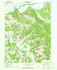
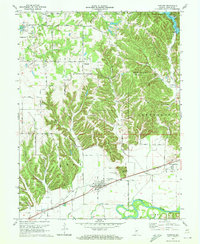 1970 Paragon1972 Print · USGSMorgan County's river-bottoms and high ridges are shown here in the 1970s, just as the local rural character remained defined by the White River. Researchers can trace old family lines through Friendship Park Cem, Lingle Cem, and small settlements like Plano and Paragon.5 unique versions available
End of results
Showing maps 1-5 of 5
Top cities of Morgan County
- Martinsville historical maps
- Mooresville historical maps
- Brooklyn historical maps
- Adams historical maps
- Morgantown historical maps
- Paragon historical maps
See more
Frequently asked questions
- What are the different types of historical maps available for Morgan County?
- What is the oldest map of Morgan County?
- Where can I purchase historical maps of Morgan County for my home or office?
- Where can I download high-res historical maps of Morgan County?
- Are there historical topographic maps available for Morgan County?
- Is there historical aerial imagery available for Morgan County?
- Where are historical maps of Morgan County sourced from?