1960s Maps of Troy, Indiana
Explore 3 historic maps of Troy from the 1960s. These maps offer a rare glimpse into what life looked like during the 1960s — showing old roads, neighborhoods, homes, and landmarks that have changed or disappeared over time.
Whether you're researching your family's past, planning a metal detecting trip, or studying how Troy's landscape evolved across the 1960s, these high-resolution maps are a powerful tool for exploring the history of this region.
- Focus on a specific era: All maps on this page are from the 1960s, giving you a focused view of this time period.
- See what’s changed: Compare century-old streets, trails, and buildings to today's modern landscape using overlays and satellite layers.
- Research with precision: Use these maps for genealogy, historical research, land use analysis, or educational projects.
- View, download, or print: Maps are fully viewable online in high resolution, and can be downloaded or printed for your own records.
Start exploring Troy's history through authentic maps from the 1960s. This is your window into the past.
Troy, IN maps
(3)- 1960 Map of Fulda, 1962 Print
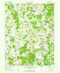 1960 Fulda1962 Print · USGSSpencer and Perry Counties are shown at the dawn of the 1960s as a landscape of tight-knit rural parishes and hilltop forests. Genealogists can trace family names through numerous remote burial grounds like Rust Cem and Butler Cem or locate old community centers such as New Boston and Fulda.3 unique versions available
 - 1961 Map of Evansville
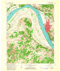
 1961 Evansville1961 Print · USGSThe Ohio River valley and its surrounding coalfields are captured here during the late fifties and early sixties. Trace the industrial rail networks of the Illinois Central RR and explore regional landmarks like Mammoth Cave National Park and Angel Mounds State Memorial.2 unique versions available
 - 1961 Map of Tell City, 1963 Print
 1961 Tell City1963 Print · USGSThe Ohio River corridor comes alive in the early sixties as industrial Tell City and Hawesville face each other across the water. Genealogists can trace family heritage through local burial grounds like Thrasher Cem and St Columba Cem or locate the site of the old Newman Sch.5 unique versions available
End of results
Showing maps 1-3 of 3
Top cities near Troy
- Tell City historical maps
- Ferdinand historical maps
- Lewisport historical maps
- Dale historical maps
- Cannelton historical maps
- Cloverport historical maps
See more
Frequently asked questions
- What are the different types of historical maps available for Troy?
- What is the oldest map of Troy?
- Where can I purchase historical maps of Troy for my home or office?
- Where can I download high-res historical maps of Troy?
- Are there historical topographic maps available for Troy?
- Is there historical aerial imagery available for Troy?
- Where are historical maps of Troy sourced from?