1900s (20th Century) Maps of Austin, Indiana
Explore 8 historic maps of Austin from the 1900s (20th Century). These maps offer a rare glimpse into what life looked like during the 1900s — showing old roads, neighborhoods, homes, and landmarks that have changed or disappeared over time.
Whether you're researching your family's past, planning a metal detecting trip, or studying how Austin's landscape evolved across the 1900s, these high-resolution maps are a powerful tool for exploring the history of this region.
- Focus on a specific era: All maps on this page are from the 1900s, giving you a focused view of this time period.
- See what’s changed: Compare century-old streets, trails, and buildings to today's modern landscape using overlays and satellite layers.
- Research with precision: Use these maps for genealogy, historical research, land use analysis, or educational projects.
- View, download, or print: Maps are fully viewable online in high resolution, and can be downloaded or printed for your own records.
Start exploring Austin's history through authentic maps from the 1900s. This is your window into the past.
Austin, IN maps
(8)- 1947 Map of Scottsburg
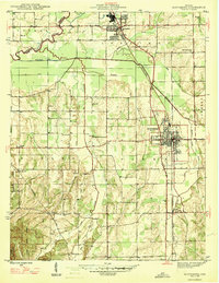 1947 Scottsburg1947 Print · USGSScott County’s agricultural and rail corridor is meticulously detailed shortly after the war, centered on the growing hubs of Scottsburg and Austin. Genealogists can locate family landmarks such as New Providence Ch, Carlisle Sch, and the COUNTY FARM.2 unique versions available
 - 1956 Map of Louisville, 1971 Print
 1956 Louisville1971 Print · USGSThe Ohio River valley and the Kentucky Bluegrass are captured here during a period of rapid mid-century growth and industrial activity. Genealogists and historians can trace rail-centered towns and military land use at Fort Knox and the Jefferson Proving Ground.2 unique versions available
 - 1959 Map of Crothersville, 1960 Print
 1959 Crothersville1960 Print · USGSSoutheast Indiana's rural landscape is captured here in the late fifties, centered on the growing community of Crothersville. Genealogists and historians can trace family roots through numerous landmarks like Marion Ch, Bethany Cem, and the small siding at Retreat.
 - 1960 Map of Scottsburg, 1961 Print
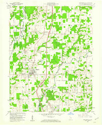
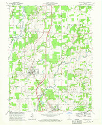
 1960 Scottsburg1961 Print · USGSScottsburg and Austin are mapped here at the dawn of the sixties, highlighting the region's rail-dependent growth and rural agricultural network. Genealogists and historians can trace family locations near Mt Zion Church, Leota, and the My Pleasant Cemetery.5 unique versions available
 - 1964 Map of Louisville
 1964 Louisville1964 Print · USGSThe Ohio River valley and Kentucky Bluegrass are captured in the mid-1960s, showing a region balanced between industrial growth and its agrarian roots. Genealogists and historians can trace the development of county seats like Shelbyville and Paris, or locate established institutions such as Georgetown College and Bernheim Forest.
 - 1968 Map of Crothersville, 1970 Print
 1968 Crothersville1970 Print · USGSSoutheastern Indiana during the late sixties shows a landscape of small towns and rail-connected farms. Genealogists can trace family landmarks like Wesley Chapel, Crothersville Cem, and the old settlement at Uniontown along the Penn Central line.2 unique versions available
 - 1986 Map of Madison
 1986 Madison1986 Print · USGSSouthern Indiana and Northern Kentucky are shown here in the mid-eighties, centered on the river corridor and the sprawling Jefferson Proving Ground. Genealogists and historians can trace rail lines like the Seaboard System and locate river towns from Madison to Bethlehem.
 - 1990 Map of Madison, 1991 Print
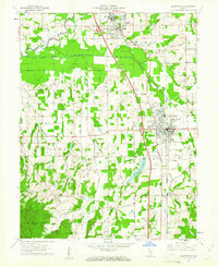
 1990 Madison1991 Print · USGSThe Ohio River valley and the southern Indiana plains are documented here in the final decade of the twentieth century. Genealogists and historians can trace family-named crossroads and established rail towns like Dudleytown, Austin, and Crothersville along the P C RR line.
End of results
Showing maps 1-8 of 8
Top cities near Austin
- Seymour historical maps
- Vienna historical maps
- Scottsburg historical maps
- Lexington historical maps
- Brownstown historical maps
- Henryville historical maps
See more
Frequently asked questions
- What are the different types of historical maps available for Austin?
- What is the oldest map of Austin?
- Where can I purchase historical maps of Austin for my home or office?
- Where can I download high-res historical maps of Austin?
- Are there historical topographic maps available for Austin?
- Is there historical aerial imagery available for Austin?
- Where are historical maps of Austin sourced from?