
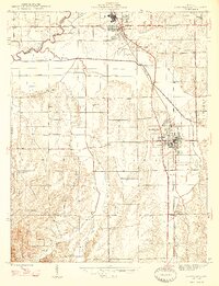
1947 Map of Scottsburg
USGS Topo · Published 1947About this map
Scottsburg serves as the focal point of this Scott County landscape, anchored by the Pennsylvania railroad line which connects the town to nearby Austin and Vienna. The mid-century topography reveals a community structured around rural institutions, including the County Farm and several local congregations such as Zion Ch, Mt Zion Ch, and Old Ox Ch. Drainage patterns are defined by a complex network of creeks, with Stucker Fork and its tributaries, including Honey Creek and Pigeon Roost Creek, winding through the terrain. In the southern portion of the map, the elevation rises toward the Clark State Forest, while the northern boundary is marked by the course of the Muscatatuck River. Small educational landmarks like Carlisle Sch and the Spurgeon Cem provide specific points of interest for those tracing family roots in the Finley and Vienna townships.
Find a feature on this map
33 named features on this map. Tap any name to fly to it.
Don’t see what you’re looking for? This feature index may not catch every label — zoom into the map to look around manually.
Map Details
Editions of this 1947 Scottsburg Map
2 editions found
Other maps of this area

1949 · Henryville
USGS Topo · 1:24,000

1955 · South Boston
USGS Topo · 1:24,000

1956 · Otisco
USGS Topo · 1:24,000

1956 · Blocher
USGS Topo · 1:24,000

1956 · Deputy
USGS Topo · 1:24,000

1956 · Louisville
USGS Topo · 1:250,000

1958 · Little York
USGS Topo · 1:24,000

1959 · Tampico
USGS Topo · 1:24,000

1959 · Crothersville
USGS Topo · 1:24,000
1960 · Henryville
USGS Topo · 1:24,000