1940s Maps of Washington County, Indiana
Explore 4 historic maps of Washington County from the 1940s. These maps offer a rare glimpse into what life looked like during the 1940s — showing old roads, neighborhoods, homes, and landmarks that have changed or disappeared over time.
Whether you're researching your family's past, planning a metal detecting trip, or studying how Washington County's landscape evolved across the 1940s, these high-resolution maps are a powerful tool for exploring the history of this region.
- Focus on a specific era: All maps on this page are from the 1940s, giving you a focused view of this time period.
- See what’s changed: Compare century-old streets, trails, and buildings to today's modern landscape using overlays and satellite layers.
- Research with precision: Use these maps for genealogy, historical research, land use analysis, or educational projects.
- View, download, or print: Maps are fully viewable online in high resolution, and can be downloaded or printed for your own records.
Start exploring Washington County's history through authentic maps from the 1940s. This is your window into the past.
Washington County, IN maps
(4)- 1941 Map of Borden
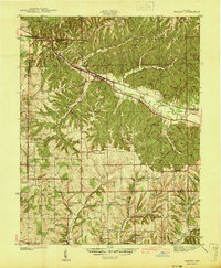 1941 Borden1941 Print · USGSIn the hills of Clark and Floyd counties just before the war, small crossroads like Navilleton and Starlight were the heart of rural life. Genealogists can trace early homesteads through family landmarks like Fisher Cem and Goss Sch near the Muddy Fork railroad line.
 - 1947 Map of Hardinsburg, 1966 Print
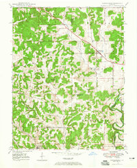 1947 Hardinsburg1966 Print · USGSSouthern Indiana's rural landscape is captured here in the late 1940s, showing a patchwork of small farms and family-named creek crossings. Genealogists can trace family roots at Oak Grove Ch, Walton Cem, and early schools like School No 6.
 - 1949 Map of Hardinsburg
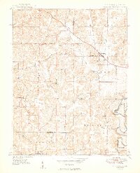 1949 Hardinsburg1949 Print · USGSSouthern Indiana at the end of the 1940s reveals a patchwork of rural school districts and county-line settlements. Genealogists can trace family footprints across Hardinsburg and Marengo or find ancestral sites like Old Unity Cem and Baptist Hill Ch.2 unique versions available
 - 1949 Map of Henryville
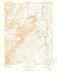 1949 Henryville1949 Print · USGSSouthern Indiana's timbered hills and rural townships are captured here just after the war, showing the deep integration of state conservation and local settlement. Trace family roots at Mt Zion Ch and Mountain Grove Cem, or follow the Pennsylvania rail line through Henryville and Underwood.2 unique versions available
End of results
Showing maps 1-4 of 4
Top cities of Washington County
- Salem historical maps
- New Pekin historical maps
- Campbellsburg historical maps
- Hardinsburg historical maps
- Little York historical maps
- Livonia historical maps
See more
Frequently asked questions
- What are the different types of historical maps available for Washington County?
- What is the oldest map of Washington County?
- Where can I purchase historical maps of Washington County for my home or office?
- Where can I download high-res historical maps of Washington County?
- Are there historical topographic maps available for Washington County?
- Is there historical aerial imagery available for Washington County?
- Where are historical maps of Washington County sourced from?