1970s Maps of Washington County, Indiana
Explore 2 historic maps of Washington County from the 1970s. These maps offer a rare glimpse into what life looked like during the 1970s — showing old roads, neighborhoods, homes, and landmarks that have changed or disappeared over time.
Whether you're researching your family's past, planning a metal detecting trip, or studying how Washington County's landscape evolved across the 1970s, these high-resolution maps are a powerful tool for exploring the history of this region.
- Focus on a specific era: All maps on this page are from the 1970s, giving you a focused view of this time period.
- See what’s changed: Compare century-old streets, trails, and buildings to today's modern landscape using overlays and satellite layers.
- Research with precision: Use these maps for genealogy, historical research, land use analysis, or educational projects.
- View, download, or print: Maps are fully viewable online in high resolution, and can be downloaded or printed for your own records.
Start exploring Washington County's history through authentic maps from the 1970s. This is your window into the past.
Washington County, IN maps
(2)- 1970 Map of Campbellsburg, 1972 Print
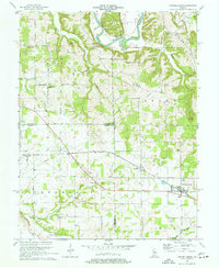 1970 Campbellsburg1972 Print · USGSSouthern Indiana rail and river life converge here during the early seventies, centered on the MONON line. Researchers can trace the layout of small settlements like Saltillo and Campbellsburg or locate rural landmarks like Fishing Creek Chapel and Freedom Cem.2 unique versions available
 - 1970 Map of Livonia, 1972 Print
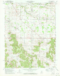 1970 Livonia1972 Print · USGSIndiana's limestone country in the early seventies reveals a landscape of sinking streams and rural crossroads. Genealogists can trace family roots through landmarks like Lost River Ch, Posey Chapel, and the small settlement of Bromer.
End of results
Showing maps 1-2 of 2
Top cities of Washington County
- Salem historical maps
- New Pekin historical maps
- Campbellsburg historical maps
- Hardinsburg historical maps
- Little York historical maps
- Livonia historical maps
See more
Frequently asked questions
- What are the different types of historical maps available for Washington County?
- What is the oldest map of Washington County?
- Where can I purchase historical maps of Washington County for my home or office?
- Where can I download high-res historical maps of Washington County?
- Are there historical topographic maps available for Washington County?
- Is there historical aerial imagery available for Washington County?
- Where are historical maps of Washington County sourced from?