1960s Maps of Washington County, Indiana
Explore 10 historic maps of Washington County from the 1960s. These maps offer a rare glimpse into what life looked like during the 1960s — showing old roads, neighborhoods, homes, and landmarks that have changed or disappeared over time.
Whether you're researching your family's past, planning a metal detecting trip, or studying how Washington County's landscape evolved across the 1960s, these high-resolution maps are a powerful tool for exploring the history of this region.
- Focus on a specific era: All maps on this page are from the 1960s, giving you a focused view of this time period.
- See what’s changed: Compare century-old streets, trails, and buildings to today's modern landscape using overlays and satellite layers.
- Research with precision: Use these maps for genealogy, historical research, land use analysis, or educational projects.
- View, download, or print: Maps are fully viewable online in high resolution, and can be downloaded or printed for your own records.
Start exploring Washington County's history through authentic maps from the 1960s. This is your window into the past.
Washington County, IN maps
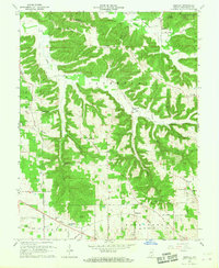
(10)- 1960 Map of Henryville, 1961 Print
 1960 Henryville1961 Print · USGSSouthern Indiana's knobs and forest lands are captured here just as modern conservation efforts and rail transit shaped the local landscape. Genealogists can locate family landmarks like New Chapel Ch, Mt Zion Cem, and the historic Pigeon Roost Memorial.4 unique versions available
 - 1963 Map of Salem, 1965 Print
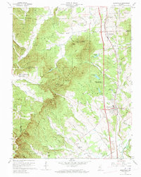
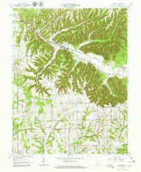
 1963 Salem1965 Print · USGSSouthern Indiana's landscape is captured here in the early sixties, showing the vital corridors of the MONON railroad and the Blue River. Researchers can trace local heritage through sites like Crown Hill Cem, College Hill Ch, and the rural Farabee settlement.4 unique versions available
 - 1963 Map of Kossuth, 1965 Print
 1963 Kossuth1965 Print · USGSSouthern Indiana ridge country comes alive in the mid-1960s, showing a landscape defined by state forest land and tight-knit rural communities. Trace family history through Plattsburg and Kossuth, or locate ancestral sites like Paugh Cem and Township Sch.3 unique versions available
 - 1964 Map of Louisville
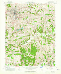
 1964 Louisville1964 Print · USGSThe Ohio River valley and Kentucky Bluegrass are captured in the mid-1960s, showing a region balanced between industrial growth and its agrarian roots. Genealogists and historians can trace the development of county seats like Shelbyville and Paris, or locate established institutions such as Georgetown College and Bernheim Forest.
 - 1966 Map of Palmyra, 1968 Print
 1966 Palmyra1968 Print · USGSSouthern Indiana's rolling farmland and river valleys are captured in the mid-sixties, highlighting the rural transition between Washington and Harrison Counties. Genealogists and historians can trace the Old Indian Treaty Boundary and locate family landmarks like Snyders Chapel Cem or Rickard Cem.3 unique versions available
 - 1966 Map of Smedley, 1968 Print
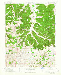
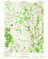
 1966 Smedley1968 Print · USGSMid-century Washington County is captured here during a time of active rail transport and established rural communities. Genealogists and historians can trace family roots through numerous sites like Old Smedley Cem, the rail stop at Hitchcock, and schools like Haley sburg Sch.3 unique versions available
 - 1966 Map of Becks Mill, 1968 Print
 1966 Becks Mill1968 Print · USGSWashington County mid-century life is captured here as the city of Salem expands toward the Salem Speedway. Local historians can trace family locations near Becks Mill, Rosebud, or the many rural churches like Kansas Ch and Mount Tabor Ch.2 unique versions available
 - 1966 Map of Hardinsburg, 1968 Print
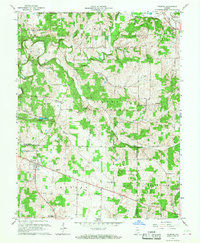
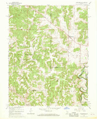 1966 Hardinsburg1968 Print · USGSSouthern Indiana's rural landscape is captured in the mid-sixties, showing the transition from agricultural tracts to protected woodlands. Genealogists can trace family sites at Baptist Hill Ch, Old Unity Ch, and the crossing at Totten Ford Bridge.2 unique versions available
 - 1966 Map of Fredericksburg, 1968 Print
 1966 Fredericksburg1968 Print · USGSThe Blue River corridor in the mid-1960s reveals a landscape shaped by early surveyors and local industry. Genealogists can trace family roots through many rural landmarks, including McIntosh Mill, Kays Chapel, and the historic INDIAN TREATY BOUNDARY.3 unique versions available
 - 1966 Map of Borden, 1968 Print
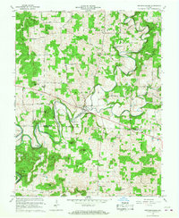
 1966 Borden1968 Print · USGSBorden and the surrounding hills of Clark and Floyd counties are shown here during the mid-1960s. Genealogists and local historians can trace family locations along the Monon Railroad and identify sites like St Johns School, Mt Eden Cemetery, and Navilleton.5 unique versions available
End of results
Showing maps 1-10 of 10
Top cities of Washington County
- Salem historical maps
- New Pekin historical maps
- Campbellsburg historical maps
- Hardinsburg historical maps
- Little York historical maps
- Livonia historical maps
See more
Frequently asked questions
- What are the different types of historical maps available for Washington County?
- What is the oldest map of Washington County?
- Where can I purchase historical maps of Washington County for my home or office?
- Where can I download high-res historical maps of Washington County?
- Are there historical topographic maps available for Washington County?
- Is there historical aerial imagery available for Washington County?
- Where are historical maps of Washington County sourced from?