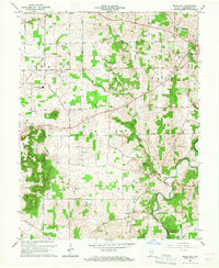
1966 Map of Becks Mill
USGS Topo · Published 1968About this map
Becks Mill and the surrounding townships of Vernon and Washington characterize this mid-century portrait of southern Indiana. The landscape is defined by the winding course of the Blue River and its tributaries, including Sulphur Springs Creek and Mill Creek. This era of development is evidenced by the prominent presence of the Salem Speedway and Salem Municipal Airport on the edge of Salem, contrasting with the more rural character of Smedley and Rosebud.
Find a feature on this map
40 named features on this map. Tap any name to fly to it.
Don’t see what you’re looking for? This feature index may not catch every label — zoom into the map to look around manually.
Map Details
Editions of this 1966 Becks Mill Map
2 editions found
Other maps of this area

1947 · Hardinsburg
USGS Topo · 1:24,000

1949 · Hardinsburg
USGS Topo · 1:24,000

1950 · Salem
USGS Topo · 1:24,000

1950 · Becks Mill
USGS Topo · 1:24,000

1950 · Palmyra
USGS Topo · 1:24,000

1951 · Smedley
USGS Topo · 1:24,000

1953 · Fredericksburg
USGS Topo · 1:24,000

1953 · Kossuth
USGS Topo · 1:24,000

1956 · Vincennes
USGS Topo · 1:250,000

1957 · Vincennes
USGS Topo · 1:250,000