
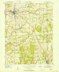
1950 Map of Salem
USGS Topo · Published 1950About this map
The county seat of Salem serves as the focal point for this mid-century Indiana landscape, where the Chicago Indianapolis and Louisville railroad cuts a diagonal path through the countryside. The geography is defined by the branching waterways of the Blue River, including the West Fork Blue River and Middle Fork Blue River. These waters supported local recreation and infrastructure, seen in the development of Lake Salinda and the municipal Reservoir near the city center.
Find a feature on this map
39 named features on this map. Tap any name to fly to it.
Don’t see what you’re looking for? This feature index may not catch every label — zoom into the map to look around manually.
Map Details
Editions of this 1950 Salem Map
2 editions found
Other maps of this area

1941 · Borden
USGS Topo · 1:24,000

1950 · Becks Mill
USGS Topo · 1:24,000

1950 · Palmyra
USGS Topo · 1:24,000

1951 · Smedley
USGS Topo · 1:24,000

1953 · Fredericksburg
USGS Topo · 1:24,000

1953 · Kossuth
USGS Topo · 1:24,000

1955 · South Boston
USGS Topo · 1:24,000

1956 · Vincennes
USGS Topo · 1:250,000

1956 · Louisville
USGS Topo · 1:250,000

1957 · Vincennes
USGS Topo · 1:250,000