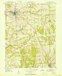
1950 Map of Salem
USGS Topo · Published 1950About this map
Salem serves as the central hub of this 1950 Washington County survey, where the convergence of the West Fork Blue River and several local brooks supported a growing community. The map details the local infrastructure of the mid-century era, including the Fairgrounds and the Sewage Disposal plant. Further south, the creation of Lake Salinda by the damming of the Hoggatt Branch illustrates significant water management and recreation development.
Find a feature on this map
40 named features on this map. Tap any name to fly to it.
Don’t see what you’re looking for? This feature index may not catch every label — zoom into the map to look around manually.
Map Details
Editions of this 1950 Salem Map
2 editions found
Other maps of this area

1941 · Borden
USGS Topo · 1:24,000

1950 · Salem
USGS Topo · 1:24,000

1950 · Becks Mill
USGS Topo · 1:24,000

1950 · Palmyra
USGS Topo · 1:24,000

1951 · Smedley
USGS Topo · 1:24,000

1953 · Fredericksburg
USGS Topo · 1:24,000

1953 · Kossuth
USGS Topo · 1:24,000

1955 · South Boston
USGS Topo · 1:24,000

1956 · Vincennes
USGS Topo · 1:250,000

1956 · Louisville
USGS Topo · 1:250,000