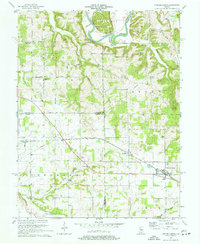
1970 Map of Campbellsburg
USGS Topo · Published 1972About this map
The Monon railroad corridor defines the development of this southern Indiana landscape, connecting the primary settlements of Campbellsburg and Saltillo during the early 1970s. The terrain transitions from the concentrated rail-town grids to the winding paths of the East Fork White River in the north, where it creates the prominent Horseshoe Bend near the small community of Bono. This survey captures a rural environment deeply rooted in community landmarks, particularly evident in the distribution of country churches and family-named cemeteries such as Fishing Creek Chapel, Sugar Creek Ch, and the Talbott Cem. The inclusion of various watercourses like Carters Creek, Twin Creek, and the Lost River suggests a well-watered agricultural region, while the presence of pipelines cutting across the townships of Bono, Brown, and Vernon indicates the modernization of utility infrastructure through the forest and farmland.
Find a feature on this map
39 named features on this map. Tap any name to fly to it.
Don’t see what you’re looking for? This feature index may not catch every label — zoom into the map to look around manually.
Map Details
Editions of this 1970 Campbellsburg Map
2 editions found
Other maps of this area

1934 · Bedford
USGS Topo · 1:48,000

1937 · Bedford
USGS Topo · 1:62,500

1950 · Becks Mill
USGS Topo · 1:24,000

1950 · Mitchell
USGS Topo · 1:24,000

1951 · Smedley
USGS Topo · 1:24,000

1956 · Vincennes
USGS Topo · 1:250,000

1957 · Vincennes
USGS Topo · 1:250,000

1957 · Campbellsburg
USGS Topo · 1:24,000

1957 · Livonia
USGS Topo · 1:24,000
1957 · Paoli
USGS Topo · 1:24,000