1910s Maps of Marion County, Iowa
Explore 5 historic maps of Marion County from the 1910s. These maps offer a rare glimpse into what life looked like during the 1910s — showing old roads, neighborhoods, homes, and landmarks that have changed or disappeared over time.
Whether you're researching your family's past, planning a metal detecting trip, or studying how Marion County's landscape evolved across the 1910s, these high-resolution maps are a powerful tool for exploring the history of this region.
- Focus on a specific era: All maps on this page are from the 1910s, giving you a focused view of this time period.
- See what’s changed: Compare century-old streets, trails, and buildings to today's modern landscape using overlays and satellite layers.
- Research with precision: Use these maps for genealogy, historical research, land use analysis, or educational projects.
- View, download, or print: Maps are fully viewable online in high resolution, and can be downloaded or printed for your own records.
Start exploring Marion County's history through authentic maps from the 1910s. This is your window into the past.
Marion County, IA maps
(5)- 1910 Map of Milo
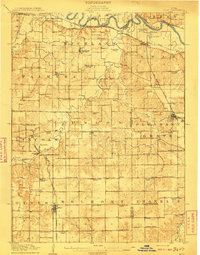 1910 Milo1910 Print · USGSWarren and Marion counties are captured here at the height of their early 20th-century rural development, before the modernization of the road network. Genealogists can trace family footprints through numerous country schools like Prairie Creek School and the river-crossing at Hammondsburg Bridge.2 unique versions available
 - 1910 Map of Pella, 1958 Print
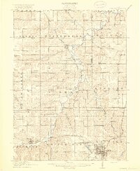
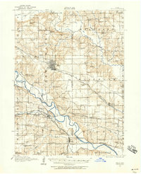 1910 Pella1958 Print · USGSMarion and Mahaska counties at the peak of the rail era show a landscape dotted with country schools and river settlements. Genealogists and historians can locate vanished schoolhouses like Bunker Hill School and trace the paths of the Chicago Rock Island and Pacific through Pella and Leighton.2 unique versions available
 - 1912 Map of Knoxville
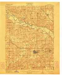 1912 Knoxville1912 Print · USGSMarion County at the dawn of the twentieth century was a landscape of bustling rail towns and river crossings. Genealogists can trace the exact locations of dozens of rural schoolhouses and churches like Stringtown School and Mt Vernon Church alongside the Des Moines River.2 unique versions available
 - 1912 Map of Pella
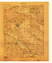 1912 Pella1912 Print · USGSThe river valleys of Marion County come alive in this pre-World War I portrait of a thriving agricultural and rail corridor. Researchers can pinpoint early homesteads near dozens of rural landmarks, including Pella, Salem Church, and the West Amsterdam School.2 unique versions available
 - 1918 Map of Chariton
 1918 Chariton1918 Print · USGSChariton and its neighboring townships thrive as a rail-connected agricultural hub during the late First World War era. Trace family roots at Chariton or locate rural landmarks like Indianola Junction and the Horstman School.4 unique versions available
End of results
Showing maps 1-5 of 5
Frequently asked questions
- What are the different types of historical maps available for Marion County?
- What is the oldest map of Marion County?
- Where can I purchase historical maps of Marion County for my home or office?
- Where can I download high-res historical maps of Marion County?
- Are there historical topographic maps available for Marion County?
- Is there historical aerial imagery available for Marion County?
- Where are historical maps of Marion County sourced from?