1960s Maps of Marion County, Iowa
Explore 9 historic maps of Marion County from the 1960s. These maps offer a rare glimpse into what life looked like during the 1960s — showing old roads, neighborhoods, homes, and landmarks that have changed or disappeared over time.
Whether you're researching your family's past, planning a metal detecting trip, or studying how Marion County's landscape evolved across the 1960s, these high-resolution maps are a powerful tool for exploring the history of this region.
- Focus on a specific era: All maps on this page are from the 1960s, giving you a focused view of this time period.
- See what’s changed: Compare century-old streets, trails, and buildings to today's modern landscape using overlays and satellite layers.
- Research with precision: Use these maps for genealogy, historical research, land use analysis, or educational projects.
- View, download, or print: Maps are fully viewable online in high resolution, and can be downloaded or printed for your own records.
Start exploring Marion County's history through authentic maps from the 1960s. This is your window into the past.
Marion County, IA maps
(9)- 1965 Map of Pleasantville, 1966 Print
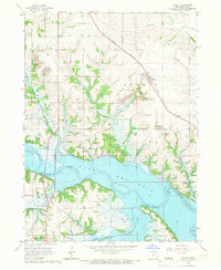
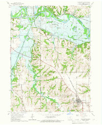 1965 Pleasantville1966 Print · USGSIn the mid-1960s, this portion of Marion County was undergoing significant hydrological change as the reservoir system began to shape the river valleys. Researchers can trace the paths of three major rail lines and locate local landmarks like Swan Cem, the Scatling Mine, and the village of Beech.
 - 1965 Map of Prairie City, 1966 Print
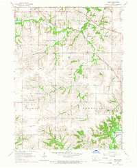
 1965 Prairie City1966 Print · USGSPrairie City and the surrounding Jasper County townships are shown in the mid-sixties as the landscape transitioned with new infrastructure and water management. Genealogists can locate family sites at Waveland Cem, Griffis Cem, and the Church of the Brethren.
 - 1965 Map of Knoxville NW, 1966 Print
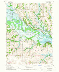 1965 Knoxville NW1966 Print · USGSThe Des Moines River valley in Marion County is captured here just as the landscape was being reshaped by the reservoir. Genealogists and local historians can locate several burial sites, including Dunreath Cem and Rees Cem, alongside an Old Railroad Grade and numerous creek beds.
 - 1965 Map of Monroe, 1966 Print
 1965 Monroe1966 Print · USGSJasper County farming communities thrive along the river during the mid-sixties as new road infrastructure begins to take shape. Genealogists can trace family roots through several local landmarks like Tools Chapel, Warren Grove Sch, and Gifford Cem.2 unique versions available
 - 1965 Map of Otley, 1966 Print
 1965 Otley1966 Print · USGSMarion County underwent a massive transformation in the mid-sixties as the Des Moines River valley prepared for the rising waters of Red Rock Lake. Researchers can trace the original landscape through family cemeteries like Ruckman Cem and the small settlement of Teter.2 unique versions available
 - 1965 Map of Knoxville SW, 1966 Print
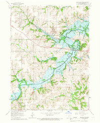 1965 Knoxville SW1966 Print · USGSMarion County comes into focus in the mid-sixties as the newly formed waters of Lake Red Rock reshape the landscape. Researchers can trace the legacy of early settlers and miners at Lincoln Cem, the village of Donnelley, and several local Strip Mines.
 - 1965 Map of Beech, 1966 Print
 1965 Beech1966 Print · USGSMarion County farming communities and rail lines are documented here in the mid-1960s, just as regional water management began altering the landscape. Genealogists can locate family landmarks like Highland Cem, Motor Ch, and the rural settlements of Beech and Caloma.
 - 1965 Map of Knoxville, 1966 Print
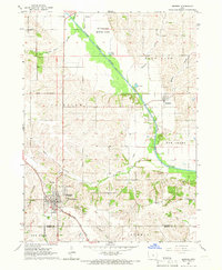
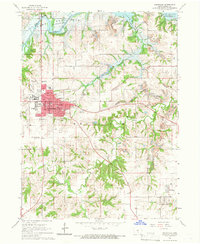 1965 Knoxville1966 Print · USGSKnoxville and its surrounding coalfields are captured in the mid-sixties, just as the landscape was being reshaped by the rising waters of Lake Red Rock. Researchers can trace the era's industry and community through numerous Strip Mines and rural landmarks like Zion Ch and Graceland Cem.2 unique versions available
 - 1969 Map of Des Moines
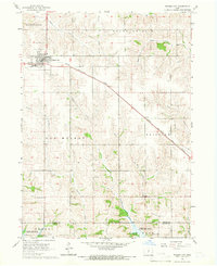
 1969 Des Moines1969 Print · USGSCentral Iowa's fertile plains and growing capital are captured here during the late sixties, a time of major highway expansion and reservoir construction. Genealogists and researchers can trace rural township boundaries, local cemeteries, and rail lines serving towns like Pella, Grinnell, and Oskaloosa.
End of results
Showing maps 1-9 of 9
Frequently asked questions
- What are the different types of historical maps available for Marion County?
- What is the oldest map of Marion County?
- Where can I purchase historical maps of Marion County for my home or office?
- Where can I download high-res historical maps of Marion County?
- Are there historical topographic maps available for Marion County?
- Is there historical aerial imagery available for Marion County?
- Where are historical maps of Marion County sourced from?