1980s Maps of Marion County, Iowa
Explore 15 historic maps of Marion County from the 1980s. These maps offer a rare glimpse into what life looked like during the 1980s — showing old roads, neighborhoods, homes, and landmarks that have changed or disappeared over time.
Whether you're researching your family's past, planning a metal detecting trip, or studying how Marion County's landscape evolved across the 1980s, these high-resolution maps are a powerful tool for exploring the history of this region.
- Focus on a specific era: All maps on this page are from the 1980s, giving you a focused view of this time period.
- See what’s changed: Compare century-old streets, trails, and buildings to today's modern landscape using overlays and satellite layers.
- Research with precision: Use these maps for genealogy, historical research, land use analysis, or educational projects.
- View, download, or print: Maps are fully viewable online in high resolution, and can be downloaded or printed for your own records.
Start exploring Marion County's history through authentic maps from the 1980s. This is your window into the past.
Marion County, IA maps
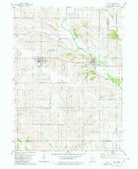
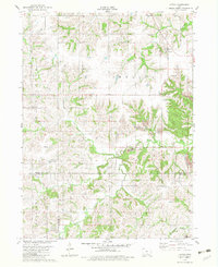
(15)- 1980 Map of Leighton
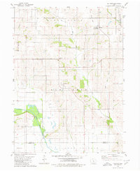
 1980 Leighton1980 Print · USGSMahaska County as it appeared in the late 1970s shows a landscape of river bends and active industrial sites. Researchers can trace the rail line through Leighton or locate family plots at Butler Cem and Sand Ridge Cem.
 - 1980 Map of Sully
 1980 Sully1980 Print · USGSCentral Iowa farmland meets the North Skunk River in the early eighties, centered on the growing communities of Sully and Lynnville. Researchers can locate numerous family burial grounds like Swans Cem and Dairy Grove Cem, along with local landmarks like the Municipal Landing Strip.
 - 1980 Map of Peoria
 1980 Peoria1980 Print · USGSMahaska County and Marion County farmlands are captured in the late seventies, showing the transition of rural Iowa townships. Genealogists and historians can trace family roots through landmarks like Appel Cem, the Christian Sch, and the South Skunk River.
 - 1980 Map of Pella
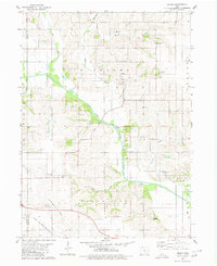
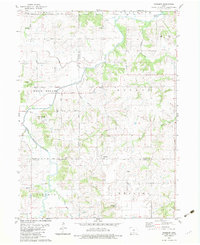
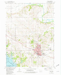 1980 Pella1980 Print · USGSPella and the surrounding Marion County farmlands are captured in the early eighties, showcasing a landscape shaped by Dutch heritage and river geography. Genealogists and historians can trace institutional roots at the Central Univ of Iowa, locate family plots at Oak Wood Cem, or follow the Chicago Rock Island and Pacific rail line.
 - 1980 Map of Killduff
 1980 Killduff1980 Print · USGSJasper County agricultural life and river geography are documented here during the late twentieth century. Genealogists and researchers can trace rural landmarks like St Andrews Ch, Hewitt Cem, and the small community of Galesburg.
 - 1980 Map of Harvey
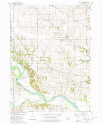
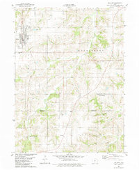
 1980 Harvey1980 Print · USGSMarion County's river valley is captured here in the late seventies, showing the rail-and-river economy near Harvey. Genealogists can trace family locations through several rural cemeteries like Eureka Cem and Brecke Ridge Cem or the small settlement of Tracy.
 - 1982 Map of Oskaloosa
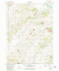
 1982 Oskaloosa1982 Print · USGSSoutheast Iowa's river valleys and rail hubs are meticulously detailed in the early eighties, showing a landscape of productive farmland and growing municipal centers. Researchers can trace the legacy of small-town life and local industry through features like Union Mills, What Cheer, and the extensive Burlington Northern rail network.
 - 1982 Map of Buxton, 1983 Print
 1982 Buxton1983 Print · USGSMahaska and Monroe counties are seen here in the early 1980s, where the legacy of Iowa coal mining is etched across the terrain. Researchers can locate the site of Buxton, trace an Old Railroad Grade, or find family names at Weldon Cem and Union Liberty Ch.
 - 1982 Map of Lovilia, 1983 Print
 1982 Lovilia1983 Print · USGSThe Marion and Monroe county border was defined by heavy industry and small-town life in the early eighties. Genealogists can trace family burial sites at Woodlawn Cem and Greenlawn Cem while exploring the impact of Strip Mines on Lovilia and Bussey.
 - 1982 Map of Attica, 1983 Print
 1982 Attica1983 Print · USGSThe rural landscape of Marion County in the early eighties reveals a mix of upland farming and active industrial sites. Genealogists can locate several family cemeteries such as Hogeland Cem and Oak Dale Cem, while researchers can trace local coal history through the Strip Mines near Indiana Chapel.
 - 1982 Map of Melcher, 1983 Print
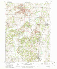
 1982 Melcher1983 Print · USGSMarion County agriculture and small-town life are captured here in the early eighties as the settlements of Melcher and Dallas thrive. Local researchers can trace family landmarks like Sacred Heart Ch, Columbia Cem, and the community of Gosport.
 - 1982 Map of Newbern, 1983 Print
 1982 Newbern1983 Print · USGSThe crossroads of Marion and Warren counties are captured here in the early eighties, showcasing a landscape of established family farms. Genealogists can trace local roots through numerous sites like St Paul Cem, Newbern Cem, and the community of Bauer.
 - 1984 Map of Indianola
 1984 Indianola1984 Print · USGSSouth-central Iowa in the mid-1980s reveals a patchwork of established rail hubs and significant new conservation areas. Trace the Chicago and North Western rail lines and explore rural landmarks like Lake Ahquabi State Park or the Strip Mine near Knoxville.
 - 1984 Map of Des Moines, 1985 Print
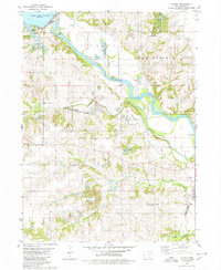
 1984 Des Moines1985 Print · USGSCentral Iowa's heartland is captured in the mid-1980s as suburban growth met long-standing farm and rail infrastructure. Genealogists and researchers can trace the reaches of the Chicago and North Western through Maxwell or locate Laurel Hill Cem and Camp Dodge Military Reservation.2 unique versions available
 - 1984 Map of Grinnell, 1985 Print
 1984 Grinnell1985 Print · USGSCentral Iowa's prairie towns and rail corridors are captured in the mid-1980s, showcasing the agricultural grid and protected marshlands. Researchers can trace historic routes along the Chicago and North Western or locate family roots near the Sac and Fox Indian Reservation and Lake Ponderosa.2 unique versions available
End of results
Showing maps 1-15 of 15
Frequently asked questions
- What are the different types of historical maps available for Marion County?
- What is the oldest map of Marion County?
- Where can I purchase historical maps of Marion County for my home or office?
- Where can I download high-res historical maps of Marion County?
- Are there historical topographic maps available for Marion County?
- Is there historical aerial imagery available for Marion County?
- Where are historical maps of Marion County sourced from?