1920s Maps of Marion County, Iowa
Explore 2 historic maps of Marion County from the 1920s. These maps offer a rare glimpse into what life looked like during the 1920s — showing old roads, neighborhoods, homes, and landmarks that have changed or disappeared over time.
Whether you're researching your family's past, planning a metal detecting trip, or studying how Marion County's landscape evolved across the 1920s, these high-resolution maps are a powerful tool for exploring the history of this region.
- Focus on a specific era: All maps on this page are from the 1920s, giving you a focused view of this time period.
- See what’s changed: Compare century-old streets, trails, and buildings to today's modern landscape using overlays and satellite layers.
- Research with precision: Use these maps for genealogy, historical research, land use analysis, or educational projects.
- View, download, or print: Maps are fully viewable online in high resolution, and can be downloaded or printed for your own records.
Start exploring Marion County's history through authentic maps from the 1920s. This is your window into the past.
Marion County, IA maps
(2)- 1924 Map of Melcher
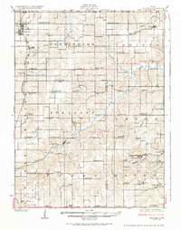 1924 Melcher1924 Print · USGSSouth-central Iowa thrives during the 1920s coal boom, where rail lines and mine shafts transformed the rural landscape. Trace the growth of mining towns like Tipperary and Bucknell, and locate vanished local schools such as Coal Glen School.3 unique versions available
 - 1929 Map of Albia
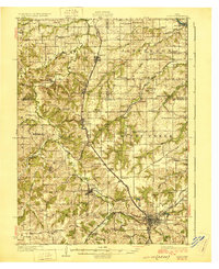 1929 Albia1929 Print · USGSMonroe County was a bustling coal and rail corridor during the late twenties, anchored by the junction at Albia. Genealogists and historians can trace defunct mining camps like Hiteman and dozens of rural school sites such as Halfway Prairie Sch.3 unique versions available
End of results
Showing maps 1-2 of 2
Frequently asked questions
- What are the different types of historical maps available for Marion County?
- What is the oldest map of Marion County?
- Where can I purchase historical maps of Marion County for my home or office?
- Where can I download high-res historical maps of Marion County?
- Are there historical topographic maps available for Marion County?
- Is there historical aerial imagery available for Marion County?
- Where are historical maps of Marion County sourced from?