1960s Maps of Chautauqua County, Kansas
Explore 19 historic maps of Chautauqua County from the 1960s. These maps offer a rare glimpse into what life looked like during the 1960s — showing old roads, neighborhoods, homes, and landmarks that have changed or disappeared over time.
Whether you're researching your family's past, planning a metal detecting trip, or studying how Chautauqua County's landscape evolved across the 1960s, these high-resolution maps are a powerful tool for exploring the history of this region.
- Focus on a specific era: All maps on this page are from the 1960s, giving you a focused view of this time period.
- See what’s changed: Compare century-old streets, trails, and buildings to today's modern landscape using overlays and satellite layers.
- Research with precision: Use these maps for genealogy, historical research, land use analysis, or educational projects.
- View, download, or print: Maps are fully viewable online in high resolution, and can be downloaded or printed for your own records.
Start exploring Chautauqua County's history through authentic maps from the 1960s. This is your window into the past.
Chautauqua County, KS maps
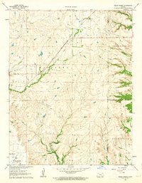
(19)- 1961 Map of Caney, 1963 Print
 1961 Caney1963 Print · USGSMontgomery County was a landscape of rail-driven commerce and emerging industry in the early sixties. Genealogists and local historians can trace the Old Indian Treaty Boundary, the Sunny Side Cem, and mid-century relics like the Drive-in Theater.3 unique versions available
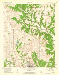
 - 1962 Map of Oak Valley, 1963 Print
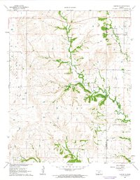
 1962 Oak Valley1963 Print · USGSElk County and Chautauqua County rural life is captured here in the early sixties, centered on the Elk River and rail corridors. Genealogists and researchers can locate the Crum Cem, trace the Atchison Topeka and Santa Fe River line, or explore the streets of Longton and Oak Valley.2 unique versions available
 - 1962 Map of Cedar Vale West, 1963 Print
 1962 Cedar Vale West1963 Print · USGSCowley County in the early 1960s reveals a landscape shaped by rail, ranching, and the legacy of the Old Indian Treaty Boundary. Genealogists and historians can trace family roots through the Cedar Creek Cem or locate the industrial footprint of local Oil Wells and the Missouri Pacific line.2 unique versions available
 - 1962 Map of Moline, 1963 Print
 1962 Moline1963 Print · USGSMoline and the surrounding ranching country of Elk and Chautauqua Counties are captured here in the early sixties. Genealogists and local historians can trace family roots at Belknap Ch, Ames Cem, and along the Atchison Topeka and Santa Fe rail line.2 unique versions available
 - 1962 Map of Elk Falls, 1963 Print
 1962 Elk Falls1963 Print · USGSElk Falls and the surrounding Kansas prairie are captured in the early sixties as the railroad still actively served the river valley. Genealogists and historians can trace the Atchison Topeka and Santa Fe rail line, early Oil Wells, and the rural boundary of Elk and Chautauqua counties.2 unique versions available
 - 1962 Map of Grand Summit, 1963 Print
 1962 Grand Summit1963 Print · USGSThe Flint Hills on the Cowley and Elk County border appear here in the early sixties, defined by cattle country and energy production. Genealogists and researchers can locate Gospel Ridge Cem and trace the Atchison Topeka and Santa Fe rail line through Grand Summit.2 unique versions available
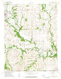
 - 1962 Map of Sedan, 1963 Print
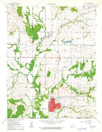
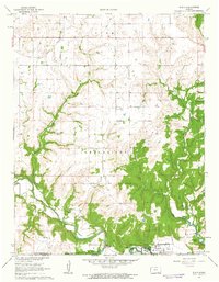
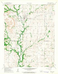
 1962 Sedan1963 Print · USGSChautauqua County’s rural character and industrial energy are captured in the early sixties as the oil economy shaped the prairie. Researchers can locate family landmarks like Union Chapel, St Charles Cem, and the old Missouri Pacific rail line.3 unique versions available
 - 1962 Map of Cedar Vale East, 1963 Print
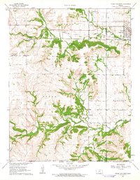
 1962 Cedar Vale East1963 Print · USGSChautauqua County’s borderlands come into focus in the early sixties as the Caney River valley transitions into the Oklahoma panhandle. Genealogists and historians can trace the Old Indian Treaty Boundary and locate Osro Falls Cem or the rail-stop at Hewins.3 unique versions available
 - 1962 Map of Elgin NE, 1963 Print
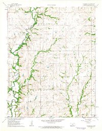
 1962 Elgin NE1963 Print · USGSChautauqua County land is documented here in the early sixties as the oil and rail economy shaped the rural landscape. Genealogists and local historians can locate family burial sites like Spring Creek Cem and Rogers Cem, or trace the winding Middle Caney River to Butcher Falls.2 unique versions available
 - 1962 Map of Elgin, 1963 Print
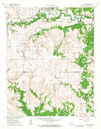
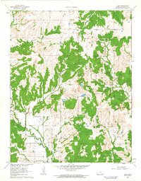
 1962 Elgin1963 Print · USGSElgin and the Chautauqua County borderlands are documented here in the early 1960s, just as the Hulah Res shaped the local hydrology. Genealogists can trace family roots at Moore Prairie Cem or follow the Old Indian Treaty Boundary across the Caney River.3 unique versions available
 - 1962 Map of Hale, 1963 Print
 1962 Hale1963 Print · USGSChautauqua County in the early sixties reveals a landscape shaped by early transit and energy extraction. Trace the remnants of the Old Railroad Grade, locate the historic California Road, and find family sites at Hale Cem or Riley Cem.2 unique versions available
 - 1962 Map of Cloverdale, 1963 Print
 1962 Cloverdale1963 Print · USGSChautauqua County farm country is mapped in the early sixties as a network of creek-bottom roads and small rural townships. Genealogists can trace family footprints near Cloverdale, Round Mound Ch, and the Old Cloverdale Cem.2 unique versions available
 - 1962 Map of Peru, 1963 Print
 1962 Peru1963 Print · USGSSoutheast Kansas at the start of the 1960s reveals a landscape defined by petroleum extraction and old territorial lines. Genealogists can locate several burial grounds like Booth Cem and Elcado Cem while tracing the path of the Missouri Pacific Railroad.2 unique versions available
 - 1962 Map of Dexter NE, 1963 Print
 1962 Dexter NE1963 Print · USGSSoutheastern Kansas ranching country is meticulously detailed in the early 1960s as it transitions into a modern era of agriculture. Researchers can locate specific family landmarks such as the Boone Ranch, McCoy Ranch, and a small local Cem.2 unique versions available
 - 1962 Map of Grenola, 1963 Print
 1962 Grenola1963 Print · USGSElk County during the early sixties was a landscape of rail-connected towns and emerging oil interests. Genealogists and historians can trace the foundations of Grenola and find rural landmarks like Bethel Chapel, Green Lawn Cem, and the Atchison Topeka and Santa Fe railroad.2 unique versions available
 - 1962 Map of Caney NW, 1963 Print
 1962 Caney NW1963 Print · USGSThe rural border of Montgomery and Chautauqua counties is captured here in the early sixties, showing a landscape of timbered ridges and creek valleys. Researchers can trace family sites like Burton Cem, Lone Cherry Ch, and the Sunny Side Sch.
 - 1962 Map of Elk City, 1963 Print
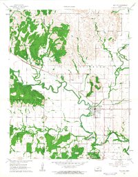 1962 Elk City1963 Print · USGSElk City and the surrounding rural townships are caught in detail during the early sixties, showing the town's original street grid and rail ties. Genealogists and local historians can locate Oak Hill Cemetery, follow the Atchison Topeka and Santa Fe tracks, and trace the winding Elk River.
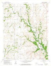
 - 1962 Map of Chautauqua, 1963 Print
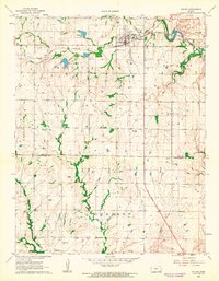
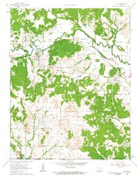
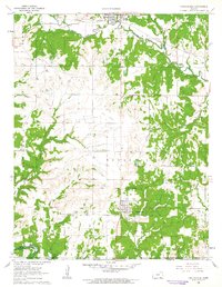 1962 Chautauqua1963 Print · USGSThe Kansas-Oklahoma border region in the early sixties showcases a landscape shaped by petroleum extraction and new reservoirs. Genealogists and historians can locate several family burial grounds like Oak Grove Cem and trace the Old Indian Treaty Boundary.2 unique versions available
 - 1963 Map of Tulsa
 1963 Tulsa1963 Print · USGSThe Oklahoma and Arkansas borderlands are shown here in the early sixties, a time of massive reservoir construction and heavy mining. Genealogists can trace family roots through settlements like Nowata, Pryor, and Jay, or locate historical zinc and lead mines and coal mines.
End of results
Showing maps 1-19 of 19
Top cities of Chautauqua County
- Sedan historical maps
- Cedar Vale historical maps
- Peru historical maps
- Niotaze historical maps
- Chautauqua historical maps
- Elgin historical maps
Frequently asked questions
- What are the different types of historical maps available for Chautauqua County?
- What is the oldest map of Chautauqua County?
- Where can I purchase historical maps of Chautauqua County for my home or office?
- Where can I download high-res historical maps of Chautauqua County?
- Are there historical topographic maps available for Chautauqua County?
- Is there historical aerial imagery available for Chautauqua County?
- Where are historical maps of Chautauqua County sourced from?