1960s Maps of Jewell County, Kansas
Explore 21 historic maps of Jewell County from the 1960s. These maps offer a rare glimpse into what life looked like during the 1960s — showing old roads, neighborhoods, homes, and landmarks that have changed or disappeared over time.
Whether you're researching your family's past, planning a metal detecting trip, or studying how Jewell County's landscape evolved across the 1960s, these high-resolution maps are a powerful tool for exploring the history of this region.
- Focus on a specific era: All maps on this page are from the 1960s, giving you a focused view of this time period.
- See what’s changed: Compare century-old streets, trails, and buildings to today's modern landscape using overlays and satellite layers.
- Research with precision: Use these maps for genealogy, historical research, land use analysis, or educational projects.
- View, download, or print: Maps are fully viewable online in high resolution, and can be downloaded or printed for your own records.
Start exploring Jewell County's history through authentic maps from the 1960s. This is your window into the past.
Jewell County, KS maps
(21)- 1960 Map of Downs North, 1962 Print
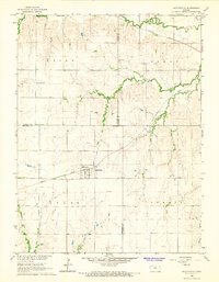
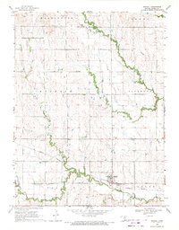
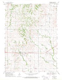
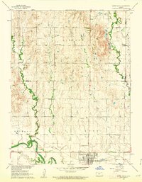 1960 Downs North1962 Print · USGSThe Smith and Osborne County borderlands come to life in the early 1960s at the junction of the Solomon River forks. Researchers can locate vanished rural landmarks like Pleasant Ridge Sch, the settlement of Dispatch, and Rose Valley Ch.2 unique versions available
 - 1962 Map of Jewell SE, 1963 Print
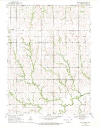
 1962 Jewell SE1963 Print · USGSJewell and Mitchell counties meet along this quiet stretch of Kansas prairie in the early sixties. Researchers can trace the path of the Missouri Pacific railroad or locate family sites near Pleasant Prairie Cem and Plum Creek.
 - 1962 Map of Cawker City, 1963 Print
 1962 Cawker City1963 Print · USGSCawker City thrived as a rail and river hub during the early sixties, anchoring a landscape of small family farms and rural townships. Researchers can trace ancestral roots through several local burial grounds like Prairie Grove Cem and locate the historic Chandler Sch.3 unique versions available
 - 1962 Map of Glen Elder North, 1963 Print
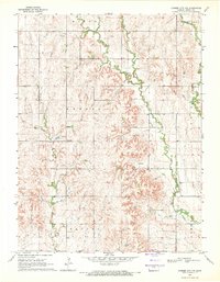
 1962 Glen Elder North1963 Print · USGSJewell and Mitchell counties are captured in the early sixties, centered on the rural hub of Glen Elder and the Athens township. Genealogists and historians can trace the foundations of this farming community through the Athens Sch, Glenwood Cem, and the Missouri Pacific rail corridor.2 unique versions available
 - 1962 Map of Jewell SW, 1963 Print
 1962 Jewell SW1963 Print · USGSThe rural borderlands of Jewell and Mitchell Counties come into focus in the early sixties, showing a landscape of high prairie and winding creek bottoms. Genealogists can locate family landmarks like Mayview Ch, Pleasant Plain Sch, and Star Cem.
 - 1966 Map of Scottsville, 1967 Print
 1966 Scottsville1967 Print · USGSIn the mid-sixties, the prairie landscape around the Mitchell and Jewell County border was a quiet network of railroad sidings and rural townships. Researchers can trace the path of the Missouri Pacific through Scottsville or locate family plots at St Marys Cem and Lutheran Cem.
 - 1968 Map of Burr Oak NW, 1971 Print
 1968 Burr Oak NW1971 Print · USGSJewell County, Kansas and Webster County, Nebraska are captured here in the late sixties, showing the rural homesteads and townships along the state line. Researchers can trace family history through sites like Union Chapel, Graves, and Highland Cem.
 - 1968 Map of Jamestown NW, 1971 Print
 1968 Jamestown NW1971 Print · USGSNorth-Central Kansas is documented here in the late sixties, where the convergence of major rail lines and waterways shaped the rural landscape. Researchers can locate the St Lukes Ch Cem, the Caldwell Cem, and the sprawling Jamestown State Waterfowl Management Area.
 - 1968 Map of Burr Oak, 1971 Print
 1968 Burr Oak1971 Print · USGSJewell County's rolling farmland and rail corridors are frozen in time during the late sixties. Genealogists and historians can locate rural homesteads and trace the Chicago Rock Island and Pacific line between Otego and Burr Oak.
 - 1969 Map of Randall, 1971 Print
 1969 Randall1971 Print · USGSJewell County's agricultural and rail-driven landscape comes into focus in the late sixties, centered on the settlement of Randall. Genealogists and historians can trace old property lines across several townships, finding landmarks like the Wallace Cem and the Missouri Pacific railroad tracks.
 - 1969 Map of Ionia, 1971 Print
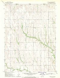
 1969 Ionia1971 Print · USGSIn Jewell County during the late sixties, the township of Ionia remained a focal point for the surrounding farming community. Researchers can locate family landmarks like the McGehee Cem or trace the early development of Jewell County State Park on Ash Creek.
 - 1969 Map of Cawker City NW, 1971 Print
 1969 Cawker City NW1971 Print · USGSJewell County farmland is documented here in the late sixties, showing the rural structure of townships and drainage basins. Genealogists and local historians can locate Dentonia, trace family-named landmarks like Odessa Ch, or find the Mt Carmel Cem near the winding West Limestone Creek.
 - 1969 Map of Mankato, 1971 Print
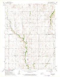
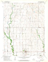
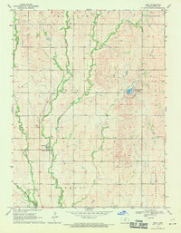
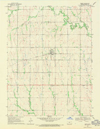
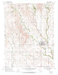
 1969 Mankato1971 Print · USGSJewell County's seat at Mankato is shown at the end of the 1960s, precisely where the Missouri Pacific and Rock Island railroads meet. Genealogists can locate several local burial grounds like Mt Hope Cem and Lutheran Cem or the rural East Union Community Hall.
 - 1969 Map of Montrose, 1971 Print
 1969 Montrose1971 Print · USGSJewell County's agricultural heartland is documented here in the late sixties, centered on the rail-side community of Montrose. Researchers can trace local lineage through Switzers Gap Cem and Delta Cem or follow the path of the Courtland Canal.
 - 1969 Map of North Branch, 1971 Print
 1969 North Branch1971 Print · USGSThe Kansas-Nebraska borderlands in the late sixties are captured here, centered on the farming communities of northern Jewell County. Genealogists and local historians can trace the rural layouts of North Branch, Burr Oak, and Wesley Center alongside several local Quarry sites.
 - 1969 Map of Mankato NW, 1971 Print
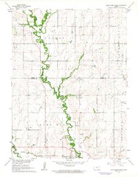
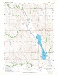
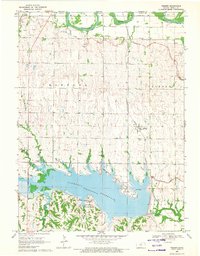
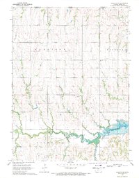 1969 Mankato NW1971 Print · USGSJewell County, Kansas, near the Nebraska border shows a late-sixties landscape transitioning from traditional farming to a reservoir-centered economy. Researchers can trace rural cemetery locations like Cleveland Cem or follow the path of White Rock Creek to the Lovewell Reservoir.
 - 1969 Map of Scandia NW, 1971 Print
 1969 Scandia NW1971 Print · USGSThe Kansas-Nebraska borderlands are shown here in the late sixties, where irrigation canals and river bends define the rural landscape. Researchers can trace the Burlington Northern line through Warwick or find family roots at White Rock Cem and Rose Mound Cent.
 - 1969 Map of Esbon, 1971 Print
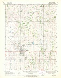
 1969 Esbon1971 Print · USGSJewell County, Kansas, is captured here in the late sixties, centered on the railroad town of Esbon. Genealogists and historians can trace local landmarks like the Westside Community Center and multiple rural burial sites including Prairie Home Cem and Zion Cem.2 unique versions available
 - 1969 Map of Webber, 1971 Print
 1969 Webber1971 Print · USGSThe northern reaches of Jewell County meet the Nebraska border here in the late sixties, where the recently completed Lovewell Reservoir reshaped the valley. Genealogists and local historians can trace the rail corridor of the Atchison Topeka and Santa Fe through Webber and locate rural landmarks like Montana Cem and Valley View Cem.
 - 1969 Map of Jewell, 1971 Print
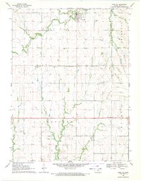
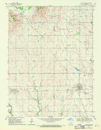
 1969 Jewell1971 Print · USGSJewell County's agricultural and rail-oriented landscape is captured here during the late sixties. Researchers can trace the Missouri Pacific rail corridor and locate family heritage sites like McGehee Cem, Union Cem, and the town of Jewell.
 - 1969 Map of Courtland, 1971 Print
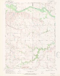
 1969 Courtland1971 Print · USGSJewell and Republic Counties appear in the late sixties as a thriving agricultural and rail hub. Genealogists and local historians can trace family roots through numerous burial grounds like Laurel Hill Cem and Balch Cem, or follow the path of the Courtland Canal.
End of results
Showing maps 1-21 of 21
Top cities of Jewell County
- Mankato historical maps
- Jewell historical maps
- Burr Oak historical maps
- Formoso historical maps
- Esbon historical maps
- Ionia historical maps
See more
Frequently asked questions
- What are the different types of historical maps available for Jewell County?
- What is the oldest map of Jewell County?
- Where can I purchase historical maps of Jewell County for my home or office?
- Where can I download high-res historical maps of Jewell County?
- Are there historical topographic maps available for Jewell County?
- Is there historical aerial imagery available for Jewell County?
- Where are historical maps of Jewell County sourced from?