1970s Maps of McPherson County, Kansas
Explore 4 historic maps of McPherson County from the 1970s. These maps offer a rare glimpse into what life looked like during the 1970s — showing old roads, neighborhoods, homes, and landmarks that have changed or disappeared over time.
Whether you're researching your family's past, planning a metal detecting trip, or studying how McPherson County's landscape evolved across the 1970s, these high-resolution maps are a powerful tool for exploring the history of this region.
- Focus on a specific era: All maps on this page are from the 1970s, giving you a focused view of this time period.
- See what’s changed: Compare century-old streets, trails, and buildings to today's modern landscape using overlays and satellite layers.
- Research with precision: Use these maps for genealogy, historical research, land use analysis, or educational projects.
- View, download, or print: Maps are fully viewable online in high resolution, and can be downloaded or printed for your own records.
Start exploring McPherson County's history through authentic maps from the 1970s. This is your window into the past.
McPherson County, KS maps
(4)- 1971 Map of Lehigh, 1972 Print
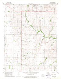 1971 Lehigh1972 Print · USGSMarion County's Mennonite farming heartland is captured here in the early seventies, centered on the rail-side community of Lehigh. Researchers can trace local lineage through several historic sites, including the Alexanderwohl Ch and Springfield Cem.2 unique versions available
 - 1971 Map of Waldeck, 1972 Print
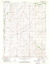 1971 Waldeck1972 Print · USGSMarion County rail and river life is captured here in the early seventies, centered on the small settlements of Lehigh and Waldeck. Researchers can trace old family roots at Mennonite Cem and follow the paths of the Atchison Topeka and Santa Fe railroad.2 unique versions available
 - 1971 Map of Canton SW, 1972 Print
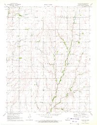 1971 Canton SW1972 Print · USGSMcPherson County agricultural life and early energy production are captured here in the early 1970s. Genealogists can locate rural landmarks like Sunny Hill Sch, Immanuel Ch, and Meridian Cem along the banks of Spring Valley Creek.2 unique versions available
 - 1971 Map of Canton, 1972 Print
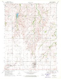 1971 Canton1972 Print · USGSMcPherson County's prairie landscape is captured in the early seventies as a center for energy production and conservation. Genealogists and historians can trace the paths of two major railroads and locate sites like the United Center Sch, Jones Cem, and the Maxwell Game Refuge.2 unique versions available
End of results
Showing maps 1-4 of 4
Top cities of McPherson County
- McPherson historical maps
- Lindsborg historical maps
- Moundridge historical maps
- Inman historical maps
- Canton historical maps
- Galva historical maps
See more
Frequently asked questions
- What are the different types of historical maps available for McPherson County?
- What is the oldest map of McPherson County?
- Where can I purchase historical maps of McPherson County for my home or office?
- Where can I download high-res historical maps of McPherson County?
- Are there historical topographic maps available for McPherson County?
- Is there historical aerial imagery available for McPherson County?
- Where are historical maps of McPherson County sourced from?