Old Maps of Morton County, Kansas for Genealogy
Trace your family roots with 166 historic maps of Morton County. These high-res maps reveal old neighborhoods, homesites, landmarks, and streets — helping you uncover where your ancestors lived and how the area evolved over time.
- Explore historic neighborhoods: Identify where your relatives may have lived in the 1800s or 1900s.
- Compare maps over time: Trace the changes in streets, buildings, and landmarks for multi-generational research.
- Perfect for genealogy & ancestry research: Used by family historians and researchers to map out lineage and migration.
These maps are an incredible resource for exploring your personal connection to Morton County's past.
Morton County, KS maps
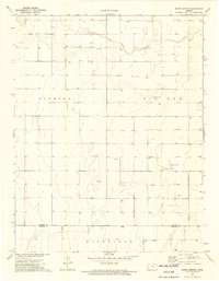
(166)- 1892 Map of Vilas
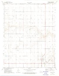
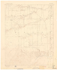 1892 Vilas1892 Print · USGSSoutheast Colorado and the Kansas borderland are shown here in the early 1890s, when ranching and the cattle trade dominated the high plains. Genealogists and historians can trace the Texas Trail and early settlements like Boston, Vilas, and Mathews Ranch.5 unique versions available
 - 1954 Map of Perryton, 1966 Print
 1954 Perryton1966 Print · USGSThe High Plains of the Texas and Oklahoma panhandles are shown during a period of steady growth in the mid-1950s. Genealogists and researchers can trace rail history and local landmarks like Panhandle A & M College, Spurlock Chapel, and the isolated Lord Station.3 unique versions available
 - 1954 Map of Dalhart, 1967 Print
 1954 Dalhart1967 Print · USGSThe High Plains at the junction of four states come alive in the mid-fifties, showing a landscape of rail-hub towns and cattle country. Trace the Old Santa Fe Trail or locate mid-century industrial sites like the Dry ice plant and Carbon Dioxide Works.2 unique versions available
 - 1955 Map of La Junta, 1966 Print
 1955 La Junta1966 Print · USGSSoutheastern Colorado during the mid-fifties is captured here as a sprawling network of ranching outposts and rail sidings. Researchers can locate vanished landmarks like the Sunderland School, trace the isolated Lycan Post Office, or find the Bomb target (abandoned) on the western plains.3 unique versions available
 - 1955 Map of Dodge City, 1968 Print
 1955 Dodge City1968 Print · USGSSouthwest Kansas in the mid-fifties reveals an expansive landscape of cattle towns, early gas fields, and prairie outposts. Researchers can trace rural school districts like Moundview and Good Luck or locate the Kansas State Game Farm near Lakin.3 unique versions available
 - 1958 Map of Perryton
 1958 Perryton1958 Print · USGSThe Oklahoma Panhandle and Texas borderlands come alive in this mid-century survey, showing the vital rail-and-ranch economy of the High Plains. Researchers can trace historic stops along the Chicago Rock Island and Pacific and locate rural landmarks like Bethel Church and Spurlock Chapel.
 - 1958 Map of La Junta
 1958 La Junta1958 Print · USGSSoutheast Colorado and the Kansas borderlands appear in the late fifties as a landscape of isolated ranching outposts and vital rail junctions. Researchers can trace the lineage of vanished post offices and rural school sites like the Lycan Post Office and Sunderland School.2 unique versions available
 - 1958 Map of Dodge City
 1958 Dodge City1958 Print · USGSSouthwest Kansas in the late fifties shows a landscape of river-valley agriculture and burgeoning energy infrastructure. Genealogists can trace rural life through numerous landmarks like Fairview Cemetery, the Goodwell School, and Concord Church.
 - 1958 Map of Dalhart
 1958 Dalhart1958 Print · USGSThe High Plains of the tri-state border region come alive in this mid-century survey of the ranching and rail territory around the Texas Panhandle. Genealogists and historians can trace the paths of the Atchison Topeka & Santa Fe Ry, military outposts like Dalhart Air Force No 1, and early settlements such as Pasamonte and Texline.2 unique versions available
 - 1959 Map of Dodge City
 1959 Dodge City1959 Print · USGSSouthwest Kansas in the mid-fifties is captured at its agricultural height, centered on the vital rail and river hubs of Dodge City and Garden City. Genealogists and local historians can trace rural school districts like Shockey School and Hickok School or locate the Fairview Cemetery.
 - 1962 Map of Dalhart
 1962 Dalhart1962 Print · USGSThe High Plains and volcanic peaks of the tri-state area are shown in detail during the early sixties. Genealogists and historians can trace the rail corridors of the Fort Worth and Denver and find industrial sites like the Cactus Ordnance Works or the Beaver Meade & Englewood Grain Elevator.
 - 1968 Map of La Junta
 1968 La Junta1968 Print · USGSSoutheastern Colorado and the high plains appear in remarkable detail during the late 1960s, showing the intersection of irrigation, ranching, and rail. Genealogists can trace family footprints at the Lycan Post Office, Konantz Cem, and across numerous named cattle ranches.
 - 1971 Map of Sturgis, 1973 Print
 1971 Sturgis1973 Print · USGSThe Oklahoma Panhandle in the early seventies centers on the rail-side community of Sturgis and the surrounding energy fields. Local researchers can trace the Atchison Topeka and Santa Fe railroad corridor past Goff and the local Roadside Park.
 - 1973 Map of Richfield NW, 1974 Print
 1973 Richfield NW1974 Print · USGSWestern Kansas at the start of the 1970s shows a landscape defined by rail lines and emerging energy development. Researchers can trace the path of the Atchison Topeka and Santa Fe and locate numerous Gas Well sites near Sand Arroyo Creek.
 - 1973 Map of Shore Airport SW, 1975 Print
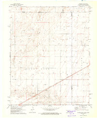
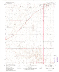
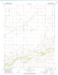
 1973 Shore Airport SW1975 Print · USGSMorton County in the early seventies shows a landscape where historic transit and modern energy meet. Researchers can trace the Old Santa Fe Trail near the Cimarron River or locate family records at Richfield Cem.
 - 1973 Map of Shore Airport, 1975 Print
 1973 Shore Airport1975 Print · USGSThe high plains of Stanton County are documented here in the early seventies, as energy development transformed the rural landscape. Genealogists and researchers can trace local land use through numerous Gas Wells, the site of Shore Airport, and the path of Sand Arroyo Creek.
 - 1973 Map of Elkhart South, 1975 Print
 1973 Elkhart South1975 Print · USGSThe Oklahoma-Kansas border comes to life in the early seventies, centered on the energy-rich panhandle landscape and the town of Elkhart. Researchers can trace the Atchison Topeka and Santa Fe rail line past Libbey or locate local landmarks like the Drive-in Theater.
 - 1973 Map of Rolla NW, 1975 Print
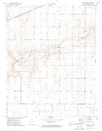
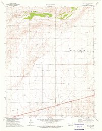
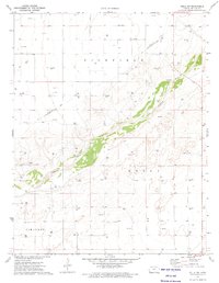 1973 Rolla NW1975 Print · USGSThe high plains of Morton County are shown in the early seventies as a landscape of energy production and historic transit. Researchers can trace the path of the Old Santa Fe Trail and locate dozens of Gas Wells along the Cimarron River.
 - 1973 Map of Richfield NE, 1975 Print
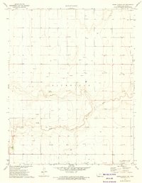
 1973 Richfield NE1975 Print · USGSThe High Plains of Southwest Kansas in the early 1970s reveal a landscape of remote farmsteads and energy development. Genealogists and historians can trace the area's growth through the tiny settlement of Cleaves and the Johns Landing Field airstrip.
 - 1973 Map of Elkhart NE, 1975 Print
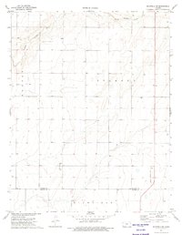
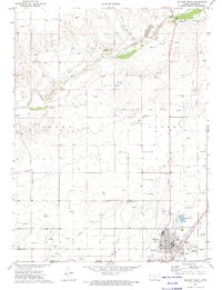
 1973 Elkhart NE1975 Print · USGSMorton County in the early seventies reveals a landscape defined by historic pioneer routes and modern energy production. Researchers can trace the Old Santa Fe Trail alongside the Cimarron River or locate numerous Gas Wells across the Richfield township.
 - 1973 Map of Rolla NE, 1975 Print
 1973 Rolla NE1975 Print · USGSThe High Plains of the Kansas-Oklahoma border region are captured here in the early seventies, showing a landscape defined by energy and rail. Genealogists and historians can trace the Atchison Topeka and Santa Fe line and the Cimarron River valley.
 - 1973 Map of Elkhart North, 1975 Print
 1973 Elkhart North1975 Print · USGSThe High Plains of the Kansas-Oklahoma border are captured here in the early seventies, centered on the railroad town of Elkhart. Genealogists and historians can trace local landmarks like the Cemetery, the A T & S F rail line, and the landmark Point of Rocks along the Cimarron River.
 - 1973 Map of Richfield SW, 1975 Print
 1973 Richfield SW1975 Print · USGSMorton County in the early seventies shows a landscape defined by the expansive High Plains and a growing energy sector. Genealogists and historians can trace the early footprint of the Westola area and locate numerous Gas Well sites scattered across the prairie.
 - 1973 Map of Richfield, 1975 Print
 1973 Richfield1975 Print · USGSRichfield and the surrounding High Plains are captured here in the early seventies during a period of significant energy development. Genealogists and researchers can trace the local landscape through features like Bradles, the North Fork Cimarron River, and numerous Gas Wells.
 - 1973 Map of Elkhart NW, 1975 Print
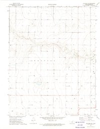
 1973 Elkhart NW1975 Print · USGSMorton County in the early 1970s shows a landscape of river valleys and active energy extraction. Researchers can trace the path of the North Fork Cimarron River or locate numerous Gas Wells and a Gravel Pit across Westola and Taloga.
Showing maps 1-25 of 166
Top cities of Morton County
Frequently asked questions
- What are the different types of historical maps available for Morton County?
- What is the oldest map of Morton County?
- Where can I purchase historical maps of Morton County for my home or office?
- Where can I download high-res historical maps of Morton County?
- Are there historical topographic maps available for Morton County?
- Is there historical aerial imagery available for Morton County?
- Where are historical maps of Morton County sourced from?