1960s Maps of Osborne County, Kansas
Explore 7 historic maps of Osborne County from the 1960s. These maps offer a rare glimpse into what life looked like during the 1960s — showing old roads, neighborhoods, homes, and landmarks that have changed or disappeared over time.
Whether you're researching your family's past, planning a metal detecting trip, or studying how Osborne County's landscape evolved across the 1960s, these high-resolution maps are a powerful tool for exploring the history of this region.
- Focus on a specific era: All maps on this page are from the 1960s, giving you a focused view of this time period.
- See what’s changed: Compare century-old streets, trails, and buildings to today's modern landscape using overlays and satellite layers.
- Research with precision: Use these maps for genealogy, historical research, land use analysis, or educational projects.
- View, download, or print: Maps are fully viewable online in high resolution, and can be downloaded or printed for your own records.
Start exploring Osborne County's history through authentic maps from the 1960s. This is your window into the past.
Osborne County, KS maps
(7)- 1960 Map of Downs North, 1962 Print
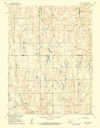
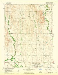 1960 Downs North1962 Print · USGSThe Smith and Osborne County borderlands come to life in the early 1960s at the junction of the Solomon River forks. Researchers can locate vanished rural landmarks like Pleasant Ridge Sch, the settlement of Dispatch, and Rose Valley Ch.2 unique versions available
 - 1961 Map of Kirwin SE, 1962 Print
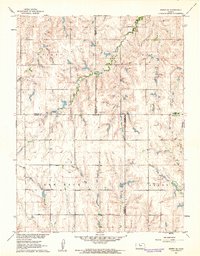 1961 Kirwin SE1962 Print · USGSThe rural crossroads of Rooks, Phillips, Smith, and Osborne counties are captured here in the early sixties. Genealogists can locate family sites and rural landmarks like Bohemian Cem, Spring Branch Cem, and Ash Rock Sch 2.
 - 1961 Map of Portis, 1962 Print
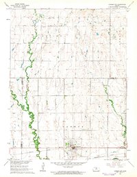
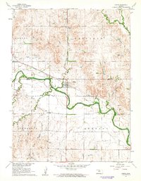 1961 Portis1962 Print · USGSThe Osborne County plains in the early sixties reveal a landscape of river-valley farming and rail transport. Genealogists can trace family landmarks like Fairview Cem and Garrett Cem near the North Fork Solomon River.
 - 1961 Map of Harlan, 1962 Print
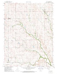
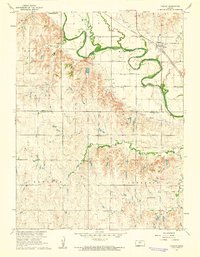 1961 Harlan1962 Print · USGSNorth central Kansas farmland is documented here in the early 1960s, showing the intricate water management along the North Fork Solomon River. Genealogists and local historians can locate the Harlan townsite, Butler Cem, and rural congregations like Mayflower Ch.
 - 1961 Map of Gaylord SW, 1962 Print
 1961 Gaylord SW1962 Print · USGSNorth-central Kansas in the early 1960s was a landscape of township divisions and rural stream valleys. Genealogists and local historians can trace family locations near Leasburg Cem, Grant Cem, and the waters of Glen Creek.
 - 1962 Map of Cawker City, 1963 Print
 1962 Cawker City1963 Print · USGSCawker City thrived as a rail and river hub during the early sixties, anchoring a landscape of small family farms and rural townships. Researchers can trace ancestral roots through several local burial grounds like Prairie Grove Cem and locate the historic Chandler Sch.3 unique versions available
 - 1967 Map of Hunter, 1969 Print
 1967 Hunter1969 Print · USGSThe rural plains of Mitchell and Lincoln counties are captured here in the late sixties, centered on the railroad town of Hunter. Genealogists and historians can trace local family landmarks such as Greenwood Union Cem, Spillman Cem, and the winding Bacon Creek.
End of results
Showing maps 1-7 of 7
Top cities of Osborne County
- Osborne historical maps
- Downs historical maps
- Natoma historical maps
- Portis historical maps
- Alton historical maps
- Corinth historical maps
See more
Frequently asked questions
- What are the different types of historical maps available for Osborne County?
- What is the oldest map of Osborne County?
- Where can I purchase historical maps of Osborne County for my home or office?
- Where can I download high-res historical maps of Osborne County?
- Are there historical topographic maps available for Osborne County?
- Is there historical aerial imagery available for Osborne County?
- Where are historical maps of Osborne County sourced from?