1950s Maps of Osborne County, Kansas
Explore 8 historic maps of Osborne County from the 1950s. These maps offer a rare glimpse into what life looked like during the 1950s — showing old roads, neighborhoods, homes, and landmarks that have changed or disappeared over time.
Whether you're researching your family's past, planning a metal detecting trip, or studying how Osborne County's landscape evolved across the 1950s, these high-resolution maps are a powerful tool for exploring the history of this region.
- Focus on a specific era: All maps on this page are from the 1950s, giving you a focused view of this time period.
- See what’s changed: Compare century-old streets, trails, and buildings to today's modern landscape using overlays and satellite layers.
- Research with precision: Use these maps for genealogy, historical research, land use analysis, or educational projects.
- View, download, or print: Maps are fully viewable online in high resolution, and can be downloaded or printed for your own records.
Start exploring Osborne County's history through authentic maps from the 1950s. This is your window into the past.
Osborne County, KS maps
(8)- 1953 Map of Downs South
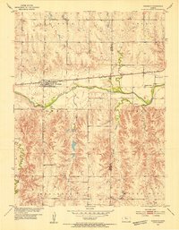
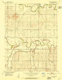 1953 Downs South1953 Print · USGSOsborne County farming and transit are captured here in the early fifties, where the river and rail lines converge. Genealogists can locate family landmarks such as Iowa Cem and Cottonwood Sch along the South Fork Solomon River.3 unique versions available
 - 1953 Map of Waconda Springs, 1954 Print
 1953 Waconda Springs1954 Print · USGSMitchell County in the early fifties shows the Solomon River valley just before the landscape was transformed by reservoir construction. Genealogists and researchers can locate Waconda Springs, the St Peter and Paul Cem, and the rural Town Hall at the heart of Carr Creek.4 unique versions available
 - 1953 Map of Bloomington, 1954 Print
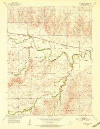 1953 Bloomington1954 Print · USGSOsborne County in the early 1950s is defined by its rural schoolhouses and the winding South Fork Solomon River. Genealogists can trace family landmarks near Bloomington, including Mayview Sch and the United Brethren Ch.3 unique versions available
 - 1953 Map of Osborne, 1954 Print
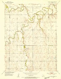
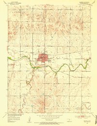 1953 Osborne1954 Print · USGSOsborne was a vital rail and river crossing in north-central Kansas during the early fifties. Local historians can trace family roots through sites like Bethany Center Cem and Mt Hope Sch or follow the lines of the Missouri Pacific railroad.3 unique versions available
 - 1953 Map of Woodston, 1954 Print
 1953 Woodston1954 Print · USGSThe town of Woodston and its surrounding townships are shown here in the early fifties, caught between the river and the rail line. Researchers can trace the mid-century footprint of local education and community at High Sch, Pleasant Valley Sch, and the Pleasant Valley Cem.2 unique versions available
 - 1953 Map of Alton, 1954 Print
 1953 Alton1954 Print · USGSOsborne County farm country is mapped here in the early fifties, centered on the riverfront town of Alton. Genealogists can trace early rural life through detailed landmarks like Mount Ayr Sch, Sumner Cem, and the Missouri Pacific rail line.3 unique versions available
 - 1955 Map of Beloit, 1971 Print
 1955 Beloit1971 Print · USGSNorth Central Kansas in the mid-fifties shows a landscape of river-valley agriculture and expanding water infrastructure. Genealogists can trace the rail lines of the Union Pacific through towns like Nicodemus, Cawker City, and the State Sanatorium.3 unique versions available
 - 1959 Map of Beloit
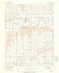
 1959 Beloit1959 Print · USGSNorth Central Kansas at mid-century reveals a landscape shaped by river valleys and the expansion of massive water reservoirs. Genealogists and historians can trace the rail-town connections of Beloit and Norton or locate the site of the new Webster Dam.3 unique versions available
End of results
Showing maps 1-8 of 8
Top cities of Osborne County
- Osborne historical maps
- Downs historical maps
- Natoma historical maps
- Portis historical maps
- Alton historical maps
- Corinth historical maps
See more
Frequently asked questions
- What are the different types of historical maps available for Osborne County?
- What is the oldest map of Osborne County?
- Where can I purchase historical maps of Osborne County for my home or office?
- Where can I download high-res historical maps of Osborne County?
- Are there historical topographic maps available for Osborne County?
- Is there historical aerial imagery available for Osborne County?
- Where are historical maps of Osborne County sourced from?