1970s Maps of Osborne County, Kansas
Explore 11 historic maps of Osborne County from the 1970s. These maps offer a rare glimpse into what life looked like during the 1970s — showing old roads, neighborhoods, homes, and landmarks that have changed or disappeared over time.
Whether you're researching your family's past, planning a metal detecting trip, or studying how Osborne County's landscape evolved across the 1970s, these high-resolution maps are a powerful tool for exploring the history of this region.
- Focus on a specific era: All maps on this page are from the 1970s, giving you a focused view of this time period.
- See what’s changed: Compare century-old streets, trails, and buildings to today's modern landscape using overlays and satellite layers.
- Research with precision: Use these maps for genealogy, historical research, land use analysis, or educational projects.
- View, download, or print: Maps are fully viewable online in high resolution, and can be downloaded or printed for your own records.
Start exploring Osborne County's history through authentic maps from the 1970s. This is your window into the past.
Osborne County, KS maps
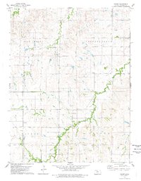
(11)- 1978 Map of Natoma, 1979 Print
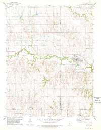 1978 Natoma1979 Print · USGSThe Kansas plains of the late seventies come alive on this sheet centered on the rail-side community of Natoma. Researchers can trace the legacy of local industry and genealogy through the Oil Field and landmarks like Conger Cem.
 - 1978 Map of Osborne SW, 1979 Print
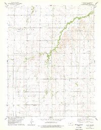
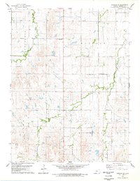 1978 Osborne SW1979 Print · USGSOsborne County farm country is mapped here in the late seventies, showing the township lines and creek beds of the Kansas prairie. Genealogists can locate Zimmerman Cem and trace the paths of Covert Creek and Twin Creek through the land.
 - 1978 Map of Paradise NW, 1979 Print
 1978 Paradise NW1979 Print · USGSOsborne and Russell County lands appear in the late 1970s as a quiet expanse of prairie and energy production. Researchers can trace the path of the Union Pacific railroad or locate local landmarks like I X L Cem and the summit of Round Mound.
 - 1978 Map of Tipton, 1979 Print
 1978 Tipton1979 Print · USGSThe northern Kansas prairie around Tipton is captured here in the late seventies as the rail-and-ranching economy remained firmly in place. Genealogists can locate family plots at St Boniface Cem and Union Cem or trace the Atchison Topeka and Santa Fe line.
 - 1978 Map of Alton SW, 1979 Print
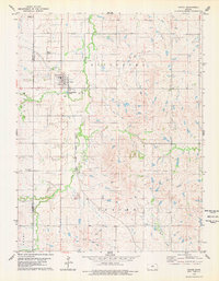
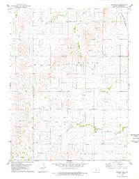
 1978 Alton SW1979 Print · USGSOsborne County, Kansas, in the late 1970s shows a landscape of upland ridges and winding creek beds. Researchers can locate community anchors like Round Mound Cem, Enterprise Ch, and the Kill Creek No 2 school site.
 - 1978 Map of Osborne SE, 1979 Print
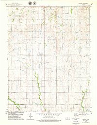
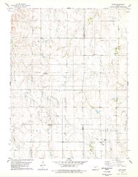
 1978 Osborne SE1979 Print · USGSOsborne County in the late seventies is captured here as a landscape of rural townships and winding creek beds. Genealogists and historians can trace family land across Bloom and Delhi or follow the Atchison Topeka and Santa Fe rail line.
 - 1978 Map of Vincent, 1979 Print
 1978 Vincent1979 Print · USGSOsborne and Russell counties in the late 1970s reveal a landscape of high-plains agriculture and small rural centers. Researchers can trace family history through the Potterville Cemetery and Cheyenne Church or locate landmarks like Cheyenne Gap.
 - 1978 Map of Meades Ranch, 1979 Print
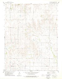
 1978 Meades Ranch1979 Print · USGSOsborne County in the late seventies is captured here at a critical moment for American surveying history. Genealogists and researchers can locate the Meades Ranch geodetic base point and the rural Delhi Cem along the East Fork Wolf Creek.
 - 1978 Map of Covert, 1979 Print
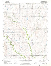
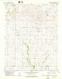
 1978 Covert1979 Print · USGSOsborne County farming and oil exploration define this late-1970s landscape near the settlement of Covert. Genealogists and historians can trace family roots at Bristow Cem, Covert Cem, and Cedar Bluff Cem along the winding Kill Creek.
 - 1978 Map of Paradise NE, 1979 Print
 1978 Paradise NE1979 Print · USGSThe rural border of Osborne and Russell Counties comes alive in the late seventies as a land of small townships and prairie drainages. Genealogists can locate family landmarks like Cedar Bluff Cem and Grand Center Cem or trace the Union Pacific rail line.
 - 1978 Map of Laton, 1979 Print
 1978 Laton1979 Print · USGSRooks and Osborne Counties appear here in the late 1970s, showcasing the rural character of the Kansas prairie. Genealogists and historians can trace family roots through several landmarks, including Laton, the Pleasant Plain Church, and Chalk Mound Cemetery.
End of results
Showing maps 1-11 of 11
Top cities of Osborne County
- Osborne historical maps
- Downs historical maps
- Natoma historical maps
- Portis historical maps
- Alton historical maps
- Corinth historical maps
See more
Frequently asked questions
- What are the different types of historical maps available for Osborne County?
- What is the oldest map of Osborne County?
- Where can I purchase historical maps of Osborne County for my home or office?
- Where can I download high-res historical maps of Osborne County?
- Are there historical topographic maps available for Osborne County?
- Is there historical aerial imagery available for Osborne County?
- Where are historical maps of Osborne County sourced from?