1970s Maps of Reno County, Kansas
Explore 11 historic maps of Reno County from the 1970s. These maps offer a rare glimpse into what life looked like during the 1970s — showing old roads, neighborhoods, homes, and landmarks that have changed or disappeared over time.
Whether you're researching your family's past, planning a metal detecting trip, or studying how Reno County's landscape evolved across the 1970s, these high-resolution maps are a powerful tool for exploring the history of this region.
- Focus on a specific era: All maps on this page are from the 1970s, giving you a focused view of this time period.
- See what’s changed: Compare century-old streets, trails, and buildings to today's modern landscape using overlays and satellite layers.
- Research with precision: Use these maps for genealogy, historical research, land use analysis, or educational projects.
- View, download, or print: Maps are fully viewable online in high resolution, and can be downloaded or printed for your own records.
Start exploring Reno County's history through authentic maps from the 1970s. This is your window into the past.
Reno County, KS maps
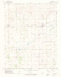
(11)- 1970 Map of Nickerson, 1972 Print
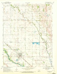 1970 Nickerson1972 Print · USGSNickerson sits at a vital rail and river junction in central Kansas during the early seventies. Genealogists and local historians can trace family locations near Wildmead Cem or explore the mid-century industrial footprint of the Wherry Oil Field and the Fish Farm.
 - 1971 Map of Little Salt Marsh, 1972 Print
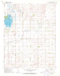 1971 Little Salt Marsh1972 Print · USGSReno and Stafford Counties are captured in the early seventies, a time when the wetland conservation of the Quivira National Wildlife Refuge met the local oil economy. Genealogists and historians can trace family ties at the Hayes Cem or locate the old Fairview Ch near Peace Creek.
 - 1971 Map of Alden SE, 1972 Print
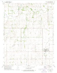
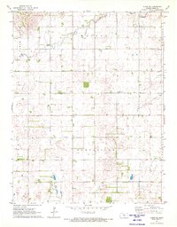 1971 Alden SE1972 Print · USGSReno County's agricultural and energy landscape is captured here in the early seventies, centered on the settlement of Huntsville. Genealogists and local historians can locate the Huntsville Cem, Pleasant View Cem, and numerous Oil Wells across the prairie.2 unique versions available
 - 1971 Map of Turon, 1974 Print
 1971 Turon1974 Print · USGSTuron thrived as a dual-railroad junction in the early seventies, where the Chicago Rock Island and Missouri Pacific lines intersected. Researchers can locate family plots at Neola Cem and Pleasant Valley Cem or trace the historical Old Indian Treaty Boundary.
 - 1971 Map of Sylvia, 1974 Print
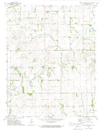
 1971 Sylvia1974 Print · USGSReno County's agricultural and energy landscape comes into focus during the early 1970s, centered on the railroad town of Sylvia. Genealogists and local historians can trace family locations near Zenith, Glendale Cem, and the Fish Hatchery along the river.
 - 1971 Map of Pretty Prairie, 1974 Print
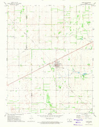
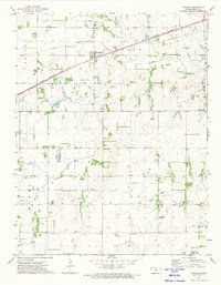
 1971 Pretty Prairie1974 Print · USGSPretty Prairie and the surrounding Reno County townships are captured here in the early 1970s. Trace local genealogy and land use through the Township Cem, the Atchison Topeka and Santa Fe rail line, and the Old Indian Treaty Boundary.
 - 1971 Map of Pretty Prairie SW, 1974 Print
 1971 Pretty Prairie SW1974 Print · USGSReno County in the early 1970s shows a landscape of traditional Kansas townships intersected by a historic Old Indian Treaty Boundary. Genealogists and historians can trace local landmarks like Sego Cem, the Townhall, and the C R I & P rail line.
 - 1971 Map of Langdon, 1974 Print
 1971 Langdon1974 Print · USGSReno County in the early seventies shows a landscape where prairie agriculture meets industrial energy development. Genealogists and historians can trace the Old Indian Treaty Boundary or locate family sites near Langdon Cem and Lerado.
 - 1971 Map of Arlington, 1974 Print
 1971 Arlington1974 Print · USGSReno County's agricultural heartland is documented here in the early seventies, centered on the river-and-rail junctions of the Kansas plains. Researchers can trace family roots through the Abbyville Cem, locate the Amish Ch, or follow the path of the North Fork Ninnescah River.
 - 1971 Map of Plevna, 1974 Print
 1971 Plevna1974 Print · USGSReno County's agricultural heartland was well-established by the 1970s, centered on the rail-side community of Plevna. Researchers can trace old family burial grounds at Hazen Cem and Bainum Cem or locate local gathering spots like the Clark Community Club.
 - 1972 Map of Partridge, 1974 Print
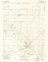
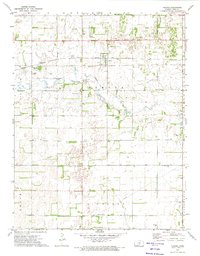
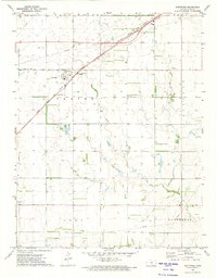 1972 Partridge1974 Print · USGSPartridge in the early 1970s was a critical rail junction where the Santa Fe and Rock Island lines met. Researchers can trace rural landmarks like Eureka Sch, Center Cem, and the Experimental Farm.
End of results
Showing maps 1-11 of 11
Top cities of Reno County
- Hutchinson historical maps
- South Hutchinson historical maps
- Medora historical maps
- Buhler historical maps
- Haven historical maps
- Nickerson historical maps
See more
Frequently asked questions
- What are the different types of historical maps available for Reno County?
- What is the oldest map of Reno County?
- Where can I purchase historical maps of Reno County for my home or office?
- Where can I download high-res historical maps of Reno County?
- Are there historical topographic maps available for Reno County?
- Is there historical aerial imagery available for Reno County?
- Where are historical maps of Reno County sourced from?