1980s Maps of Russell County, Kansas
Explore 4 historic maps of Russell County from the 1980s. These maps offer a rare glimpse into what life looked like during the 1980s — showing old roads, neighborhoods, homes, and landmarks that have changed or disappeared over time.
Whether you're researching your family's past, planning a metal detecting trip, or studying how Russell County's landscape evolved across the 1980s, these high-resolution maps are a powerful tool for exploring the history of this region.
- Focus on a specific era: All maps on this page are from the 1980s, giving you a focused view of this time period.
- See what’s changed: Compare century-old streets, trails, and buildings to today's modern landscape using overlays and satellite layers.
- Research with precision: Use these maps for genealogy, historical research, land use analysis, or educational projects.
- View, download, or print: Maps are fully viewable online in high resolution, and can be downloaded or printed for your own records.
Start exploring Russell County's history through authentic maps from the 1980s. This is your window into the past.
Russell County, KS maps
(4)- 1985 Map of Plainville
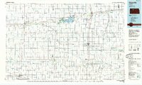 1985 Plainville1985 Print · USGSNorthwestern Kansas in the mid-eighties reveals a landscape shaped by the Solomon River and the expansion of energy production. Researchers can trace the Union Pacific rail line and locate key sites like the historic settlement of Nicodemus, Webster Reservoir, and numerous oil fields.2 unique versions available
 - 1985 Map of Beloit
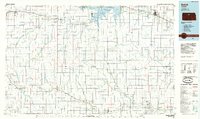 1985 Beloit1985 Print · USGSNorth Central Kansas in the mid-eighties shows a landscape shaped by the Solomon and Saline rivers and the massive Waconda Lake. Researchers can trace the routes of the Missouri Pacific RR and locate rural landmarks like the State Girls School and Denmark.2 unique versions available
 - 1985 Map of Russell
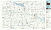 1985 Russell1985 Print · USGSCentral Kansas in the mid-eighties shows a landscape defined by the energy industry and massive water projects. Genealogists and researchers can trace the rural road networks connecting Russell and Ellsworth to smaller locales like Dubuque and Black Wolf.2 unique versions available
 - 1985 Map of Hays
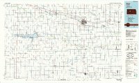 1985 Hays1985 Print · USGSCentral Kansas in the mid-eighties shows a landscape of river-valley farming and emerging energy production. Trace the route of the Butterfield Overland Despatch Trail or locate family roots in Hays, Liebenthal, or Schoenchen.2 unique versions available
End of results
Showing maps 1-4 of 4
Top cities of Russell County
- Russell historical maps
- Lucas historical maps
- Gorham historical maps
- Dorrance historical maps
- Luray historical maps
- Bunker Hill historical maps
See more
Frequently asked questions
- What are the different types of historical maps available for Russell County?
- What is the oldest map of Russell County?
- Where can I purchase historical maps of Russell County for my home or office?
- Where can I download high-res historical maps of Russell County?
- Are there historical topographic maps available for Russell County?
- Is there historical aerial imagery available for Russell County?
- Where are historical maps of Russell County sourced from?