Old Maps of Russell County, Kansas for Genealogy
Trace your family roots with 195 historic maps of Russell County. These high-res maps reveal old neighborhoods, homesites, landmarks, and streets — helping you uncover where your ancestors lived and how the area evolved over time.
- Explore historic neighborhoods: Identify where your relatives may have lived in the 1800s or 1900s.
- Compare maps over time: Trace the changes in streets, buildings, and landmarks for multi-generational research.
- Perfect for genealogy & ancestry research: Used by family historians and researchers to map out lineage and migration.
These maps are an incredible resource for exploring your personal connection to Russell County's past.
Russell County, KS maps
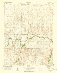
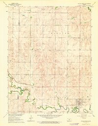
(195)- 1894 Map of Ellsworth
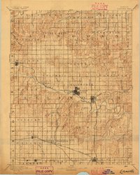 1894 Ellsworth1894 Print · USGSCentral Kansas was undergoing a period of rapid railway expansion in the late nineteenth century, transforming the prairie into a network of grid-organized townships. Genealogists and historians can trace early town sites and rail junctions like Ellsworth, Holyrood, and the path of the Union Pacific Railway.4 unique versions available
 - 1894 Map of Beloit
 1894 Beloit1894 Print · USGSMitchell and Lincoln counties come alive in the 1890s as the railroad and river systems began to shape these Kansas prairie towns. Genealogists and researchers can trace early homesteads and rail-stop settlements like Denmark, Tipton, and the Rocky Hill Mill.3 unique versions available
 - 1896 Map of Osborne
 1896 Osborne1896 Print · USGSNorth Central Kansas in the late nineteenth century was a landscape of budding railroad towns and river-fed townships. Researchers can trace the early layout of Osborne and Luray, or locate vanished rural hubs like Corinth, Bristow, and the Meade Ranch.4 unique versions available
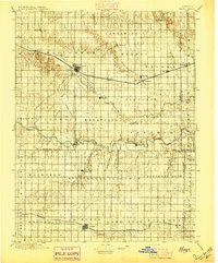
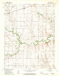
 - 1896 Map of Russell
 1896 Russell1896 Print · USGSCentral Kansas at the end of the nineteenth century reveals a landscape shaped by the Union Pacific and Missouri Pacific railroads. Genealogists can trace early homesteads near Maherville P.O., Dubuque, and the marshy Cheyenne Bottoms.4 unique versions available
 - 1896 Map of Hays
 1896 Hays1896 Print · USGSThe High Plains of central Kansas thrive in the 1890s as twin railroad corridors fuel the growth of new townships and farming communities. Genealogists can trace family roots through early settlements like Catharine, Munjor, and Liebenthal or locate family homesteads along the Union Pacific R. R. and Smoky Hill River.5 unique versions available
 - 1896 Map of Plainville
 1896 Plainville1896 Print · USGSThe Rooks County high plains are seen here in the 1890s as the rail networks expanded across the Solomon and Saline river valleys. Genealogists can trace family roots in early settlements like Plainville, Stockton, and the vanished site of Turkville.3 unique versions available
 - 1955 Map of Great Bend, 1966 Print
 1955 Great Bend1966 Print · USGSCentral Kansas during the mid-sixties transition reveals a landscape defined by new reservoirs and enduring rail corridors. Researchers can trace the development of towns like Hays and Great Bend or locate natural landmarks such as Round Mound and the wetlands of the Quivira National Wildlife Refuge.3 unique versions available
 - 1955 Map of Beloit, 1971 Print
 1955 Beloit1971 Print · USGSNorth Central Kansas in the mid-fifties shows a landscape of river-valley agriculture and expanding water infrastructure. Genealogists can trace the rail lines of the Union Pacific through towns like Nicodemus, Cawker City, and the State Sanatorium.3 unique versions available
 - 1956 Map of Wilson, 1958 Print
 1956 Wilson1958 Print · USGSWilson at the mid-point of the twentieth century remains a vibrant rail town defined by its place on the Union Pacific line. Genealogists can locate family markers at Wilson Cem or the Old Wilson Cem, and trace rural life at Sunrise Sch.2 unique versions available
 - 1956 Map of Dorrance, 1958 Print
 1956 Dorrance1958 Print · USGSMid-century Russell County comes to life as a crossroads of rail and river, centered on the growing town of Dorrance. Genealogists and historians can trace the foundations of this community through landmarks like Cliff Sch and family-linked sites such as Schreiner Cem.2 unique versions available
 - 1956 Map of Dorrance SW, 1958 Print
 1956 Dorrance SW1958 Print · USGSRussell County, Kansas, is captured in the mid-1950s as the regional oil industry and rural school system shaped the landscape. Genealogists and historians can locate family burial sites at Blooming Grove Cem and trace the legacy of local education at Center View Sch and the Trapp Sch (Abandoned).3 unique versions available
 - 1957 Map of Great Bend
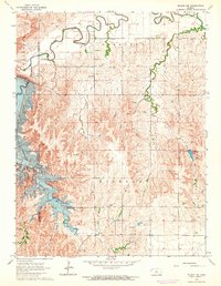
 1957 Great Bend1957 Print · USGSCentral Kansas at the peak of the postwar era shows a landscape of growing rail hubs and massive new water projects. Trace the routes of the Union Pacific through Hays or locate the newly formed shorelines of Cedar Bluff Reservoir and Kanopolis Reservoir.
 - 1958 Map of Great Bend
 1958 Great Bend1958 Print · USGSCentral Kansas in the late fifties reveals a landscape of high-plains agriculture and vital river crossings. Researchers can trace the development of regional hubs like Hays and Russell, or locate historic sites such as Fort Larned and the Cheyenne Bottoms wildlife area.2 unique versions available
 - 1959 Map of Beloit
 1959 Beloit1959 Print · USGSNorth Central Kansas at mid-century reveals a landscape shaped by river valleys and the expansion of massive water reservoirs. Genealogists and historians can trace the rail-town connections of Beloit and Norton or locate the site of the new Webster Dam.3 unique versions available
 - 1961 Map of Walker, 1962 Print
 1961 Walker1962 Print · USGSThe rural prairie along the Ellis and Russell County line is shown here in the early sixties, centered on the railroad community of Walker. Researchers can locate several country cemeteries and schools, including St Boniface Cem and Vincent Sch.2 unique versions available
 - 1961 Map of Russell SW, 1962 Print
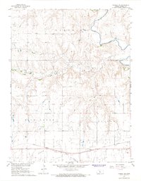
 1961 Russell SW1962 Print · USGSRussell County's rural landscape is captured in the early sixties as a center of oil extraction and riverside industry. Researchers can trace historic schools like Center Sch and Mt Brokaw Sch alongside an active Oil Field and the Smoky Hill River.2 unique versions available
 - 1961 Map of Homer, 1962 Print
 1961 Homer1962 Print · USGSRussell County during the early sixties shows a landscape shaped by petroleum and river-valley extraction. Genealogists can locate rural schoolhouses like Grant Sch and Hawley Sch alongside the tracks of the Union Pacific railroad.2 unique versions available
 - 1963 Map of Sylvan Grove, 1964 Print
 1963 Sylvan Grove1964 Print · USGSThe rural agricultural landscape of Lincoln and Russell counties comes to life in the early 1960s, centered on the riverfront town of Sylvan Grove. Researchers can locate the Union Pacific rail lines, family-history sites like Rosette Cem, and the Vonada Landing Field.
 - 1964 Map of Wilson NW
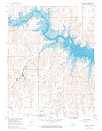
 1964 Wilson NW1964 Print · USGSThe Kansas landscape near the Russell and Lincoln county line was undergoing a transformation in the mid-sixties as the Wilson Reservoir began to fill. Landowners and historians can trace original terrain and drainage patterns at Hell Creek and West Creek before they were altered by the Wilson Dam.2 unique versions available
 - 1964 Map of Holyrood NW
 1964 Holyrood NW1964 Print · USGSMid-century Ellsworth and Barton counties reveal a landscape shaped by petroleum extraction and rural community hubs. Genealogists and historians can locate family landmarks like Palacky Cem and the Townhall alongside the Progress Oil Field.
 - 1967 Map of Russell NW, 1968 Print
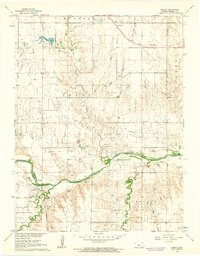
 1967 Russell NW1968 Print · USGSRussell County, Kansas, in the late 1960s was a landscape defined by its deep ties to the petroleum industry and the rail lines. Here, you can trace the extensive Paradise Oil Field, locate the Drive-in Theater, and follow the Union Pacific tracks past Balta.
 - 1967 Map of Dorrance NW, 1968 Print
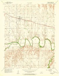
 1967 Dorrance NW1968 Print · USGSThe Saline River valley and the emerging shoreline of the Wilson Reservoir define this mid-century Kansas landscape. Researchers can trace the Union Pacific rail corridor and locate the Bunker Hill Cem near the town site.
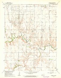
 - 1967 Map of Russell, 1968 Print
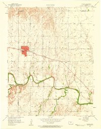
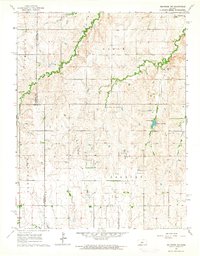
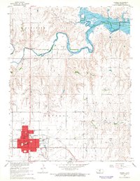 1967 Russell1968 Print · USGSMid-century Russell County is captured here just as the Wilson Reservoir began to alter the local drainage. Family history researchers can locate specific town institutions like Bickerdyke Sch, the local Cemetery, and landmarks along the Union Pacific line.
 - 1967 Map of Gorham, 1968 Print
 1967 Gorham1968 Print · USGSWestern Russell County was dominated by petroleum production and rail transit during the late sixties. Genealogists and historians can trace local families at St Marys Cem and explore industrial sites like the Gorham Oil Field and the Victoria-Pratt Airport (Abandoned).
 - 1967 Map of Hunter, 1969 Print
 1967 Hunter1969 Print · USGSThe rural plains of Mitchell and Lincoln counties are captured here in the late sixties, centered on the railroad town of Hunter. Genealogists and historians can trace local family landmarks such as Greenwood Union Cem, Spillman Cem, and the winding Bacon Creek.
Showing maps 1-25 of 195
Top cities of Russell County
- Russell historical maps
- Lucas historical maps
- Gorham historical maps
- Dorrance historical maps
- Luray historical maps
- Bunker Hill historical maps
See more
Frequently asked questions
- What are the different types of historical maps available for Russell County?
- What is the oldest map of Russell County?
- Where can I purchase historical maps of Russell County for my home or office?
- Where can I download high-res historical maps of Russell County?
- Are there historical topographic maps available for Russell County?
- Is there historical aerial imagery available for Russell County?
- Where are historical maps of Russell County sourced from?