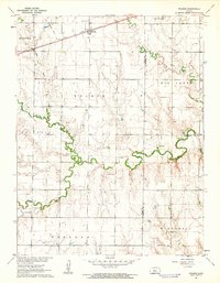
1961 Map of Walker
USGS Topo · Published 1962About this map
Walker and the surrounding townships of Herzog, Victoria, Freedom, and Winterset characterize this rural landscape in central Kansas. The Union Pacific railroad line runs through the northern portion of the map, while an Old Railroad Grade suggests earlier transportation patterns through the prairie. The hydrology is dominated by the meandering Big Creek and its tributary, North Fork Big Creek, which carve significant valleys across the terrain.
Find a feature on this map
19 named features on this map. Tap any name to fly to it.
Don’t see what you’re looking for? This feature index may not catch every label — zoom into the map to look around manually.
Map Details
Editions of this 1961 Walker Map
2 editions found
Other maps of this area

1896 · Russell
USGS Topo · 1:125,000

1896 · Hays
USGS Topo · 1:125,000

1955 · Great Bend
USGS Topo · 1:250,000

1957 · Great Bend
USGS Topo · 1:250,000

1958 · Great Bend
USGS Topo · 1:250,000

1961 · Catharine
USGS Topo · 1:24,000

1961 · Russell SW
USGS Topo · 1:24,000

1961 · Victoria
USGS Topo · 1:24,000

1967 · Russell NW
USGS Topo · 1:24,000
1967 · Gorham
USGS Topo · 1:24,000