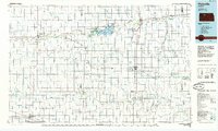
1985 Map of Plainville
USGS Topo · Published 1985About this map
Nicodemus and Hill City anchor the northwestern reaches of this mid-1980s landscape, where the agricultural grid of the High Plains is interrupted by deep river valleys and significant water management projects. The South Fork Solomon River flows eastward through the heart of the region, feeding the Webster Reservoir, which is flanked by the Webster State Wildlife Area and Webster State Park. This area serves as a critical hydrological hub for the surrounding drylands, supported further east by the Woodston Diversion State Wildlife Area.
Find a feature on this map
55 named features on this map. Tap any name to fly to it.
Don’t see what you’re looking for? This feature index may not catch every label — zoom into the map to look around manually.
Map Details
Editions of this 1985 Plainville Map
2 editions found
Other maps of this area

1893 · Ellis
USGS Topo · 1:125,000

1893 · Smith Center
USGS Topo · 1:125,000

1893 · Norton
USGS Topo · 1:125,000

1893 · Phillipsburg
USGS Topo · 1:125,000

1893 · Hill
USGS Topo · 1:125,000

1896 · Osborne
USGS Topo · 1:125,000

1896 · Russell
USGS Topo · 1:125,000

1896 · Hays
USGS Topo · 1:125,000

1896 · Plainville
USGS Topo · 1:125,000

1952 · Webster Dam
USGS Topo · 1:24,000