1960s Maps of McCreary County, Kentucky
Explore 4 historic maps of McCreary County from the 1960s. These maps offer a rare glimpse into what life looked like during the 1960s — showing old roads, neighborhoods, homes, and landmarks that have changed or disappeared over time.
Whether you're researching your family's past, planning a metal detecting trip, or studying how McCreary County's landscape evolved across the 1960s, these high-resolution maps are a powerful tool for exploring the history of this region.
- Focus on a specific era: All maps on this page are from the 1960s, giving you a focused view of this time period.
- See what’s changed: Compare century-old streets, trails, and buildings to today's modern landscape using overlays and satellite layers.
- Research with precision: Use these maps for genealogy, historical research, land use analysis, or educational projects.
- View, download, or print: Maps are fully viewable online in high resolution, and can be downloaded or printed for your own records.
Start exploring McCreary County's history through authentic maps from the 1960s. This is your window into the past.
McCreary County, KY maps
(4)- 1963 Map of Whitley City, 1966 Print
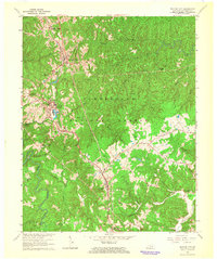 1963 Whitley City1966 Print · USGSMcCreary County's upland communities and the Southern railroad corridor are captured here during the mid-1960s. Genealogists and local historians can trace rural family-named landmarks such as Silerville, Hickory Grove Ch, and the Piney Knot Cem.
 - 1963 Map of Hail, 1966 Print
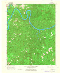 1963 Hail1966 Print · USGSMcCreary County and the Cumberland River are captured here in the early sixties, showing the interplay of the deep forest and the rising reservoir. Researchers can trace the Southern railroad line near Greenwood or locate historic congregation sites like Cave Creek Ch and Salem Ch.4 unique versions available
 - 1963 Map of Wiborg, 1966 Print
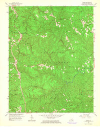 1963 Wiborg1966 Print · USGSMcCreary County communities line the Southern Railway in the early sixties, surrounded by the protected woods of the Cumberland National Forest. Genealogists and hikers can trace the paths to Roberts Chapel, Beulah Heights, and the remote cemetery at Hickenbottom.3 unique versions available
 - 1965 Map of Burnside, 1967 Print
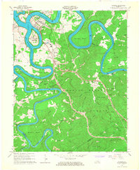 1965 Burnside1967 Print · USGSMid-century Pulaski County is defined by the winding waters of the Cumberland and South Fork rivers. Genealogists and hikers can locate family landmarks like Grave Hill Cemetery, the community at Sloans Valley, and the Alpine Recreation Area.3 unique versions available
End of results
Showing maps 1-4 of 4
Frequently asked questions
- What are the different types of historical maps available for McCreary County?
- What is the oldest map of McCreary County?
- Where can I purchase historical maps of McCreary County for my home or office?
- Where can I download high-res historical maps of McCreary County?
- Are there historical topographic maps available for McCreary County?
- Is there historical aerial imagery available for McCreary County?
- Where are historical maps of McCreary County sourced from?