1970s Maps of McCreary County, Kentucky
Explore 4 historic maps of McCreary County from the 1970s. These maps offer a rare glimpse into what life looked like during the 1970s — showing old roads, neighborhoods, homes, and landmarks that have changed or disappeared over time.
Whether you're researching your family's past, planning a metal detecting trip, or studying how McCreary County's landscape evolved across the 1970s, these high-resolution maps are a powerful tool for exploring the history of this region.
- Focus on a specific era: All maps on this page are from the 1970s, giving you a focused view of this time period.
- See what’s changed: Compare century-old streets, trails, and buildings to today's modern landscape using overlays and satellite layers.
- Research with precision: Use these maps for genealogy, historical research, land use analysis, or educational projects.
- View, download, or print: Maps are fully viewable online in high resolution, and can be downloaded or printed for your own records.
Start exploring McCreary County's history through authentic maps from the 1970s. This is your window into the past.
McCreary County, KY maps
(4)- 1979 Map of Hollyhill
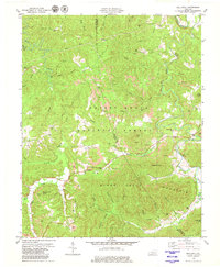 1979 Hollyhill1979 Print · USGSThe Cumberland Plateau in the late seventies reveals a landscape defined by forestry, coal mining, and small rural communities. Genealogists and historians can trace family landmarks like Granny Holt Knob, Laurel Cem, and churches such as New Liberty Ch.2 unique versions available
 - 1979 Map of Whitley City
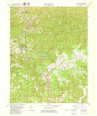 1979 Whitley City1979 Print · USGSThe Southern railway corridor defines this 1970s landscape through the heart of McCreary County and the National Forest. Genealogists and local historians can trace family-named sites like Gilreath Cem and rural centers such as Revelo, Marshes Siding, and Cal Hill Ch.2 unique versions available
 - 1979 Map of Cumberland Falls, 1980 Print
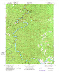 1979 Cumberland Falls1980 Print · USGSThe Cumberland River corridor in the late 1970s reveals a unique mix of recreation and resource extraction near the McCreary and Whitley County line. Genealogists and historians can trace local landmarks like Rock Branch Ch, the Ridener Cem, and the site of Tombstone Junction Amusement Park.2 unique versions available
 - 1979 Map of Jellico West, 1980 Print
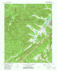 1979 Jellico West1980 Print · USGSMining and mountain life intersect along the Kentucky state line during the late seventies, where coal extraction shaped the local economy and geography. Researchers can find numerous family cemeteries like Lay Cem and landmarks such as the Stinking Creek Sch and Lookout Tower.2 unique versions available
End of results
Showing maps 1-4 of 4
Frequently asked questions
- What are the different types of historical maps available for McCreary County?
- What is the oldest map of McCreary County?
- Where can I purchase historical maps of McCreary County for my home or office?
- Where can I download high-res historical maps of McCreary County?
- Are there historical topographic maps available for McCreary County?
- Is there historical aerial imagery available for McCreary County?
- Where are historical maps of McCreary County sourced from?