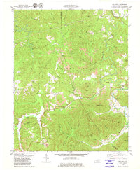
1979 Map of Hollyhill
USGS Topo · Published 1979About this map
Hollyhill serves as the focal point of this 1970s landscape, situated along the border of McCreary and Whitley counties. Much of the terrain is managed as part of the Daniel Boone National Forest, where steep ridges like Ryans Creek Mountain and Liza Mountain tower over winding waterways. The economy of the era is clearly visible through the numerous strip mines and smaller mines peppered throughout the hollows.
Find a feature on this map
50 named features on this map. Tap any name to fly to it.
Don’t see what you’re looking for? This feature index may not catch every label — zoom into the map to look around manually.
Map Details
Editions of this 1979 Hollyhill Map
2 editions found
Other maps of this area

1890 · Williamsburg
USGS Topo · 1:125,000

1894 · Williamsburg
USGS Topo · 1:125,000

1952 · Wofford
USGS Topo · 1:24,000

1952 · Hollyhill
USGS Topo · 1:24,000

1952 · Wiborg
USGS Topo · 1:24,000

1952 · Cumberland Falls
USGS Topo · 1:24,000

1952 · Williamsburg
USGS Topo · 1:24,000

1952 · Whitley City
USGS Topo · 1:24,000
1953 · Winfield
USGS Topo · 1:24,000
1953 · Jellico West
USGS Topo · 1:24,000