1990s Maps of Ascension Parish, Louisiana
Explore 13 historic maps of Ascension Parish from the 1990s. These maps offer a rare glimpse into what life looked like during the 1990s — showing old roads, neighborhoods, homes, and landmarks that have changed or disappeared over time.
Whether you're researching your family's past, planning a metal detecting trip, or studying how Ascension Parish's landscape evolved across the 1990s, these high-resolution maps are a powerful tool for exploring the history of this region.
- Focus on a specific era: All maps on this page are from the 1990s, giving you a focused view of this time period.
- See what’s changed: Compare century-old streets, trails, and buildings to today's modern landscape using overlays and satellite layers.
- Research with precision: Use these maps for genealogy, historical research, land use analysis, or educational projects.
- View, download, or print: Maps are fully viewable online in high resolution, and can be downloaded or printed for your own records.
Start exploring Ascension Parish's history through authentic maps from the 1990s. This is your window into the past.
Ascension Parish, LA maps
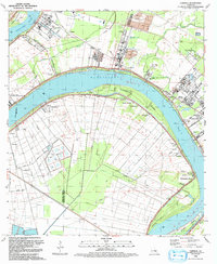
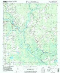
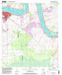
(13)- 1991 Map of Gonzales
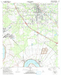 1991 Gonzales1991 Print · USGSAscension Parish is captured here in the early nineties as residential growth expanded outward from the river. Genealogists and local historians can trace family sites near Hope Haven Cem, the community at Hillaryville, and landmarks like Sacred Heart of Mary Ch.2 unique versions available
 - 1991 Map of French Settlement
 1991 French Settlement1991 Print · USGSThe Amite River basin of the early nineties shows a landscape of bayous and riverside villages. Genealogists can trace family names at Watson Cem and locate community anchors like St Joseph Ch and French Settlement.2 unique versions available
 - 1991 Map of Prairieville
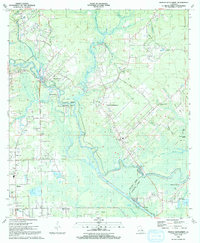
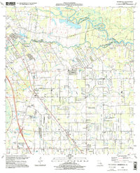
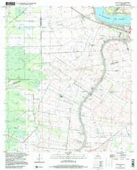
 1991 Prairieville1991 Print · USGSThe Ascension and East Baton Rouge Parish borderlands come alive in this early 1990s survey of the Bayou Manchac region. Trace family history through local landmarks like Prairieville Cem, St Amant, and Galvez Middle Sch.2 unique versions available
 - 1992 Map of St. Gabriel
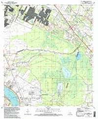 1992 St. Gabriel1992 Print · USGSThe river parishes south of Baton Rouge were a landscape of heavy industry and institutional centers in the early nineties. Genealogists and local researchers can trace the connections between St Gabriel and its historic St Raphael Cem, or locate landmarks like Iberville (Bayou Paul Sta).
 - 1992 Map of Carville
 1992 Carville1992 Print · USGSThe Mississippi River bends around Iberville and Ascension Parishes in the early nineties, revealing a landscape shaped by river transport and industry. Genealogists and historians can locate legacy sites like Mulberry Grove Plantation, the Gillis W Long Hansens Disease Center, and the historic Carville-White Castle Ferry.
 - 1995 Map of Prairieville, 1998 Print
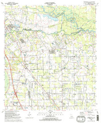
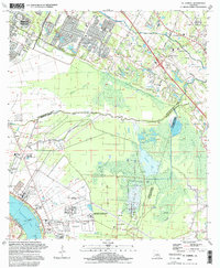
 1995 Prairieville1998 Print · USGSPrairieville and its neighboring settlements are captured in the mid-1990s during a period of steady residential growth between Baton Rouge and New Orleans. Genealogists and local historians can trace family landmarks like Richards Gardens of Memory Cem, the St John Ch, and the old crossroads at Hope Villa.
 - 1995 Map of St. Gabriel, 1998 Print
 1995 St. Gabriel1998 Print · USGSLouisiana's River Parishes meet the edge of the state capital in the late twentieth century, showing a landscape of bayous and industrial growth. Researchers can trace historic sites like St Gabriel Mission, the St Raphael Cem, and the rail stop at Iberville (Bayou Paul Sta).
 - 1998 Map of Gonzales, 2001 Print
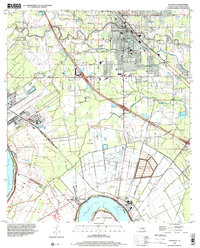 1998 Gonzales2001 Print · USGSAscension Parish at the close of the twentieth century shows a unique blend of riverfront industry and suburban growth near the Mississippi. Genealogists can locate family landmarks like Sacred Heart of Mary Ch, Burnside Cem, and the river-bend settlement of Hillaryville.
 - 1999 Map of French Settlement, 2000 Print
 1999 French Settlement2000 Print · USGSLouisiana's river country at the turn of the millennium shows a landscape shaped by the Amite River and its intricate bayous. Researchers can trace local history through sites like French Settlement, Port Vincent, and many parish landmarks like Shiloh Ch or Watson Cem.
 - 1999 Map of Belle Rose, 2000 Print
 1999 Belle Rose2000 Print · USGSAssumption and Ascension Parishes are shown at the turn of the millennium as the local economy balances traditional bayou settlement with modern industry. Trace the historical footprint of Donaldsonville and small communities like Belle Alliance or Sweet Home.
 - 1999 Map of Convent, 2000 Print
 1999 Convent2000 Print · USGSAlong the Mississippi River in the late nineties, the landscape of St. James Parish preserves its plantation-era layout amidst modern industry. Genealogists can trace family roots through riverfront settlements like Convent and landmark estates including Oak Alley Plantation and Belmont.
 - 1999 Map of Carville, 2000 Print
 1999 Carville2000 Print · USGSThe Mississippi River's winding course through Ascension and Iberville Parishes is captured here at the end of the twentieth century. Genealogists and local historians can trace riverfront settlements from Hohen Solms to Modeste, locating landmarks like Mulberry Grove Plantation and St Mary Ch.
 - 1999 Map of Donaldsonville, 2000 Print
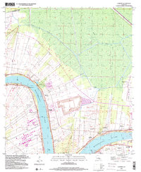
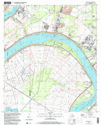
 1999 Donaldsonville2000 Print · USGSThe Mississippi River corridor near Donaldsonville appears at a moment of industrial change at the close of the century. Genealogists and local historians can trace legacy sites like Union Plantation, Buena Vista Cem, and Brulie Maurin.
End of results
Showing maps 1-13 of 13
Top cities of Ascension Parish
- Prairieville historical maps
- Gonzales historical maps
- Donaldsonville historical maps
- Sorrento historical maps
Frequently asked questions
- What are the different types of historical maps available for Ascension Parish?
- What is the oldest map of Ascension Parish?
- Where can I purchase historical maps of Ascension Parish for my home or office?
- Where can I download high-res historical maps of Ascension Parish?
- Are there historical topographic maps available for Ascension Parish?
- Is there historical aerial imagery available for Ascension Parish?
- Where are historical maps of Ascension Parish sourced from?