1930s Maps of Ascension Parish, Louisiana
Explore 6 historic maps of Ascension Parish from the 1930s. These maps offer a rare glimpse into what life looked like during the 1930s — showing old roads, neighborhoods, homes, and landmarks that have changed or disappeared over time.
Whether you're researching your family's past, planning a metal detecting trip, or studying how Ascension Parish's landscape evolved across the 1930s, these high-resolution maps are a powerful tool for exploring the history of this region.
- Focus on a specific era: All maps on this page are from the 1930s, giving you a focused view of this time period.
- See what’s changed: Compare century-old streets, trails, and buildings to today's modern landscape using overlays and satellite layers.
- Research with precision: Use these maps for genealogy, historical research, land use analysis, or educational projects.
- View, download, or print: Maps are fully viewable online in high resolution, and can be downloaded or printed for your own records.
Start exploring Ascension Parish's history through authentic maps from the 1930s. This is your window into the past.
Ascension Parish, LA maps
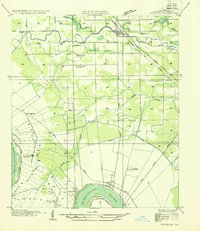
(6)- 1934 Map of Denham Springs
 1934 Denham Springs1934 Print · USGSLouisiana's river parishes come to life in the early 1930s as settlement spreads from the railroads into the bayous. Genealogists can trace family names at Broussard Grove Ch, locate the Rosenwald Sch, or find the old French Settlement Ferry crossing.2 unique versions available
 - 1935 Map of Gonzales
 1935 Gonzales1935 Print · USGSThe river parishes of Louisiana come alive in the mid-1930s, showing the vital connection between the winding Mississippi River and the growing interior. Genealogists can locate family landmarks like Conway Plantation or the industrial Belle Helene Refinery and St Paul Church.
 - 1936 Map of White Castle, 1937 Print
 1936 White Castle1937 Print · USGSThe Mississippi River corridor and its sprawling plantation estates are captured here in the mid-1930s. Researchers can trace family roots at Pierre Part Settlement or locate landmarks like the Leper Colony and St Marys Ch & Cem.2 unique versions available
 - 1939 Map of Denham Springs, 1942 Print
 1939 Denham Springs1942 Print · USGSLouisiana's river country comes alive in this pre-war survey of the Amite River basin during its transition to the modern highway era. Researchers can locate family roots at St Josephs Ch & Cem, track the old French Settlement Ferry, or find the Hoo Shoo Too Club.2 unique versions available
 - 1939 Map of Baton Rouge, 1947 Print
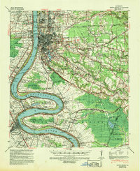 1939 Baton Rouge1947 Print · USGSBaton Rouge and the Mississippi River transition from a plantation-based economy to a burgeoning rail hub just before World War II. Genealogists and historians can trace the foundations of local communities through landmarks like Poplar Grove Plantation, Rose Hill Ch Sch & Cem, and the riverfront at Port Allen.4 unique versions available
 - 1939 Map of Donaldsonville, 1953 Print
 1939 Donaldsonville1953 Print · USGSLouisiana's river parishes are captured here in the late 1930s, showing a landscape defined by the winding Mississippi River and its rich agricultural traditions. Genealogists and historians can trace family roots through numerous combined school and church sites like Little Zion Sch Ch & Cem or the sprawling riverside Monroe Plantation.5 unique versions available
End of results
Showing maps 1-6 of 6
Top cities of Ascension Parish
- Prairieville historical maps
- Gonzales historical maps
- Donaldsonville historical maps
- Sorrento historical maps
Frequently asked questions
- What are the different types of historical maps available for Ascension Parish?
- What is the oldest map of Ascension Parish?
- Where can I purchase historical maps of Ascension Parish for my home or office?
- Where can I download high-res historical maps of Ascension Parish?
- Are there historical topographic maps available for Ascension Parish?
- Is there historical aerial imagery available for Ascension Parish?
- Where are historical maps of Ascension Parish sourced from?