1950s Maps of Ascension Parish, Louisiana
Explore 9 historic maps of Ascension Parish from the 1950s. These maps offer a rare glimpse into what life looked like during the 1950s — showing old roads, neighborhoods, homes, and landmarks that have changed or disappeared over time.
Whether you're researching your family's past, planning a metal detecting trip, or studying how Ascension Parish's landscape evolved across the 1950s, these high-resolution maps are a powerful tool for exploring the history of this region.
- Focus on a specific era: All maps on this page are from the 1950s, giving you a focused view of this time period.
- See what’s changed: Compare century-old streets, trails, and buildings to today's modern landscape using overlays and satellite layers.
- Research with precision: Use these maps for genealogy, historical research, land use analysis, or educational projects.
- View, download, or print: Maps are fully viewable online in high resolution, and can be downloaded or printed for your own records.
Start exploring Ascension Parish's history through authentic maps from the 1950s. This is your window into the past.
Ascension Parish, LA maps
(9)- 1953 Map of St. Gabriel, 1954 Print
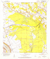 1953 St. Gabriel1954 Print · USGSThe river parishes of Louisiana come into focus in the 1950s, showing a landscape of rail lines and bayous at the edge of the Mississippi. Researchers can locate the Louisiana Prison Farm Camp "M" or trace family sites near St Gabriel, Sunshine, and Mt Carmel Ch.
 - 1953 Map of Prairieville, 1954 Print
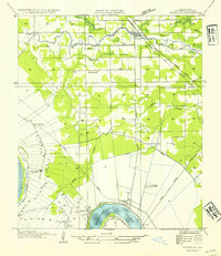
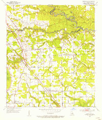 1953 Prairieville1954 Print · USGSAscension Parish during the early fifties shows a landscape of riverine bayous and burgeoning settlements along the newly modernized Airline Highway. Researchers can trace family roots through numerous landmarks like Oak Grove, Galvez, and local congregations at St Paul Ch and Zion Ch.
 - 1953 Map of French Settlement, 1954 Print
 1953 French Settlement1954 Print · USGSThe riverfront communities of Livingston and Ascension Parishes are shown in the early fifties, a time when the Amite River remained the primary geographic anchor. Genealogists can locate family burial sites at Felder Cem and Watson Cem or trace rural schools and churches like Port Vincent Sch and Shiloh Ch.2 unique versions available
 - 1953 Map of Gonzales, 1955 Print
 1953 Gonzales1955 Print · USGSAscension Parish at mid-century reveals a landscape defined by the winding Mississippi River and a dense network of bayous. Researchers can trace historic river landings like Point Houmas Landing and rural community hubs such as Burnside and Belle Helene.
 - 1953 Map of Carville, 1963 Print
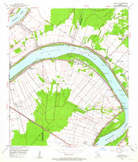 1953 Carville1963 Print · USGSThe riverbend country of Ascension and Iberville Parishes is captured here in the early fifties, showing the unique long-lot land patterns of the Mississippi. Genealogists can trace family footprints at the National Leprosarium or sites like Cannonburg Cem and St Phillips Ch.
 - 1954 Map of Petite Amite River
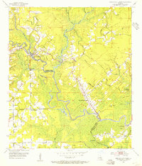
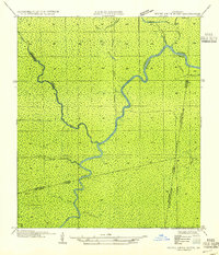 1954 Petite Amite River1954 Print · USGSThe swampy confluence of four Louisiana parishes is captured here in the mid-1930s as industrial footprints begin to fade. Researchers can trace the legacy of lost settlements like Garyville and Northern among the winding paths of the Petite Amite River and Bayou Reponds.
 - 1954 Map of Gonzales
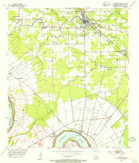
 1954 Gonzales1954 Print · USGSAscension Parish during the mid-fifties shows a landscape shaped by the Mississippi meanders and the arrival of modern highways. Local historians can trace the riverfront rail networks and family landmarks like Conway Plantation, Marchland, and the Belle Helene Refinery.
 - 1954 Map of Baton Rouge, 1974 Print
 1954 Baton Rouge1974 Print · USGSSoutheast Louisiana in the mid-fifties is captured here during a period of transition for its river and rail economies. Researchers can trace the path of the Mississippi River and find landmarks like the Bonnet Carre Spillway and Bayou Plaquemine.2 unique versions available
 - 1956 Map of Baton Rouge
 1956 Baton Rouge1956 Print · USGSSouth Louisiana at the height of the mid-century oil boom shows a landscape of river oxbows and rising industry. Researchers can trace family roots through river towns like Scotlandville or locate early industrial sites and Oil wells near Lake Maurepas.
End of results
Showing maps 1-9 of 9
Top cities of Ascension Parish
- Prairieville historical maps
- Gonzales historical maps
- Donaldsonville historical maps
- Sorrento historical maps
Frequently asked questions
- What are the different types of historical maps available for Ascension Parish?
- What is the oldest map of Ascension Parish?
- Where can I purchase historical maps of Ascension Parish for my home or office?
- Where can I download high-res historical maps of Ascension Parish?
- Are there historical topographic maps available for Ascension Parish?
- Is there historical aerial imagery available for Ascension Parish?
- Where are historical maps of Ascension Parish sourced from?