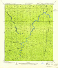
1954 Map of Petite Amite River
USGS Topo · Published 1954About this map
The Petite Amite River and Blind River meander through this dense wetland landscape at the convergence of Livingston, Ascension, St. John the Baptist, and St. James Parishes. Based on 1930s field examinations and aerial photography, the map reveals a wilderness defined by water, where drainage is the primary topographical feature. The presence of Garyville (Abandoned) and Northern (Abandoned) suggests the vestiges of early industry or settlement that once attempted to find purchase in this damp terrain. These former sites sit alongside a complex network of bayous, including Bayou Chene Blanc, Antoine Bayou, and Bayou Secret. The straight lines of the New River Canal provide a sharp contrast to the natural curves of Black Lake and Little Bayou Chene Blanc, illustrating early 20th-century water management and infrastructure in the Louisiana lowlands.
Find a feature on this map
21 named features on this map. Tap any name to fly to it.
Don’t see what you’re looking for? This feature index may not catch every label — zoom into the map to look around manually.
Map Details
Editions of this 1954 Petite Amite River Map
This is the sole edition of this map. No revisions or reprints were ever made.
Other maps of this area

1892 · Mount Airy
USGS Topo · 1:62,500

1892 · Donaldsonville
USGS Topo · 1:62,500

1934 · Denham Springs
USGS Topo · 1:62,500

1934 · Springfield
USGS Topo · 1:62,500

1939 · Springfield
USGS Topo · 1:62,500

1939 · Denham Springs
USGS Topo · 1:62,500

1939 · Donaldsonville
USGS Topo · 1:62,500

1946 · North of Garyville
USGS Topo · 1:31,680

1946 · Convent
USGS Topo · 1:31,680
1946 · Lutcher
USGS Topo · 1:31,680
Featured Places
- Livingston Parish, LA
- Ascension Parish, LA
- St. John the Baptist Parish, LA
- St. James Parish, LA
- United States