Old Maps of Ascension Parish, Louisiana for Genealogy
Trace your family roots with 107 historic maps of Ascension Parish. These high-res maps reveal old neighborhoods, homesites, landmarks, and streets — helping you uncover where your ancestors lived and how the area evolved over time.
- Explore historic neighborhoods: Identify where your relatives may have lived in the 1800s or 1900s.
- Compare maps over time: Trace the changes in streets, buildings, and landmarks for multi-generational research.
- Perfect for genealogy & ancestry research: Used by family historians and researchers to map out lineage and migration.
These maps are an incredible resource for exploring your personal connection to Ascension Parish's past.
Ascension Parish, LA maps
(107)- 1892 Map of Mount Airy
 1892 Mount Airy1892 Print · USGSThe lower Mississippi River corridor is captured here in the early 1890s, showcasing the traditional long-lot plantations and burgeoning rail towns. Researchers can trace the early footprints of Edgard and Mt Airy or locate family-named landmarks like Pauline and Johnson along the river's edge.4 unique versions available
 - 1892 Map of Donaldsonville
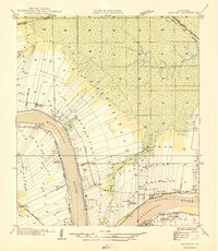
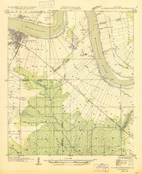
 1892 Donaldsonville1892 Print · USGSLouisiana river life in the early 1890s centered on the great meanders and landings of the river parishes. Genealogists and historians can trace the early footprints of Donaldsonville, locate the Indian Mounds, and see the impact of the Nita Crevasse on the shoreline.12 unique versions available
 - 1908 Map of Baton Rouge, 1921 Print
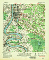
 1908 Baton Rouge1921 Print · USGSBaton Rouge and the surrounding river parishes are captured here at the dawn of the twentieth century, as the railroad network began to rival the river. Genealogists can locate family landmarks like Harelsons Store, Morning Star Church, and the community of Benton's.2 unique versions available
 - 1934 Map of Denham Springs
 1934 Denham Springs1934 Print · USGSLouisiana's river parishes come to life in the early 1930s as settlement spreads from the railroads into the bayous. Genealogists can trace family names at Broussard Grove Ch, locate the Rosenwald Sch, or find the old French Settlement Ferry crossing.2 unique versions available
 - 1935 Map of Gonzales
 1935 Gonzales1935 Print · USGSThe river parishes of Louisiana come alive in the mid-1930s, showing the vital connection between the winding Mississippi River and the growing interior. Genealogists can locate family landmarks like Conway Plantation or the industrial Belle Helene Refinery and St Paul Church.
 - 1936 Map of White Castle, 1937 Print
 1936 White Castle1937 Print · USGSThe Mississippi River corridor and its sprawling plantation estates are captured here in the mid-1930s. Researchers can trace family roots at Pierre Part Settlement or locate landmarks like the Leper Colony and St Marys Ch & Cem.2 unique versions available
 - 1939 Map of Denham Springs, 1942 Print
 1939 Denham Springs1942 Print · USGSLouisiana's river country comes alive in this pre-war survey of the Amite River basin during its transition to the modern highway era. Researchers can locate family roots at St Josephs Ch & Cem, track the old French Settlement Ferry, or find the Hoo Shoo Too Club.2 unique versions available
 - 1939 Map of Baton Rouge, 1947 Print
 1939 Baton Rouge1947 Print · USGSBaton Rouge and the Mississippi River transition from a plantation-based economy to a burgeoning rail hub just before World War II. Genealogists and historians can trace the foundations of local communities through landmarks like Poplar Grove Plantation, Rose Hill Ch Sch & Cem, and the riverfront at Port Allen.4 unique versions available
 - 1939 Map of Donaldsonville, 1953 Print
 1939 Donaldsonville1953 Print · USGSLouisiana's river parishes are captured here in the late 1930s, showing a landscape defined by the winding Mississippi River and its rich agricultural traditions. Genealogists and historians can trace family roots through numerous combined school and church sites like Little Zion Sch Ch & Cem or the sprawling riverside Monroe Plantation.5 unique versions available
 - 1946 Map of Convent
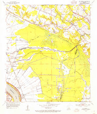
 1946 Convent1946 Print · USGSSt. James Parish life in the 1940s centers on the riverfront plantations and rail-connected settlements along the Mississippi. Researchers can trace family sites near St Josephs Plantation, Oak Alley Plantation, and the community at Convent.
 - 1946 Map of Petite Amite River
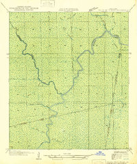 1946 Petite Amite River1946 Print · USGSCoastal Louisiana at the end of the depression era is revealed here as a wild corridor of bayous and shifting parish lines. Trace the path of the Garville Northern (Abandoned) railroad as it cuts through the swamps near Blind River and Black Lake.
 - 1947 Map of Donaldsonville
 1947 Donaldsonville1947 Print · USGSThe Mississippi River corridor near Donaldsonville comes to life in this mid-century survey of the river's winding path and industrial shoreline. Researchers can trace the rail lines of the Texas and Pacific, find the Saulsberg Refinery, and locate rural landmarks like the Brulie Maurin Sch.
 - 1947 Map of Sorrento
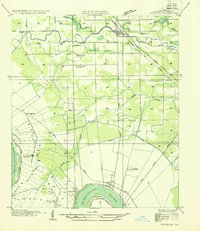
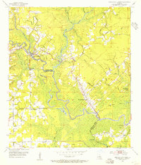
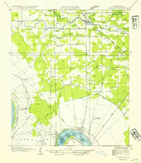
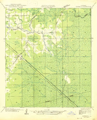 1947 Sorrento1947 Print · USGSLouisiana's Ascension Parish is captured here in the mid-1940s as a landscape of vital rail corridors and complex drainage systems. Genealogists and historians can trace old homesteads and routes through Sorrento, Saint Amant, and McElroy along the Airline Highway.
 - 1953 Map of St. Gabriel, 1954 Print
 1953 St. Gabriel1954 Print · USGSThe river parishes of Louisiana come into focus in the 1950s, showing a landscape of rail lines and bayous at the edge of the Mississippi. Researchers can locate the Louisiana Prison Farm Camp "M" or trace family sites near St Gabriel, Sunshine, and Mt Carmel Ch.
 - 1953 Map of Prairieville, 1954 Print
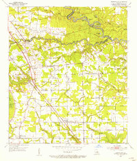 1953 Prairieville1954 Print · USGSAscension Parish during the early fifties shows a landscape of riverine bayous and burgeoning settlements along the newly modernized Airline Highway. Researchers can trace family roots through numerous landmarks like Oak Grove, Galvez, and local congregations at St Paul Ch and Zion Ch.
 - 1953 Map of French Settlement, 1954 Print
 1953 French Settlement1954 Print · USGSThe riverfront communities of Livingston and Ascension Parishes are shown in the early fifties, a time when the Amite River remained the primary geographic anchor. Genealogists can locate family burial sites at Felder Cem and Watson Cem or trace rural schools and churches like Port Vincent Sch and Shiloh Ch.2 unique versions available
 - 1953 Map of Gonzales, 1955 Print
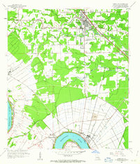
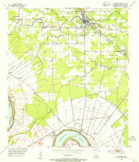 1953 Gonzales1955 Print · USGSAscension Parish at mid-century reveals a landscape defined by the winding Mississippi River and a dense network of bayous. Researchers can trace historic river landings like Point Houmas Landing and rural community hubs such as Burnside and Belle Helene.
 - 1953 Map of Carville, 1963 Print
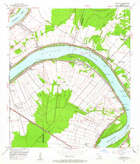 1953 Carville1963 Print · USGSThe riverbend country of Ascension and Iberville Parishes is captured here in the early fifties, showing the unique long-lot land patterns of the Mississippi. Genealogists can trace family footprints at the National Leprosarium or sites like Cannonburg Cem and St Phillips Ch.
 - 1954 Map of Petite Amite River
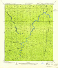 1954 Petite Amite River1954 Print · USGSThe swampy confluence of four Louisiana parishes is captured here in the mid-1930s as industrial footprints begin to fade. Researchers can trace the legacy of lost settlements like Garyville and Northern among the winding paths of the Petite Amite River and Bayou Reponds.
 - 1954 Map of Gonzales
 1954 Gonzales1954 Print · USGSAscension Parish during the mid-fifties shows a landscape shaped by the Mississippi meanders and the arrival of modern highways. Local historians can trace the riverfront rail networks and family landmarks like Conway Plantation, Marchland, and the Belle Helene Refinery.
 - 1954 Map of Baton Rouge, 1974 Print
 1954 Baton Rouge1974 Print · USGSSoutheast Louisiana in the mid-fifties is captured here during a period of transition for its river and rail economies. Researchers can trace the path of the Mississippi River and find landmarks like the Bonnet Carre Spillway and Bayou Plaquemine.2 unique versions available
 - 1956 Map of Baton Rouge
 1956 Baton Rouge1956 Print · USGSSouth Louisiana at the height of the mid-century oil boom shows a landscape of river oxbows and rising industry. Researchers can trace family roots through river towns like Scotlandville or locate early industrial sites and Oil wells near Lake Maurepas.
 - 1961 Map of Gonzales, 1963 Print
 1961 Gonzales1963 Print · USGSThe Ascension Parish landscape in the early sixties shows the shift from river-based plantation culture to a modern rail and industrial corridor. Genealogists and local historians can trace family landmarks like Belle Helene Plantation, St Landry Ch, and Lusk Cem.3 unique versions available
 - 1961 Map of Baton Rouge, 1966 Print
 1961 Baton Rouge1966 Print · USGSSoutheastern Louisiana in the early sixties remains a landscape of deep river bends and sprawling coastal lakes. Genealogists and historians can trace the rail-and-river economy through landmarks like Free-Nigger Point, Donaldsonville, and the Illinois Central Railroad.
 - 1962 Map of Baton Rouge
 1962 Baton Rouge1962 Print · USGSSouth Louisiana in the early sixties reveals a landscape of river-bend parishes and emerging interstate corridors. Genealogists and historians can trace family roots through historic river towns like Donaldsonville and Plaquemine, or follow the path of the Illinois Central Railroad through the swamp basins.
Showing maps 1-25 of 107
Top cities of Ascension Parish
- Prairieville historical maps
- Gonzales historical maps
- Donaldsonville historical maps
- Sorrento historical maps
Frequently asked questions
- What are the different types of historical maps available for Ascension Parish?
- What is the oldest map of Ascension Parish?
- Where can I purchase historical maps of Ascension Parish for my home or office?
- Where can I download high-res historical maps of Ascension Parish?
- Are there historical topographic maps available for Ascension Parish?
- Is there historical aerial imagery available for Ascension Parish?
- Where are historical maps of Ascension Parish sourced from?