1960s Maps of Beauregard Parish, Louisiana
Explore 8 historic maps of Beauregard Parish from the 1960s. These maps offer a rare glimpse into what life looked like during the 1960s — showing old roads, neighborhoods, homes, and landmarks that have changed or disappeared over time.
Whether you're researching your family's past, planning a metal detecting trip, or studying how Beauregard Parish's landscape evolved across the 1960s, these high-resolution maps are a powerful tool for exploring the history of this region.
- Focus on a specific era: All maps on this page are from the 1960s, giving you a focused view of this time period.
- See what’s changed: Compare century-old streets, trails, and buildings to today's modern landscape using overlays and satellite layers.
- Research with precision: Use these maps for genealogy, historical research, land use analysis, or educational projects.
- View, download, or print: Maps are fully viewable online in high resolution, and can be downloaded or printed for your own records.
Start exploring Beauregard Parish's history through authentic maps from the 1960s. This is your window into the past.
Beauregard Parish, LA maps
(8)- 1960 Map of De Ridder, 1961 Print
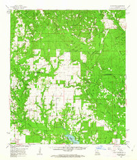
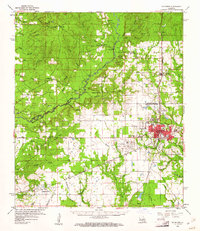 1960 De Ridder1961 Print · USGSBeauregard Parish at the start of the 1960s shows a landscape shaped by timber, rail, and emerging oil interests. Genealogists can trace family roots through rural landmarks like Lillie Ch, Knight, and the settlements of Rosepine and Bon Ami.2 unique versions available
 - 1961 Map of Dry Creek, 1963 Print
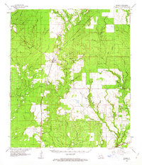
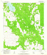 1961 Dry Creek1963 Print · USGSBeauregard Parish in the early sixties was a landscape of timber tracts and winding bayous centered on the community of Dry Creek. Genealogists and historians can trace the paths of an Old Railroad Grade or locate rural landmarks like Shiloh Ch and Green Cem.2 unique versions available
 - 1961 Map of Sugartown, 1963 Print
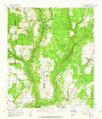
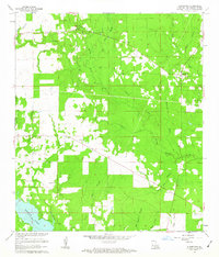 1961 Sugartown1963 Print · USGSSugartown and the surrounding timberlands of Beauregard Parish are captured here in the early sixties as rural life centered on the local churches and creek crossings. Genealogists and local historians can locate several family and community sites, including Cole Cem, Smyrna Ch, and the Sugartown Lookout Tower.2 unique versions available
 - 1961 Map of Mittie, 1963 Print
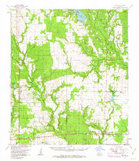
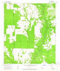 1961 Mittie1963 Print · USGSAllen Parish life in the early sixties centers on the winding Whisky Chitto Creek and the small crossroads of Mittie. Genealogists and local historians can trace family roots at the Simmons Settlement or locate landmarks like Cherry Grove Ch and the Simmons Cem.3 unique versions available
 - 1961 Map of Sugartown, 1963 Print
 1961 Sugartown1963 Print · USGSCentral Louisiana in the early sixties was a landscape of timber stands and winding creek bottoms along the Vernon and Beauregard Parish border. Genealogists and historians can trace rural life through landmarks like Lone Star Sch, Wisby Memorial Ch Cem, and the Sugartown Lookout Tower.2 unique versions available
 - 1961 Map of Singer, 1963 Print
 1961 Singer1963 Print · USGSBeauregard Parish in the early sixties is a landscape of timbered branches and emerging oil fields along the Southern Kansas City railroad. Genealogists and local historians can locate rural landmarks like Holly Grove Ch, Juanita, and the Oretta Cem.2 unique versions available
 - 1961 Map of Oberlin, 1963 Print
 1961 Oberlin1963 Print · USGSAllen Parish during the early sixties shows a landscape of timber and oil development along the MISSOURI PACIFIC. Genealogists can trace family roots at Simmons Settlement and historic sites like Pine Chapel Cem or St Johns Ch.2 unique versions available
 - 1961 Map of Reeves, 1963 Print
 1961 Reeves1963 Print · USGSSouthwest Louisiana in the early sixties reveals a landscape of growing petroleum production and established rail junctions. Genealogists and local historians can trace family locations near Longville, Reeves, and Fulton, or find old landmarks like Magnolia Ch and Frusha Cem.2 unique versions available
End of results
Showing maps 1-8 of 8
Top cities of Beauregard Parish
Frequently asked questions
- What are the different types of historical maps available for Beauregard Parish?
- What is the oldest map of Beauregard Parish?
- Where can I purchase historical maps of Beauregard Parish for my home or office?
- Where can I download high-res historical maps of Beauregard Parish?
- Are there historical topographic maps available for Beauregard Parish?
- Is there historical aerial imagery available for Beauregard Parish?
- Where are historical maps of Beauregard Parish sourced from?