1990s Maps of Bossier Parish, Louisiana
Explore 3 historic maps of Bossier Parish from the 1990s. These maps offer a rare glimpse into what life looked like during the 1990s — showing old roads, neighborhoods, homes, and landmarks that have changed or disappeared over time.
Whether you're researching your family's past, planning a metal detecting trip, or studying how Bossier Parish's landscape evolved across the 1990s, these high-resolution maps are a powerful tool for exploring the history of this region.
- Focus on a specific era: All maps on this page are from the 1990s, giving you a focused view of this time period.
- See what’s changed: Compare century-old streets, trails, and buildings to today's modern landscape using overlays and satellite layers.
- Research with precision: Use these maps for genealogy, historical research, land use analysis, or educational projects.
- View, download, or print: Maps are fully viewable online in high resolution, and can be downloaded or printed for your own records.
Start exploring Bossier Parish's history through authentic maps from the 1990s. This is your window into the past.
Bossier Parish, LA maps
(3)- 1998 Map of Bossier City, 2003 Print
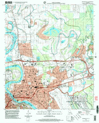 1998 Bossier City2003 Print · USGSBossier City and Shreveport's suburban expansion is captured in the late nineties as the urban landscape pushed into the Red River's oxbows. Researchers can locate family landmarks such as Greenwood Cemetery, St Judes Ch, and Rusheon Jr High Sch.
 - 1998 Map of Doyline, 2004 Print
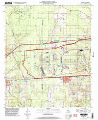 1998 Doyline2004 Print · USGSNorth Louisiana’s industrial and rural landscapes meet in the late nineties, showcasing the intersection of military infrastructure and small-town life. Researchers can locate family landmarks like Jim Davis Cem and Allen Town Cem or trace the vast Louisiana Army Ammunition Plant.
 - 1999 Map of Eastwood, 2000 Print
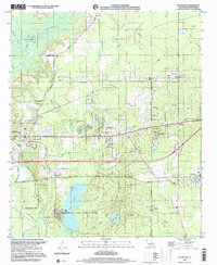 1999 Eastwood2000 Print · USGSBossier Parish at the close of the century shows a unique landscape where military aviation and bayou country meet. Researchers can trace family history through numerous rural landmarks like St Johns Ch, Fillmore Cem, and the sprawling grounds of Barksdale Air Force Base.
End of results
Showing maps 1-3 of 3
Top cities of Bossier Parish
- Bossier City historical maps
- Haughton historical maps
- Benton historical maps
- Plain Dealing historical maps
Frequently asked questions
- What are the different types of historical maps available for Bossier Parish?
- What is the oldest map of Bossier Parish?
- Where can I purchase historical maps of Bossier Parish for my home or office?
- Where can I download high-res historical maps of Bossier Parish?
- Are there historical topographic maps available for Bossier Parish?
- Is there historical aerial imagery available for Bossier Parish?
- Where are historical maps of Bossier Parish sourced from?