Old Maps of Bossier Parish, Louisiana for Metal Detecting
Plan your next treasure hunt with 222 historic maps of Bossier Parish. Find old homesites, ghost towns, trails, and gathering spots that may be lost to time — perfect for identifying promising metal detecting locations.
- Locate forgotten sites: Uncover places like long-lost settlements, abandoned rail lines, or gathering spots.
- Plan better hunts: Use map overlays combined with LiDAR or satellite views to narrow in on historically rich areas.
- Made for detectorists: Thousands of hobbyists use these maps to discover relics, coins, and hidden history.
Use these historic maps to boost your research and find new opportunities beneath the surface of Bossier Parish.
Bossier Parish, LA maps
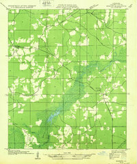
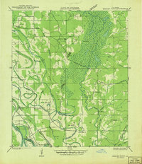
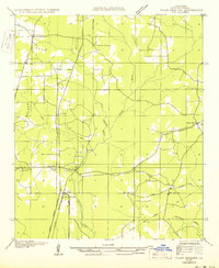
(222)- 1922 Map of Sarepta, 1954 Print
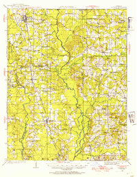 1922 Sarepta1954 Print · USGSUpper Webster Parish in the early 1920s is a landscape of creek-bottom communities and timber-belt settlements. Genealogists can trace family footprints across dozens of rural landmarks, from the Manuel Garcia Grant to Sykes Ferry and Old Shongaloo Church.
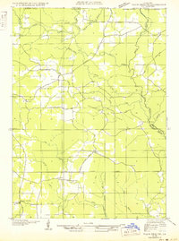
 - 1924 Map of Sarepta
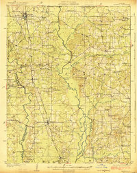 1924 Sarepta1924 Print · USGSNorthern Louisiana during the early twenties is a landscape of rail-linked towns and bayou crossings. Genealogists and local historians can trace family roots through numerous rural landmarks like Beulahs Mt Church, Wise Store, and Old Shongaloo School.
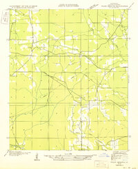
 - 1932 Map of Bossier SE
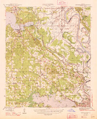
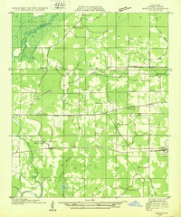 1932 Bossier SE1932 Print · USGSBossier Parish in the early 1930s is a landscape of growing military tracts and rural crossroads settlements. Genealogists can trace family footprints through numerous local landmarks, including Cedar Grove Sch, Rocky Mount Ch, and the Harper cemetery.
 - 1932 Map of Hosston NE
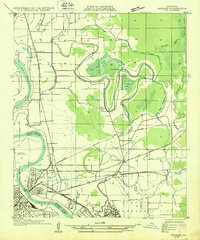
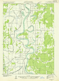 1932 Hosston NE1932 Print · USGSThe Red River floodplain in Northwest Louisiana was a landscape of ferries and oxbow lakes in the early 1930s. Researchers can trace rural life through landmarks like Missionary Ferry, Miller Bluff Ch, and the town of Hosston.
 - 1932 Map of Bossier NE
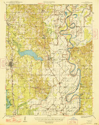
 1932 Bossier NE1932 Print · USGSBossier Parish in the early 1930s reveals a landscape defined by its bayous and timber economy. Genealogists and historians can locate early social hubs like Bellevue and Bethlehem Ch or trace the route of the narrow-gage Lumber R R.
 - 1932 Map of Bossier SW
 1932 Bossier SW1932 Print · USGSShreveport and Bossier City appear during an era of significant growth, with the newly established Barksdale Field taking shape. Genealogists can trace family footprints at Vanceville, Scottville, and churches like Friendship Ch.
 - 1932 Map of Shreveport SE
 1932 Shreveport SE1932 Print · USGSNorthwest Louisiana's river country is captured here in the early thirties, showcasing a landscape defined by shifting bayous and new infrastructure. Trace the early growth of Shreveport alongside the Albany Ferry and landmarks like St Matthews Ch and the Rosenwald Sch.
 - 1932 Map of Hosston SE
 1932 Hosston SE1932 Print · USGSCaddo and Bossier Parishes are captured here in the early thirties along the winding Red River. Local historians can locate river crossings like Peru Ferry and a network of community anchors including Rosenwald Sch and Gilliam.
 - 1932 Map of Bossier NW
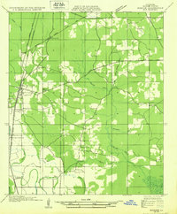 1932 Bossier NW1932 Print · USGSBossier Parish at the start of the 1930s shows a landscape defined by its bayous and the emerging energy industry. Genealogists can locate family landmarks such as Linton, Star Sch, and the Macedonia Ch along the winding banks of Whiteoak Bayou.
 - 1932 Map of Shreveport NE
 1932 Shreveport NE1932 Print · USGSCaddo and Bossier parishes are captured in the early 1930s, showing a river-bottom landscape of shifting bayous and cotton-country settlements. Genealogists and local historians can trace family roots through landmarks like the Rosenwald Sch, St James Ch, and the Briarfield Ferry crossing.
 - 1938 Map of Arnsberg
 1938 Arnsberg1938 Print · USGSBossier Parish at the end of the 1930s reveals a landscape of dense river meanders and rail-side settlements. Trace family roots and vanished landmarks like Arnsberg, Taylortown, and rural schools such as Marshall Hill Sch or Indian Hill Sch.
 - 1941 Map of East Point
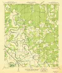
 1941 East Point1941 Print · USGSThe Red River Valley bottomlands are captured here in the late 1930s, showing a network of riverfront settlements and rural parish life. Researchers can trace family history through numerous landmarks like Elizabeth Church, Crichton School, and the St Marks Cemetery near the Bayou Toulon.
 - 1941 Map of Forbing
 1941 Forbing1941 Print · USGSThe outskirts of Shreveport and the shifting bends of the Red River come to life just before the mid-century expansion. Genealogists and historians can locate specific rural institutions such as Centenary College, Hood Cem, and the Good Hope Sch among the river's many points and bayous.
 - 1941 Map of Bossier Point
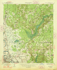
 1941 Bossier Point1941 Print · USGSThe marshlands and bottomlands of Bossier Parish come alive in the early 1940s, showing a landscape defined by the shifting waters of Lake Bistineau. Genealogists can trace family footprints at Fairview Cem or locate rural landmarks like Bear Island Sch and the Burkett Bridge.
 - 1947 Map of Ringgold
 1947 Ringgold1947 Print · USGSNorthwestern Louisiana comes to life in the 1940s, centered on the growing town of Ringgold and the expansive waters of LAKE BISTINEAU. Trace local roots through rural landmarks like the NEW SALT WORKS, St Johns Ch, and the Ogden Spur railroad line.
 - 1947 Map of Minden, 1964 Print
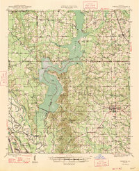
 1947 Minden1964 Print · USGSMinden and the surrounding Webster Parish countryside are captured here in the mid-1940s, during a period of significant industrialization. Genealogists and local historians can trace family-named sites and rural centers like the Louisiana Ordnance Plant, Doyline, and Shady Grove Cem.2 unique versions available
 - 1948 Map of Coushatta
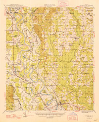 1948 Coushatta1948 Print · USGSRed River Parish and the surrounding hill country are captured here just after the war, showing the intricate river-and-rail network. Genealogists can trace family names through dozens of landmarks like Elizabeth Sch, St Pauls Cem, and Hall Summit.
 - 1948 Map of Mooringsport
 1948 Mooringsport1948 Print · USGSNorthwest Louisiana's oil and river country is captured here during the late 1940s, showing the early growth of Mooringsport and Oil City. Researchers can trace rural lineages through numerous local landmarks like the Evening Star Sch and Albany Ferry.
 - 1948 Map of Vivian
 1948 Vivian1948 Print · USGSUpper Caddo Parish in the late 1940s is defined by the winding Red River and a thriving rail-and-oil economy. Genealogists can trace family roots through numerous rural landmarks like the Oil Refinery near Lewis, the Miller Bluff Ferry, and Egypt Hill Cem.
 - 1948 Map of Bossier City
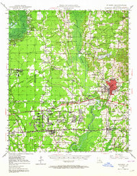
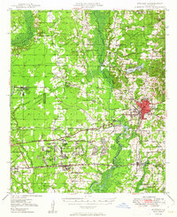
 1948 Bossier City1948 Print · USGSNorthwestern Louisiana during the late 1940s reveals a landscape shaped by the Red River and the expansion of the Bossier City area. Researchers can trace rural family sites near Benton or locate historical landmarks like Barksdale Field and Red River Ch.
 - 1948 Map of Caspiana
 1948 Caspiana1948 Print · USGSNorthwest Louisiana south of Shreveport is captured here in the late 1940s as the river-and-rail economy shaped the Red River Valley. Genealogists can trace family footprints across dozens of rural landmarks like Blenheim Sch, Robinson Chapel, and Evergreen Cem.
 - 1949 Map of Minden
 1949 Minden1949 Print · USGSNorthwest Louisiana's hill country and bayous are caught at a point of industrial transition just after the war. Researchers can trace the massive Louisiana Ordnance Plant, the bustling junction at Sibley, and local burial sites like Ratcliff Cemetery.
 - 1950 Map of Plain Dealing SW
 1950 Plain Dealing SW1950 Print · USGSBossier Parish at mid-century shows a landscape shaped by rail transport and rural community hubs like Collinsburg and Rocky Mount. Genealogists and historians can locate family-named sites such as Booker Chapel, New Light Sch, and the St Louis Southwestern RR corridor.
 - 1950 Map of Plain Dealing NE
 1950 Plain Dealing NE1950 Print · USGSUpper Bossier Parish was a landscape of timber and oil during the mid-century, defined by small settlements and resource extraction. Genealogists and researchers can trace local landmarks like Elizabeth Sch, the Goodwin Sawmill, and the Carterville Oil Field.
 - 1950 Map of Plain Dealing SE
 1950 Plain Dealing SE1950 Print · USGSBossier Parish during the mid-century transition preserves a detailed look at rural life centered around the Magnolia Lumber RR. Genealogists and local historians can locate several family churches and schools, such as Galilee Sch, Aimwell Ch, and Springhill Ch.
Showing maps 1-25 of 222
Top cities of Bossier Parish
- Bossier City historical maps
- Haughton historical maps
- Benton historical maps
- Plain Dealing historical maps
Frequently asked questions
- What are the different types of historical maps available for Bossier Parish?
- What is the oldest map of Bossier Parish?
- Where can I purchase historical maps of Bossier Parish for my home or office?
- Where can I download high-res historical maps of Bossier Parish?
- Are there historical topographic maps available for Bossier Parish?
- Is there historical aerial imagery available for Bossier Parish?
- Where are historical maps of Bossier Parish sourced from?