1960s Maps of Bossier Parish, Louisiana
Explore 3 historic maps of Bossier Parish from the 1960s. These maps offer a rare glimpse into what life looked like during the 1960s — showing old roads, neighborhoods, homes, and landmarks that have changed or disappeared over time.
Whether you're researching your family's past, planning a metal detecting trip, or studying how Bossier Parish's landscape evolved across the 1960s, these high-resolution maps are a powerful tool for exploring the history of this region.
- Focus on a specific era: All maps on this page are from the 1960s, giving you a focused view of this time period.
- See what’s changed: Compare century-old streets, trails, and buildings to today's modern landscape using overlays and satellite layers.
- Research with precision: Use these maps for genealogy, historical research, land use analysis, or educational projects.
- View, download, or print: Maps are fully viewable online in high resolution, and can be downloaded or printed for your own records.
Start exploring Bossier Parish's history through authentic maps from the 1960s. This is your window into the past.
Bossier Parish, LA maps
(3)- 1960 Map of El Dorado
 1960 El Dorado1960 Print · USGSSouth Central Arkansas in the late fifties was a hub of energy production and defense industry. Researchers can trace the extensive Oil and Gas Fields around El Dorado or locate family landmarks like Old Park Cem and New Hope Church.
 - 1960 Map of North Highlands
 1960 North Highlands1960 Print · USGSShreveport and its northern suburbs reached toward the Red River in the early sixties as new infrastructure transformed the Caddo Parish landscape. Genealogists and local historians can trace the foundations of neighborhoods near Northside Sch, locate family plots at Walker Hill Cem, and follow the old rail lines of the Texas and Pacific.2 unique versions available
 - 1960 Map of Bossier City
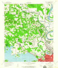
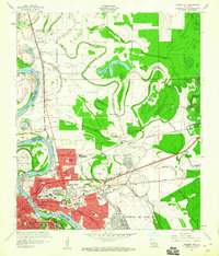 1960 Bossier City1960 Print · USGSBossier City and Shreveport are shown at a peak of post-war growth as the urban center expands toward the Red River. Researchers can trace mid-century neighborhoods near Plantation Park Sch or locate rural landmarks like Mt Zion Ch and Vanceville.2 unique versions available
End of results
Showing maps 1-3 of 3
Top cities of Bossier Parish
- Bossier City historical maps
- Haughton historical maps
- Benton historical maps
- Plain Dealing historical maps
Frequently asked questions
- What are the different types of historical maps available for Bossier Parish?
- What is the oldest map of Bossier Parish?
- Where can I purchase historical maps of Bossier Parish for my home or office?
- Where can I download high-res historical maps of Bossier Parish?
- Are there historical topographic maps available for Bossier Parish?
- Is there historical aerial imagery available for Bossier Parish?
- Where are historical maps of Bossier Parish sourced from?