1940s Maps of Caddo Parish, Louisiana
Explore 20 historic maps of Caddo Parish from the 1940s. These maps offer a rare glimpse into what life looked like during the 1940s — showing old roads, neighborhoods, homes, and landmarks that have changed or disappeared over time.
Whether you're researching your family's past, planning a metal detecting trip, or studying how Caddo Parish's landscape evolved across the 1940s, these high-resolution maps are a powerful tool for exploring the history of this region.
- Focus on a specific era: All maps on this page are from the 1940s, giving you a focused view of this time period.
- See what’s changed: Compare century-old streets, trails, and buildings to today's modern landscape using overlays and satellite layers.
- Research with precision: Use these maps for genealogy, historical research, land use analysis, or educational projects.
- View, download, or print: Maps are fully viewable online in high resolution, and can be downloaded or printed for your own records.
Start exploring Caddo Parish's history through authentic maps from the 1940s. This is your window into the past.
Caddo Parish, LA maps
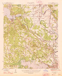
(20)- 1941 Map of East Point
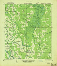
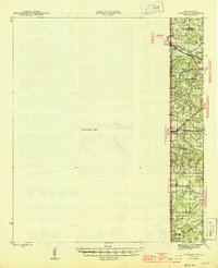
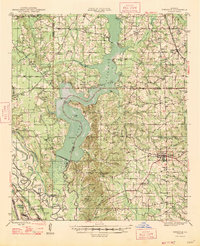
 1941 East Point1941 Print · USGSThe Red River Valley bottomlands are captured here in the late 1930s, showing a network of riverfront settlements and rural parish life. Researchers can trace family history through numerous landmarks like Elizabeth Church, Crichton School, and the St Marks Cemetery near the Bayou Toulon.
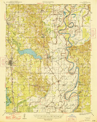
 - 1941 Map of Forbing
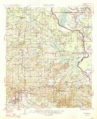
 1941 Forbing1941 Print · USGSThe outskirts of Shreveport and the shifting bends of the Red River come to life just before the mid-century expansion. Genealogists and historians can locate specific rural institutions such as Centenary College, Hood Cem, and the Good Hope Sch among the river's many points and bayous.
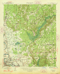
 - 1941 Map of Bossier Point
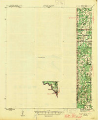
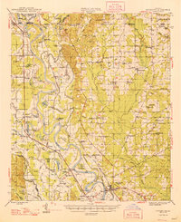
 1941 Bossier Point1941 Print · USGSThe marshlands and bottomlands of Bossier Parish come alive in the early 1940s, showing a landscape defined by the shifting waters of Lake Bistineau. Genealogists can trace family footprints at Fairview Cem or locate rural landmarks like Bear Island Sch and the Burkett Bridge.
 - 1943 Map of Waskom, 1954 Print
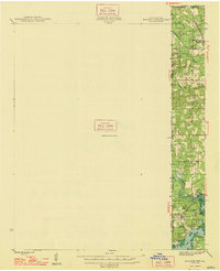
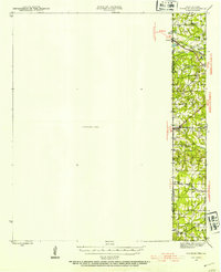 1943 Waskom1954 Print · USGSThe Texas-Louisiana borderlands in the 1940s were a network of rural schools and rail-side settlements. Genealogists can trace family footprints through numerous sites like Union Chapel, Richmond Sch, and Forest Park Cem along the interstate line.
 - 1944 Map of Kildare, 1954 Print
 1944 Kildare1954 Print · USGSThe tri-state border region of Texas, Louisiana, and Arkansas comes alive in this mid-century survey of the bayou country. Genealogists and researchers can trace local landmarks like Mission Chapel, the settlement of Trees, and the rail stops of the Kansas City Southern.
 - 1944 Map of Caddo Lake, 1954 Print
 1944 Caddo Lake1954 Print · USGSThe Texas-Louisiana borderlands come into focus in the 1940s, showing the intricate bayou networks and rural communities along the state line. Genealogists can locate family landmarks like Jefferson Forks, Shiloh Sch, and the McDonald Cem tucked between the waters of James Bayou.
 - 1945 Map of Grand Cane
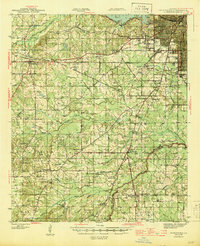
 1945 Grand Cane1945 Print · USGSDe Soto Parish during the mid-1940s is defined by its rural settlements and sprawling agricultural estates. Researchers can locate numerous local landmarks including the Longstreet Rosenwald School, Park Dots Plantation, and Smyrna Church.
 - 1945 Map of Waskom
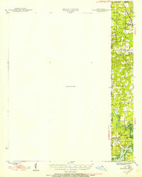
 1945 Waskom1945 Print · USGSThe Texas-Louisiana borderlands come into focus during the mid-1940s as rail and road networks began to reshape rural Harrison and Panola counties. Genealogists can trace family landmarks like Forest Park Cem, Union Chapel, and numerous schools including Waco Sch and Liberty Sch.
 - 1945 Map of Greenwood
 1945 Greenwood1945 Print · USGSShreveport's southwestern outskirts and the rural reaches of Caddo Parish are captured here during the mid-forties. Genealogists can trace family names through numerous landmarks like Marshall Cem, Hall Grove Sch, and the Caddo Parish Penal Farm.
 - 1945 Map of Socagee Bayou
 1945 Socagee Bayou1945 Print · USGSThe Texas-Louisiana borderlands come alive in the mid-1940s as the Sabine River winds past rural homesteads and timber tracks. Researchers can trace the foundations of local life through the Southern Pacific rail line at Logansport and historic sites like Hogeye Cem and Shiloh Sch.2 unique versions available
 - 1945 Map of Mansfield, 1956 Print
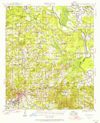 1945 Mansfield1956 Print · USGSDe Soto Parish in the mid-1940s centers on the rail junction at Mansfield just as the local landscape transitioned toward the post-war era. Genealogists can locate family sites at Evergreen Cem, Rock Chapel, and the historic Mansfield Battle Memorial Park.
 - 1946 Map of Caddo Lake
 1946 Caddo Lake1946 Print · USGSThe Texas-Louisiana borderlands come into focus in the mid-1940s, showing a landscape shaped by the waters of Caddo Lake. Genealogists and local historians can trace the foundations of rural communities through sites like Latex, Republican Ch, and Shiloh Sch.
 - 1947 Map of Ringgold
 1947 Ringgold1947 Print · USGSNorthwestern Louisiana comes to life in the 1940s, centered on the growing town of Ringgold and the expansive waters of LAKE BISTINEAU. Trace local roots through rural landmarks like the NEW SALT WORKS, St Johns Ch, and the Ogden Spur railroad line.
 - 1947 Map of Mansfield
 1947 Mansfield1947 Print · USGSIn the late 1940s, the De Soto Parish landscape centered on the rail hub of Mansfield and its surrounding plantation lands. Genealogists can trace family roots through numerous rural landmarks like the Lands End Plantation, Rock Chapel, and the Evergreen Cem.
 - 1948 Map of Coushatta
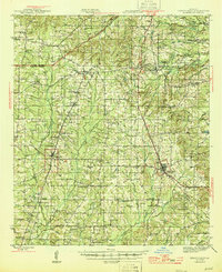
 1948 Coushatta1948 Print · USGSRed River Parish and the surrounding hill country are captured here just after the war, showing the intricate river-and-rail network. Genealogists can trace family names through dozens of landmarks like Elizabeth Sch, St Pauls Cem, and Hall Summit.
 - 1948 Map of Kildare
 1948 Kildare1948 Print · USGSThe Texas-Louisiana borderlands in the late 1940s reveal a landscape of rail-driven settlements and bayou wetlands. Genealogists and historians can trace old landmarks such as Bonham Landing, the village of Trees, and the Mission Chapel near the Caddo Parish line.
 - 1948 Map of Mooringsport
 1948 Mooringsport1948 Print · USGSNorthwest Louisiana's oil and river country is captured here during the late 1940s, showing the early growth of Mooringsport and Oil City. Researchers can trace rural lineages through numerous local landmarks like the Evening Star Sch and Albany Ferry.
 - 1948 Map of Vivian
 1948 Vivian1948 Print · USGSUpper Caddo Parish in the late 1940s is defined by the winding Red River and a thriving rail-and-oil economy. Genealogists can trace family roots through numerous rural landmarks like the Oil Refinery near Lewis, the Miller Bluff Ferry, and Egypt Hill Cem.
 - 1948 Map of Bossier City
 1948 Bossier City1948 Print · USGSNorthwestern Louisiana during the late 1940s reveals a landscape shaped by the Red River and the expansion of the Bossier City area. Researchers can trace rural family sites near Benton or locate historical landmarks like Barksdale Field and Red River Ch.
 - 1948 Map of Caspiana
 1948 Caspiana1948 Print · USGSNorthwest Louisiana south of Shreveport is captured here in the late 1940s as the river-and-rail economy shaped the Red River Valley. Genealogists can trace family footprints across dozens of rural landmarks like Blenheim Sch, Robinson Chapel, and Evergreen Cem.
End of results
Showing maps 1-20 of 20
Top cities of Caddo Parish
- Shreveport historical maps
- Vivian historical maps
- Blanchard historical maps
- Greenwood historical maps
- Oil City historical maps
- Mooringsport historical maps
See more
Frequently asked questions
- What are the different types of historical maps available for Caddo Parish?
- What is the oldest map of Caddo Parish?
- Where can I purchase historical maps of Caddo Parish for my home or office?
- Where can I download high-res historical maps of Caddo Parish?
- Are there historical topographic maps available for Caddo Parish?
- Is there historical aerial imagery available for Caddo Parish?
- Where are historical maps of Caddo Parish sourced from?